Trekking the largest cave in the world: Hang Son Doong, Vietnam, part four.

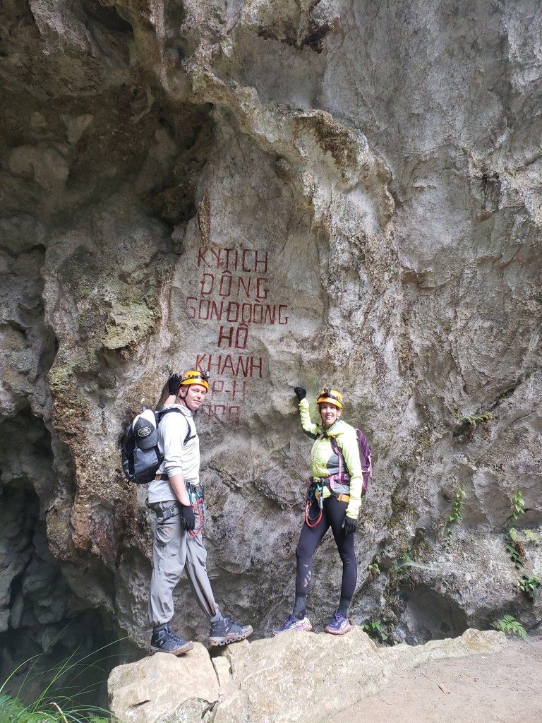
Day 4 (This is part four of a multi-part series. To start at part one, click here: https://authorrickfuller.com/2024/03/24/trekking-the-largest-cave-in-the-world-hang-son-doong-vietnam/)

Waking up on the final day of a long trek brings a bittersweet feeling. The tour has been lengthy enough that you’re ready for it to conclude, yet you know you’ll miss it once it’s over. You’ll look back on this moment, wishing you could return, spending more time soaking in the sights, smells, and the magnificence of this transient experience. The outside world awaits with its ebbs and flows, the hectic, frenetic pace of normal life that we’ve nearly forgotten while immersed in this incredible cave with no external contact. We understand that we must rejoin that world, ready or not, and so this ultimate wakeup carries a sense of anticipation tinged with a slight foreboding, blending into that undefinable bittersweet sensation.

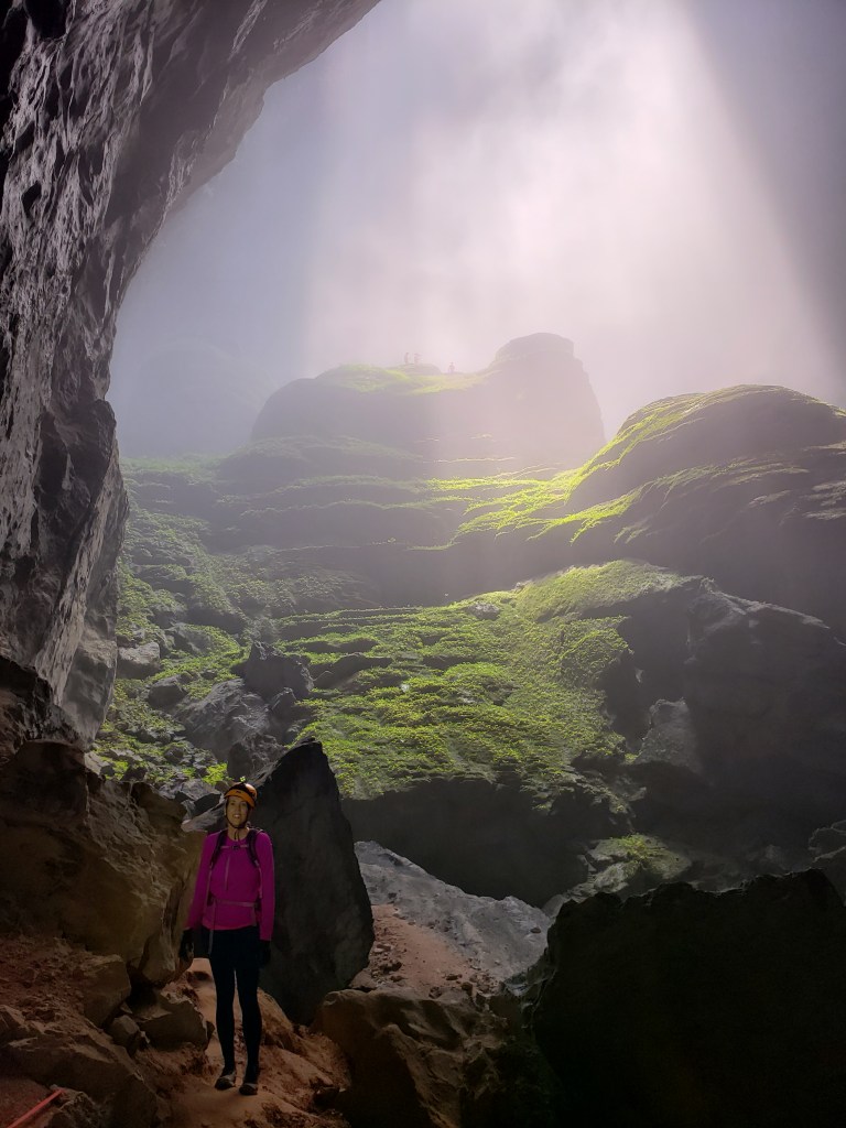
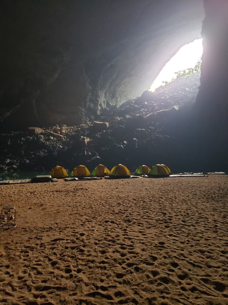
I’m awake this morning at 4am, the darkness and peaceful quiet of the still camp telling me the approximate hour before my watch confirms it. I know that this is going to be a taxing day full of grueling ascents and descents, and sleep is going to be paramount toward getting the most enjoyment out of the effort, and yet the anticipation of the day forces sleep to elude me. I lay restlessly until 7am and then finally exit the tent to a dot of blue sky in the doline far above. The normal routine of coffee and organization of our gear follows before the call to breakfast is given. Our fare this morning is French toast, called “egg toast” by our team, which allows me to pretend that I’m not eating French toast after all and thus, do not need any maple syrup. Accompaniments include fried rice with and without meat, and lots of fried and steamed vegetables, and there is, as usual, too much for us to even come close to finishing.

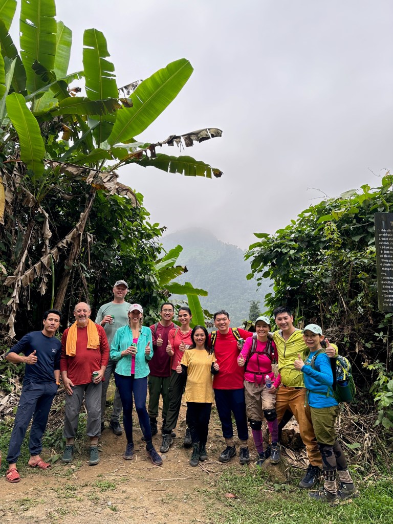
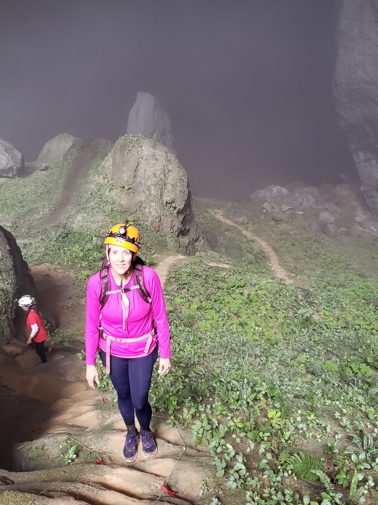
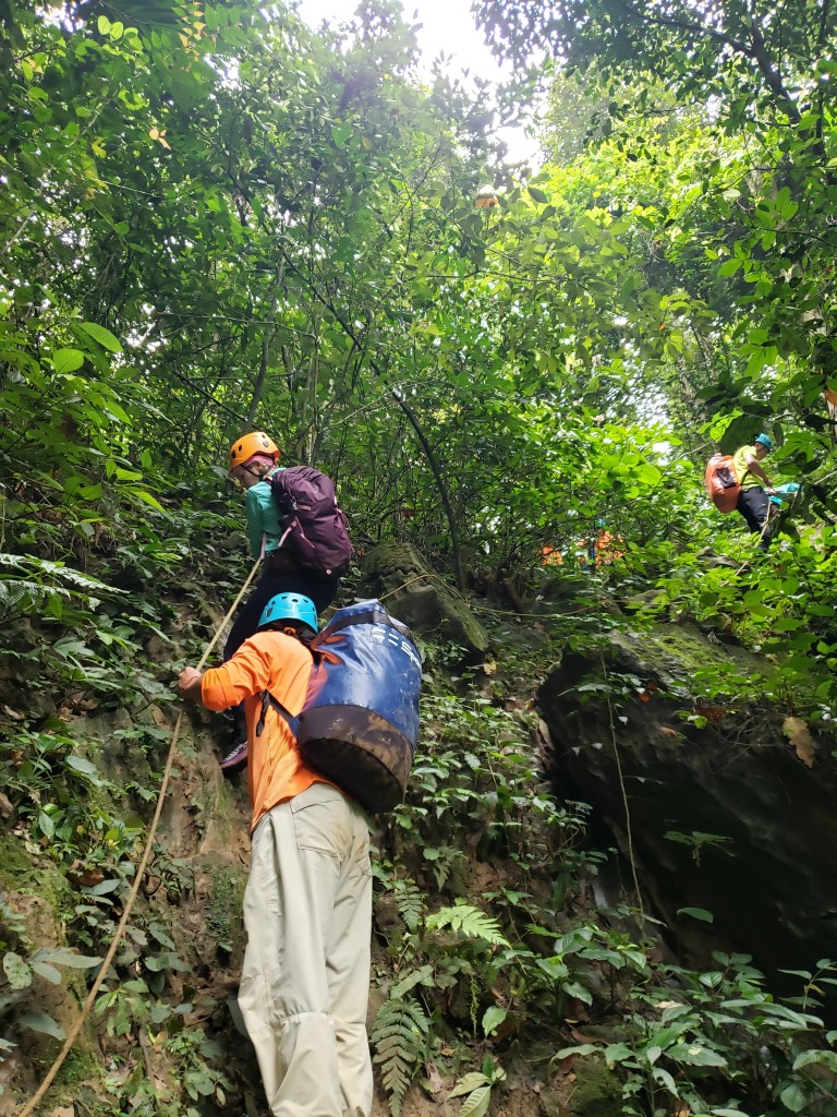
After breakfast, we don the five-point safety harnesses which the safety assistants secure under the watchful eye of Hieu who double-checks their work when they finish. Today we’ll be exiting the cave via a strenuous and long climb, and harnessing us here in the light from the doline is much easier and safer than trying to do it in the darkness later, despite the large distance we still have to traverse before they’re actually needed.

The final group photo before leaving camp three.

We leave camp at 9:15, trekking away from the light and into the darkness once more, headlamps atop caving helmets illuminating the gloom, carabiners clanking rhythmically to our steps. Even our group’s safety assistants are quiet this morning, a pensive and almost maudlin countenance on every face that flashes though my light. I have no doubt that for them, this is always rather difficult. They’ve gotten close to many of us, chatting and sharing life stories, and they know that they’ll likely never see us again after today. And then, after a few days of resting at home, they’ll meet a new group of ten and start over, in a repeating cycle of almost getting to know someone before they leave your life forever. While we’ll remember their faces for a long time, both in the memory of an incredible experience and in photo, the memory of our faces will quickly ablate to them, fading away to be forgotten in the blur of client group after client group.  

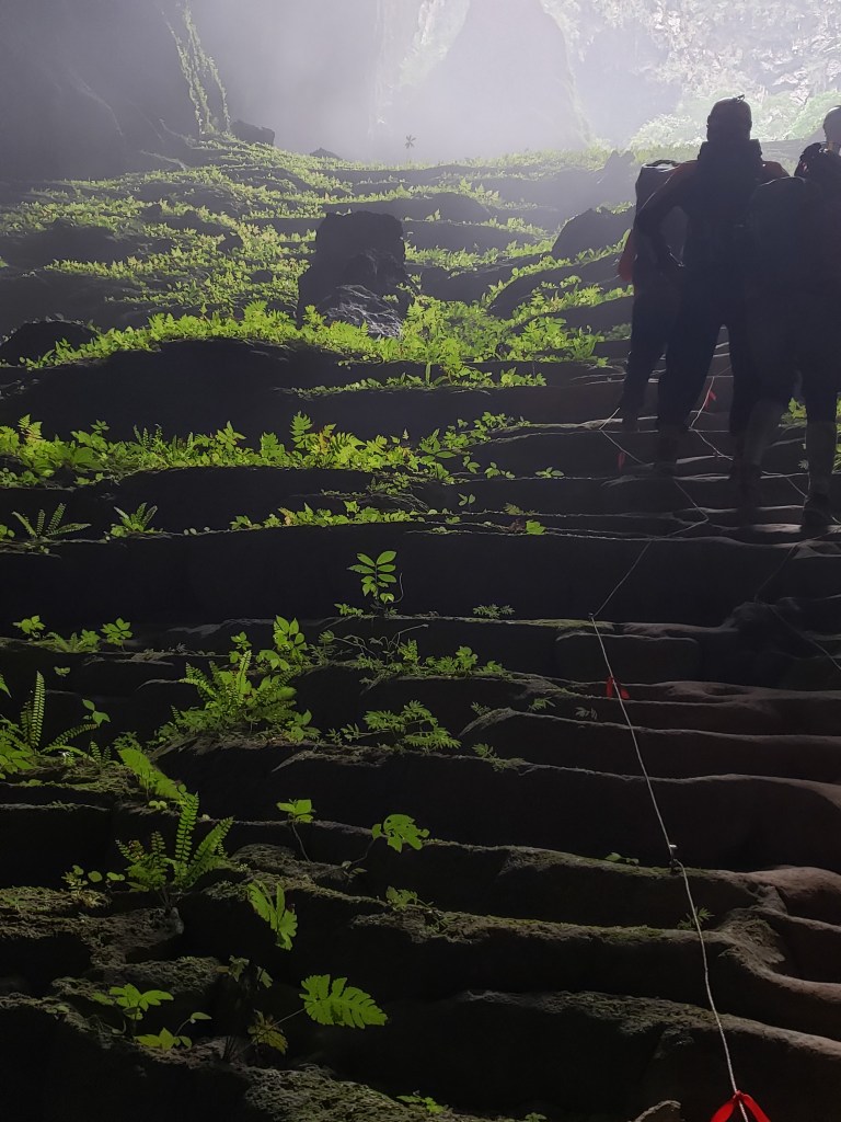
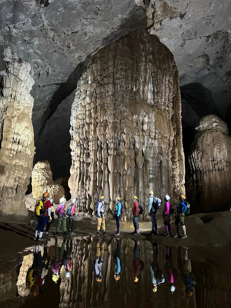
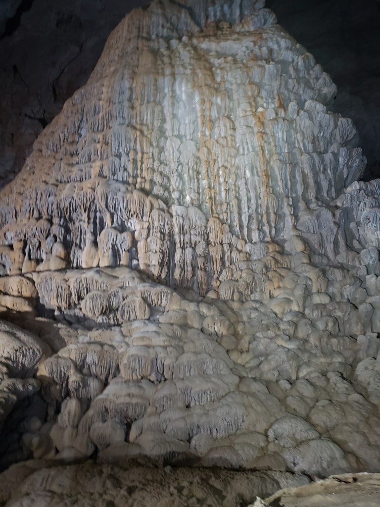
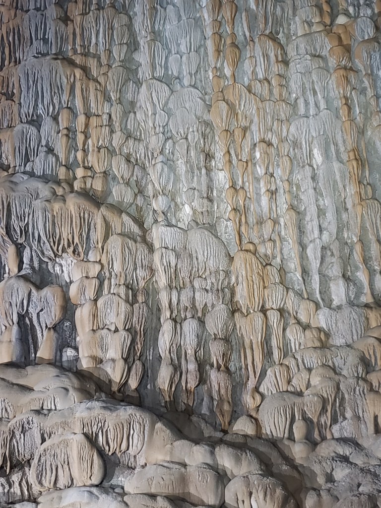
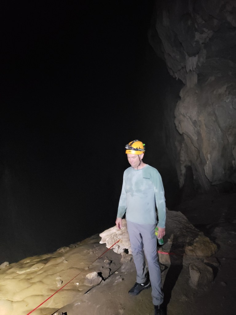
Our path today is flat and easy, well-marked with ribbons that keep us from marring the ancient formations we pass. And these formations are absolutely magnificent. Massive stalagmites once again greet us as we wind around them, trekking over voluminous calcite flows that often seem to have sprung from the walls. We stop at a stalactite formation with a very unique shape called “The Dog’s Bollocks” that comes to a point maybe four feet off the ground, a perfect spot for posed photos, and all but one of the group participates with joy, the lone holdout a curmudgeonly old naysayer dashingly youthful adventurer who looks on with impatience and annoyance contentment and delight.

*Confession: It was me. I was the lone holdout.  

While the photo shoot ensues, I take the time to study the incredible formations caused by millennia of dripping water. My writing skills are not up to the task of describing these ridiculous etchings which seem to somehow have both uniformity and chaos, a random walk in a roomful of mirrors perhaps. I’ll let the picture speak where my skills lack.

Just one of the dozens of massive columns that adorn this ancient cave.
The intricate carvings and colorations from millions of years of water leeching are strangely captivating.

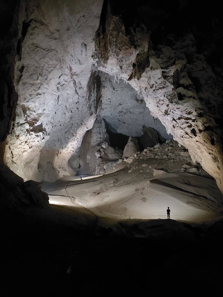
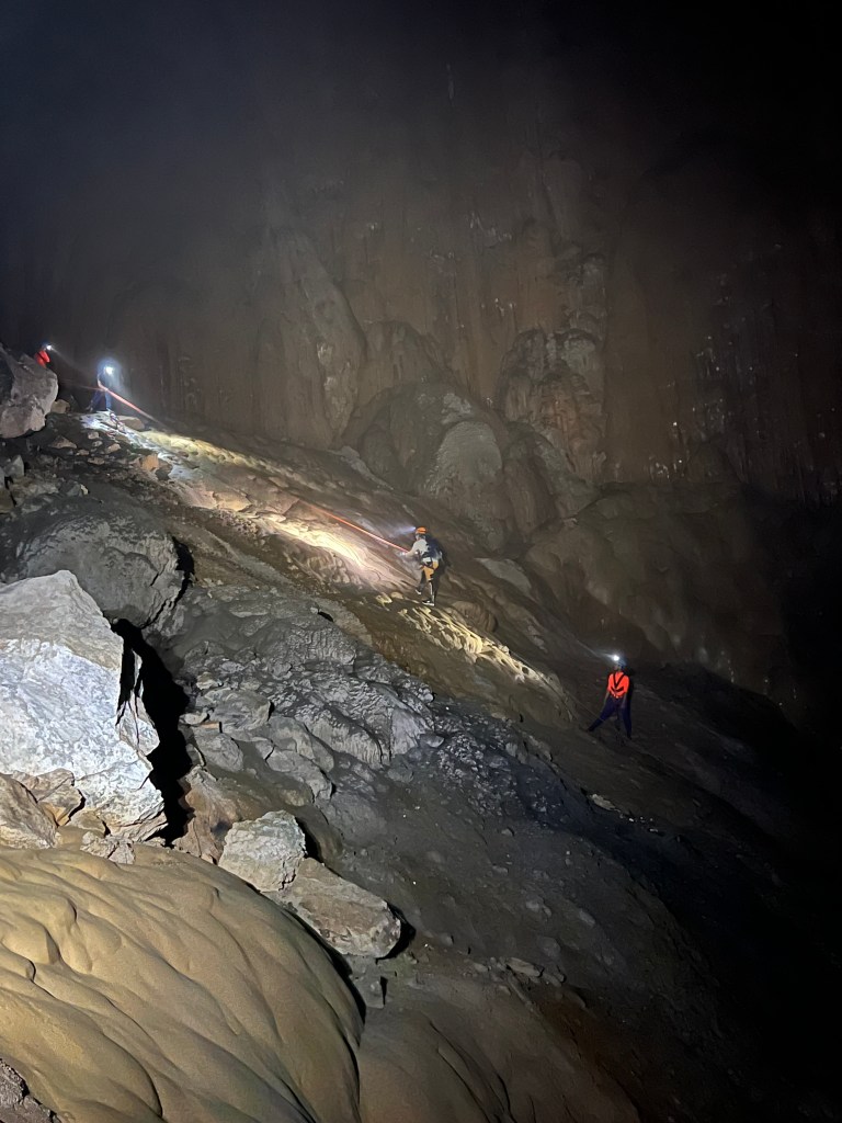
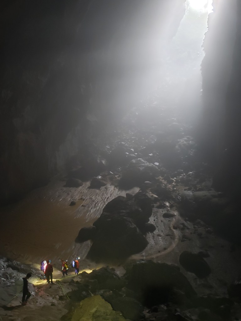
After an easy walk in the magnificent forest of cave formations, we traverse massive underground sand dunes, safety assistants spreading out once more with powerful lights to display the full grandeur of the massive cave that houses these unique dunes. We then pass an area that is packed with cave pearls trapped in intricately weaving gour dams formed by shifting waters and swirling minerals. These alone would be fascinating artifacts were it not for the massive sensory overload of four days of this cave. There are only so many ways to say, “magnificent, huge, amazing, spectacular, incredible, and mind-blowing,” and my brain is spilling over with the sights I’ve seen. I can’t take any more magnificence, and this more than anything else tells me that it is indeed time to get back to the real world.

Ride along with me for five minutes of cave trekking.

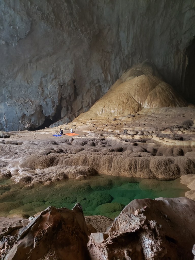
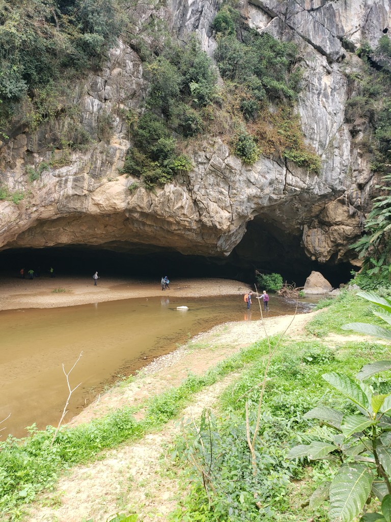
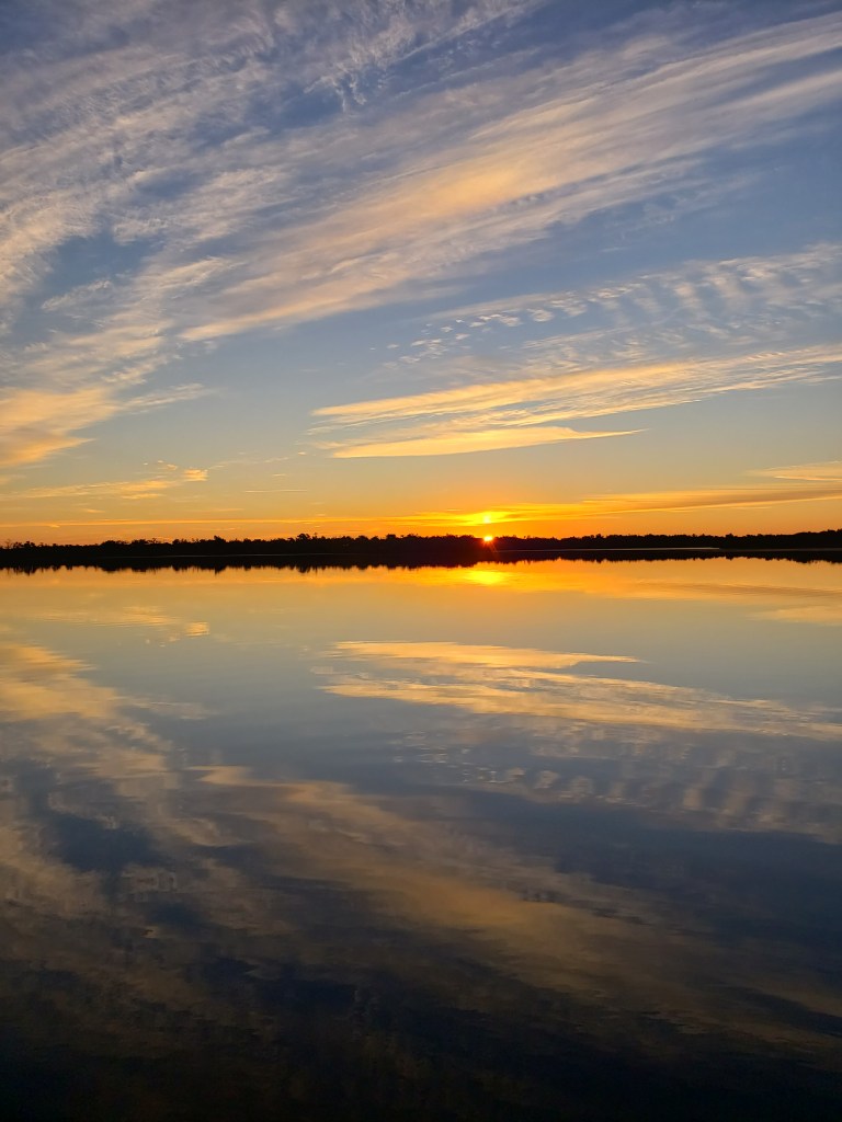
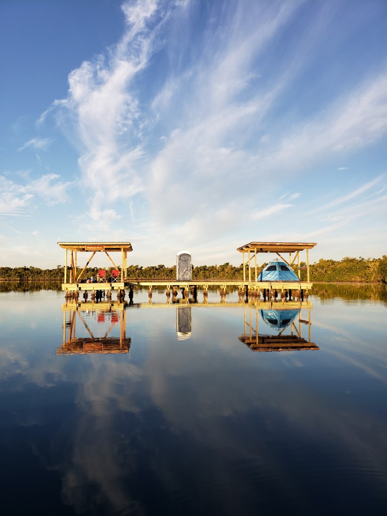
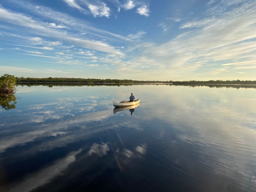
We move on, crossing a region of sand dunes and then through a massive cavern which the crew lights up for us again. After an appropriate amount of marveling, we trek across the cavern and drop down by means of a rope handhold and soon arrive at the lake zone. This is a wide spot in a massive cavern, and in some seasons, this is a tremendous (magnificent, huge, amazing, spectacular, incredible, mind-blowing) lake that is held at bay by the natural dam known as the Great Wall of Vietnam. More on that in a minute.

Sand dunes in yet another massive cavern.

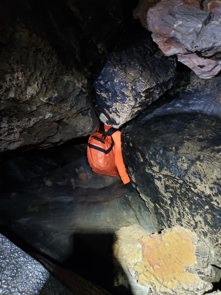
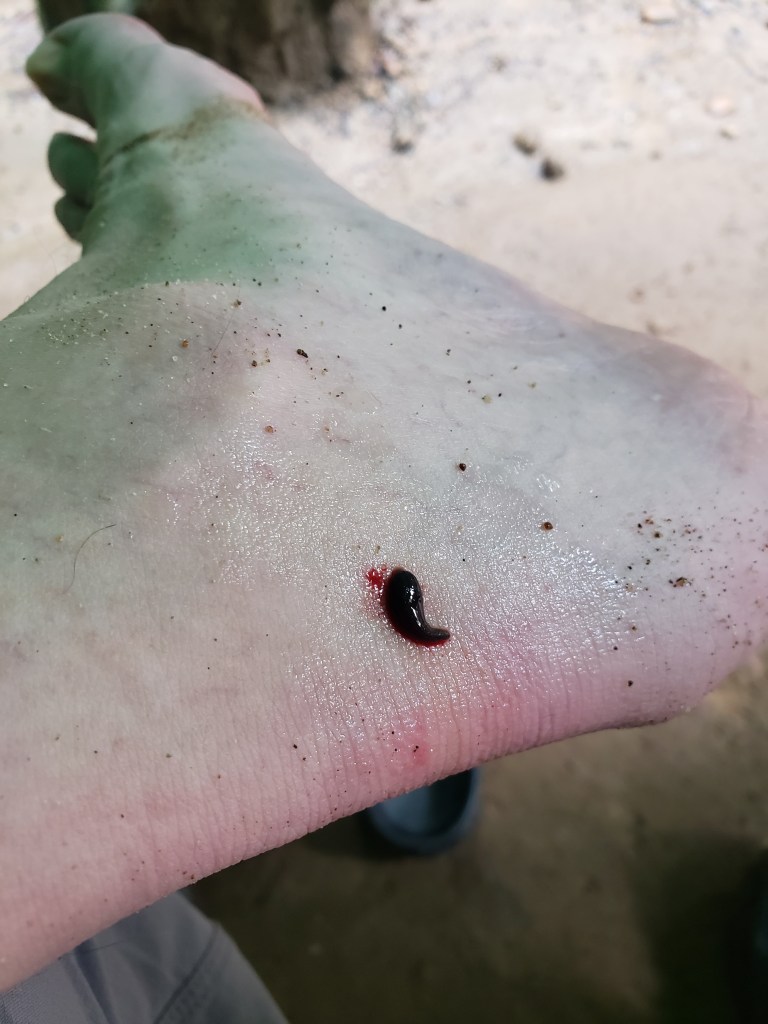
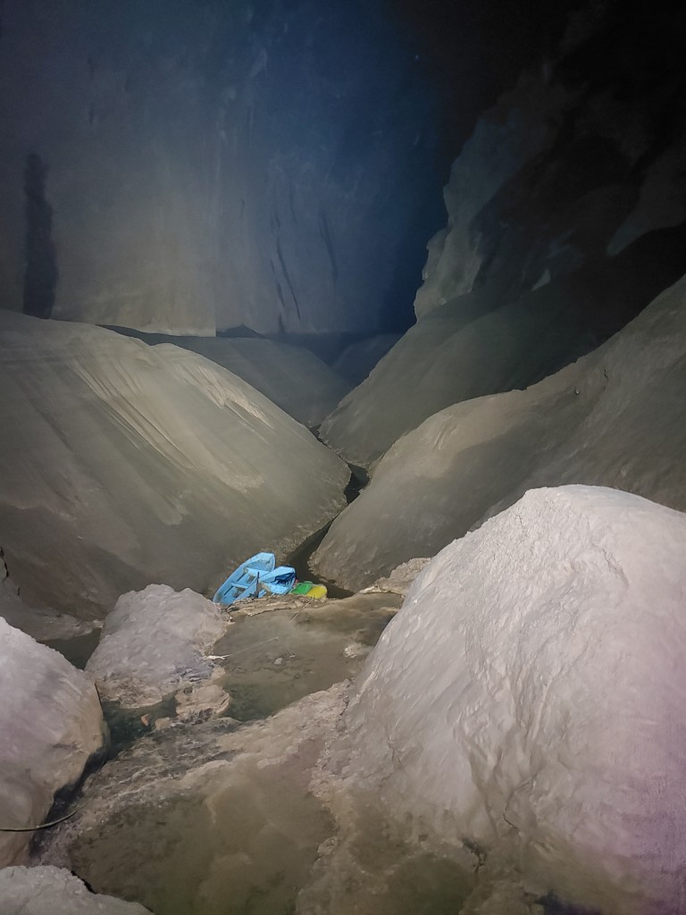
This lake is often deep enough so as to require passage by boat. Today, it is a huge field of mud, and these boats are tied up in front of us, resting on the mud as if waiting for the tide. Because there is no lake at the moment, our destiny is a muddy trek away instead, and we wind down into a very narrow channel approximately six to twelve inches wide, with steep, muddy slopes spanning up and away ten to fifteen feet high on both sides. The channel contains three to four inches of mud with about a foot of water on top, and we splash through that channel in single file, using our hands against the muddy walls of the bank to steady our approach. The mud sucks at our feet with every step, and the serpentine path winds its way forward, unseen deeper spots forcing a slow passage lest we trip or stumble and end up covered in the viscous goo that now surrounds us.

Forlorn trio of boats waiting for the flood.

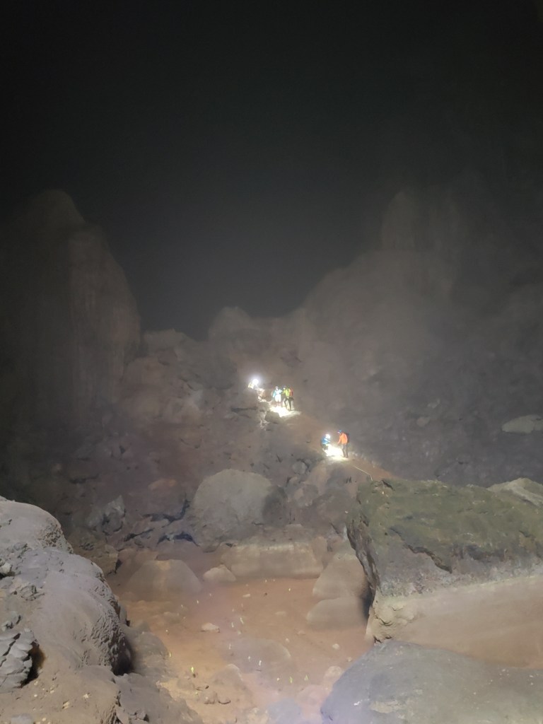
One of the safety assistants leads the way, and Jeremy and I follow, quickly outpacing the rest of the group, the only sign of their passage the occasional reflection of light from their headlamps. After thirty minutes of walking the thin line like a drunk performing a sobriety test, with, much like that drunk, many stumbles and lots of arm waving for balance, we finally arrive at the Great Wall of Vietnam.

This wall was first encountered by the British caving team during their exploratory surveying. A massive vertical wall that disappears into the darkness above, they originally had no way to scale it. By turning off their lights, they could see a faint glimmer of daylight far above, and they had no way of knowing if they were seeing the exit from the cave or yet another doline. Returning with climbing equipment, they now had to figure out how to drive anchor bolts into calcite, a task that does not inspire confidence when one is ascending a great height. The story of these cave experts solving the puzzle of conquering the Great Wall is a good one, but beyond the scope of this blog, however, one line tells the tale better than any other:

“8 meters up seems a long, long way when you’re 5 kilometers into a cave, 10,000 kilometers away from home, hanging from a bolt installed in something with the consistency of wet putty.” – Sweeny, member of the BCRA, who first conquered the Great Wall of Vietnam.

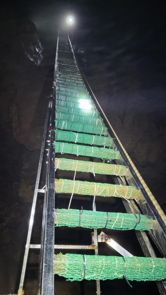
Because the ascension of the wall remained difficult and dangerous for many years, until 2017 tours ended here, clients forced to retrace their steps all the way back through the cave, exiting the same way they came in, a longer and more exhausting tour undoubtedly. Today, the wall has been solved via a massive (amazing, spectacular, incredible, huge…) ladder.

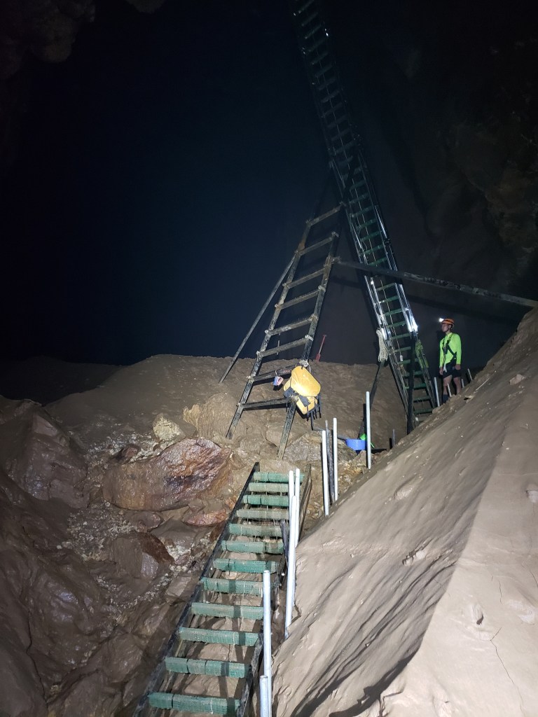
This ladder, made of steel and reinforced with supports that have been drilled through the wall and massive struts, rises 120 feet in height, its top disappearing into the darkness, beyond the reach of our headlamps. Jeremy and I stand on a narrow ledge below the ladder, the river roaring away just barely visible below us, a potential fall disastrous as any slip would lead us to undoubtedly be swept away, into the river and underground, and the waiting here seems rather pointlessly dangerous as we shuffle on tired feet trying not to bump each other off the ledge and into oblivion.

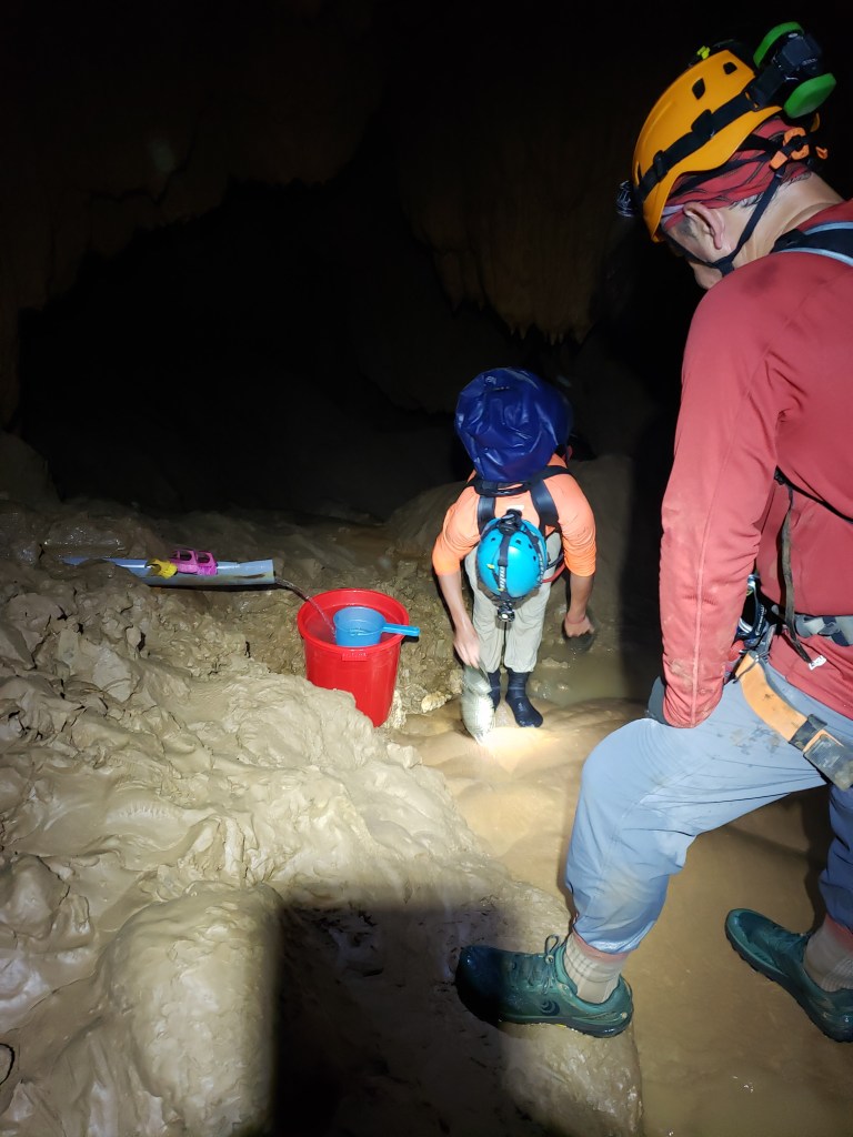
There is a pipe that is tapped into the river, and water pours from it into a bucket with scrub brushes. The safety assistant who led us here scrubs himself clean of mud before calling us over one-by-one to scrub the mud from our boots and legs. Any trekking of mud onto the ladder or onto the wall that awaits somewhere above the ladder would make it slippery and dangerous for those following, and the crew takes their time removing all vestiges of mud with scrub brushes dipped into the bucket.

Waiting our turn at the foot washing station prior to ascending the Great Wall of Vietnam.

When we’re clean, we stand on a curved and sloping rock just inches away from that potential tumble into the rushing river, and I hope that I haven’t done anything to offend Jeremy over the last three days as we await the arrival of the rest of the group. Luckily the surface on which we stand has the consistency of sandpaper, and traction is great, though the looming chance of death behind us serves to keep our apprehension elevated.

Tha arrives along with the other safety assistants, and they clean themselves off before the assistants scoot up the ladder to secure their positions on the wall where they’ll be helping guide us from section to section of this long climb back to the surface. The waiting game drags on as orders are shouted in Vietnamese up and down the height of the wall, and the anticipation of this exercise keeps all of us buried in our own thoughts. Finally, Tha signals that we’re ready to begin.

We pair off in groups of two, and Tracy and I are elected to be the first to climb. Tracy motions me forward and I step first onto a horizontal ladder that spans ten feet over the raging river. Iron bars rammed into the muddy bank provide handholds and I quickly cross the span and then stand at the bottom of the massive ladder. I can’t help but marvel at the herculean effort required to move a gargantuan contraption like this first into the cave, and then into position at the base of the Great Wall. 120 feet in height and bracketed into the wall with thick steel supports, the story of how it was placed is one I want to hear. However, there is no time.

Tha checks my boots once more and finds them not clean enough, so he takes another scrub brush to them to eliminate the remaining mud. He then clips my center ring into a rope and shouts up into the darkness far above. Slack is pulled up and my harness straps are pulled taut. Tha and I nod at each other and he gives me the green light to begin the climb.

Stairway to heaven

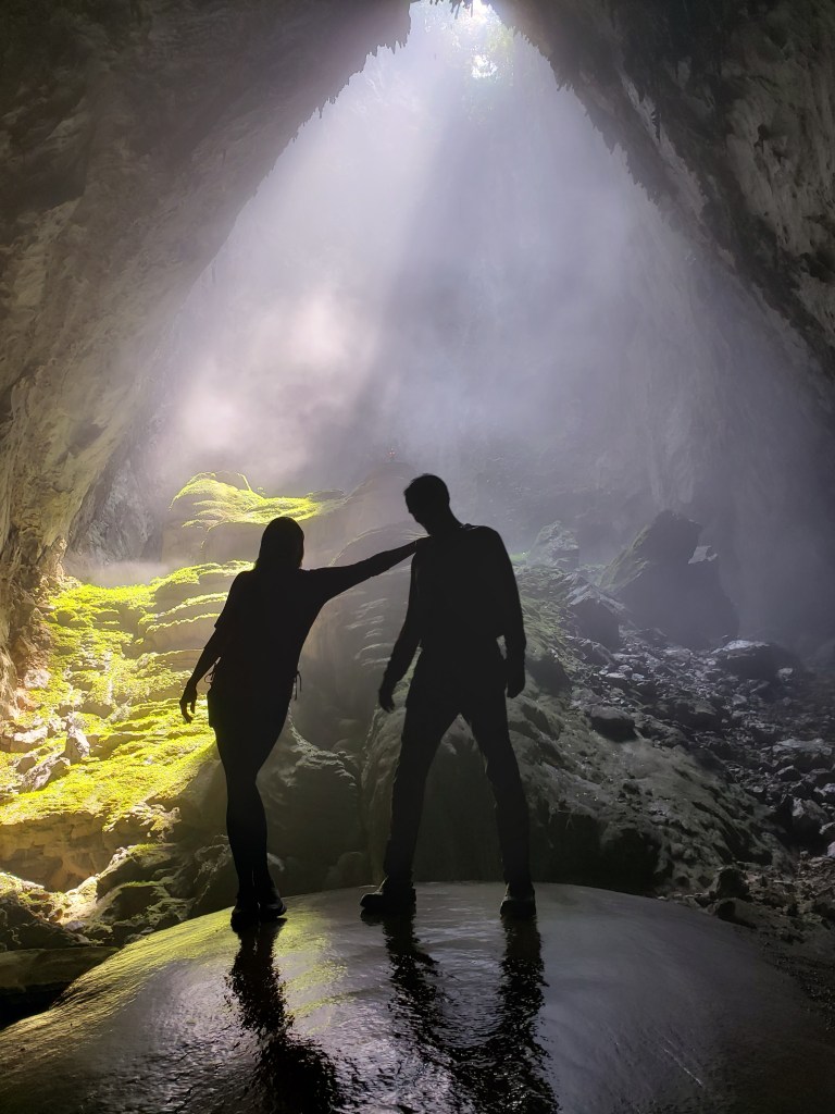
I move quickly, admiring the views as I ascend into the darkness, the vertical wall getting closer as I near the top. I’m breathing hard when I reach the top, and beads of sweat have begun to coat my body in the thick humidity. There’s a narrow ledge here where the pitch of the Great Wall turns from 90 degrees to about 60 degrees, and I step off the ladder and onto that ledge. The safety assistant waiting there clips my two free carabiners onto a safety rope that is anchored to the wall, and then clips a new support rope to my center ring. He asks me if I want to rest, but I am amped up and I reply, “No, let’s go.” He calls up the slope far above and the slack in the new rope is pulled up, and I begin to climb again, leaning back with the rope between my legs and my boots grabbing purchase on the sandpaper-like slope of the wall. I again move quickly, climbing as fast and hard as I can in some bizarre race to outclimb the safety rope. I have no idea why I feel that I need to outclimb the safety rope or why I can’t just enjoy the climb, but the purely fabricated competition drives me to the top. By the time I reach the next ledge, perhaps forty meters above the top of the ladder, I’m drenched in sweat, panting for breath, my arms weakened through the effort. Here, I do take a quick break, until I hear the shouts from below and realize that Tracy has begun her ascent of the ladder. Panic over potentially being a cog in the operation rears up, and my race against my own brain begins anew. Still panting like Seattle Slough on the 10th furlong, I nevertheless grab the new line and step onto a 45-degree slope, racing my way up this last section until I triumphantly arrive at the very top of the wall.

I’ve won the race. Against myself. Yippee.

I’m drenched in sweat but I couldn’t be happier.

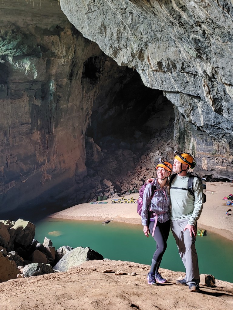
The Great Wall of Vietnam is a truly amazing feature of Hang Son Doong, and by my estimation, more people have ascended to the top of Mount Everest than have climbed this wall, which means very little except in my head, but which is still a pretty cool stat nonetheless. After Tracy reaches the top, we are escorted off to the side of the cave where a large shelf juts out, providing a nice viewing area of the top section of the climb. From there, we cheer on the rest of the group, taking pictures and videos and shouting encouragement. After the last climber, the rest of the safety team climbs up, moving far quicker than any of us, including myself, while carrying their big, heavy packs. They are truly impressive.

The last few steps of the great climb.
Tracy, Rick, and Damien: sweaty, tired, and very happy.
Just a few more ups and downs before we exit the cave for good.
The final treacherous descent. At least the final one INSIDE the cave.

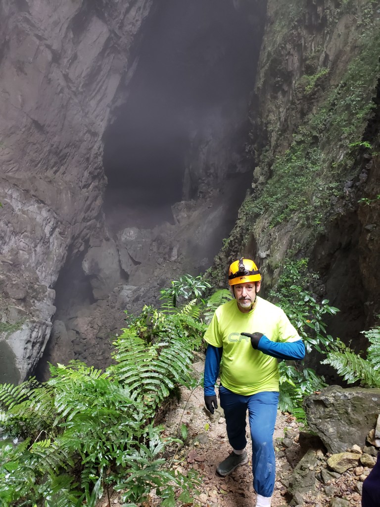
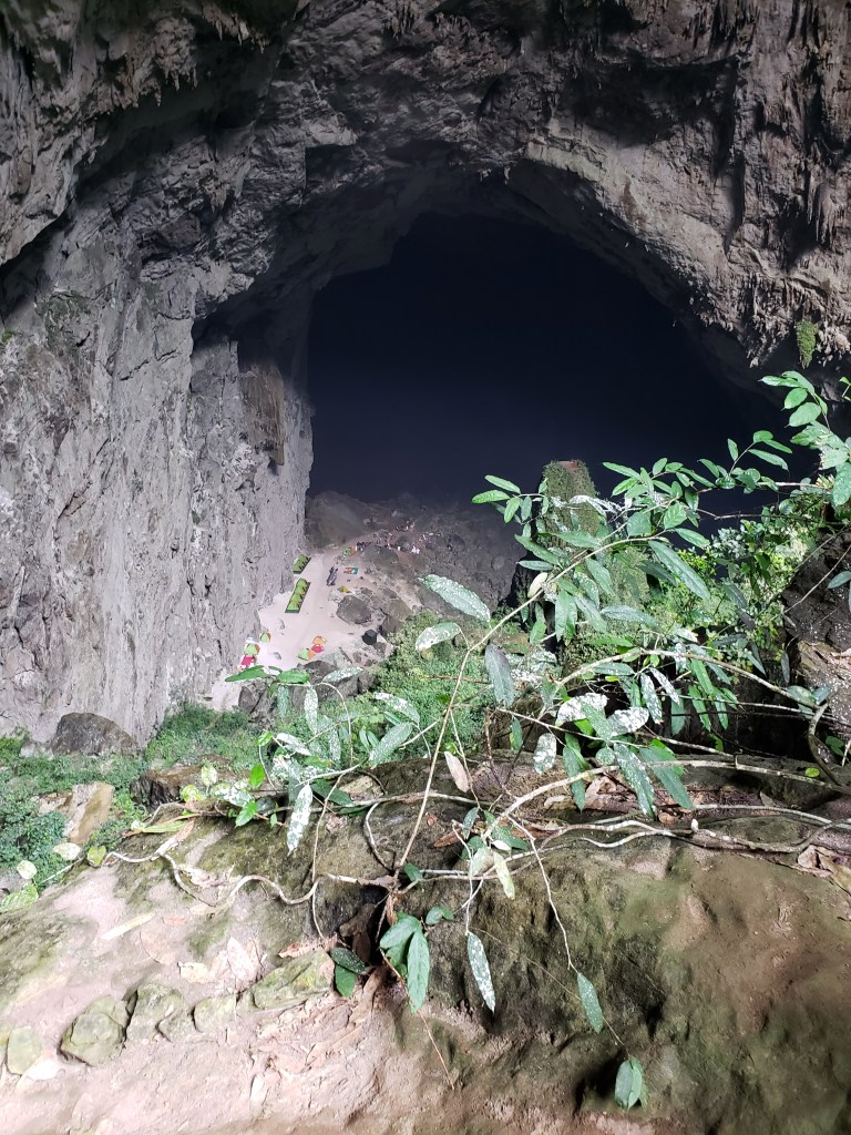
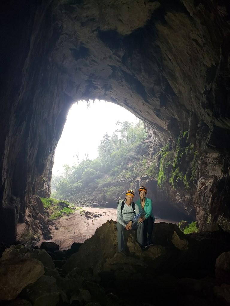
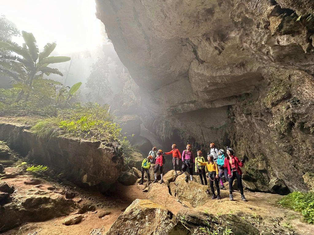
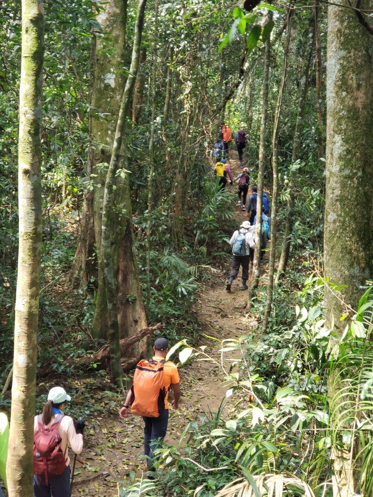
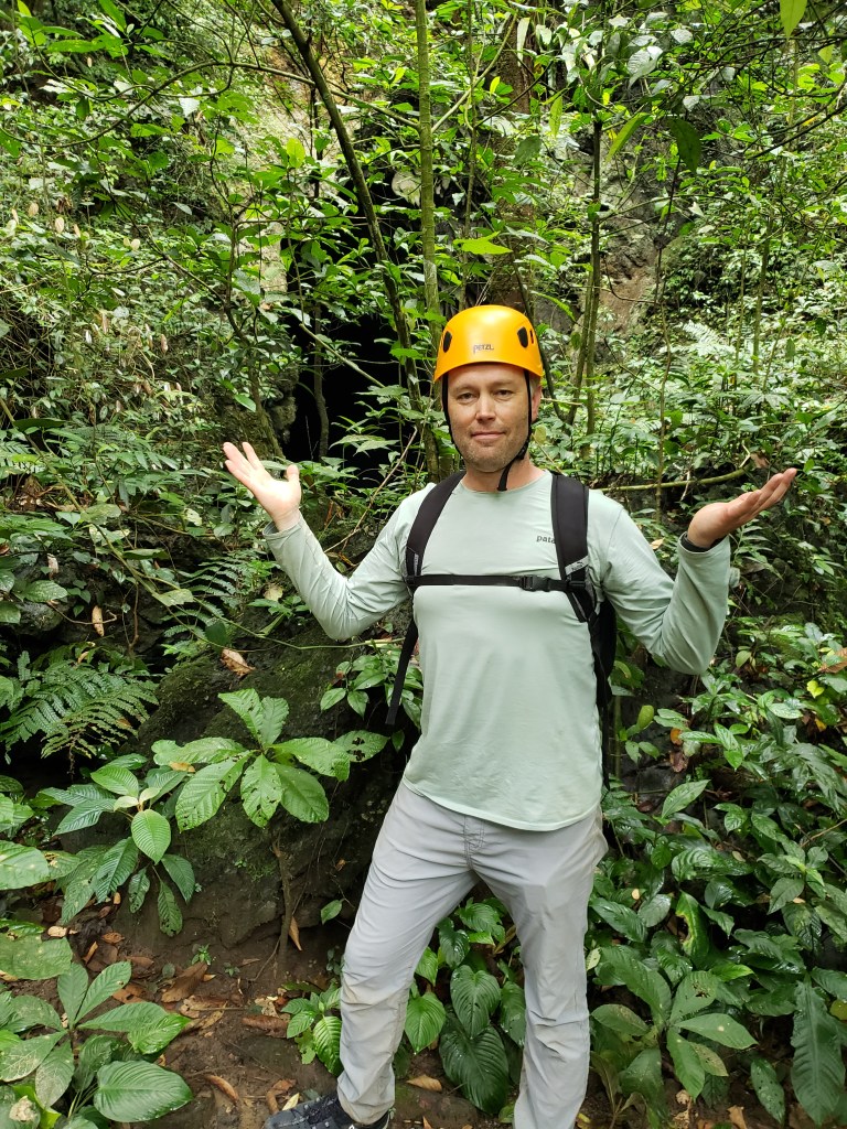
When all have safely navigated the climb, we have lunch, the light from the cave exit visible in the distance. The cave trek is ending, and we are all flying high from the much-anticipated climb of the Great Wall. Lunch finished, we move quickly the remaining distance and then climb a steep, rock-strewn slope toward the light of day. After three days of immersion inside the largest cave on the planet, we step out of the cave and back into the jungle.

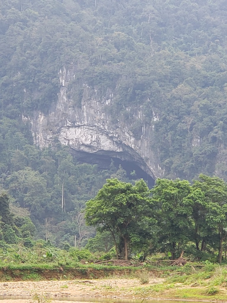
Only a few steps from the exit, the dark maw of the cave is swallowed by the jungle, all traces disappearing, and once again, this really reinforces the previously inconceivable idea that the cave had remained hidden for so long. Here, in the middle of a dense jungle, very high on the top of one of thousands of limestone monoliths, far from any civilization, this narrow opening, covered by the thick vegetation, could very conceivably have never been found.

Mere feet away from an entrance to the largest cave on Earth, and the jungle already begins to conceal it.

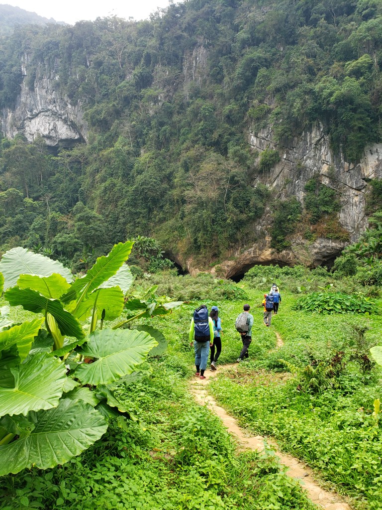
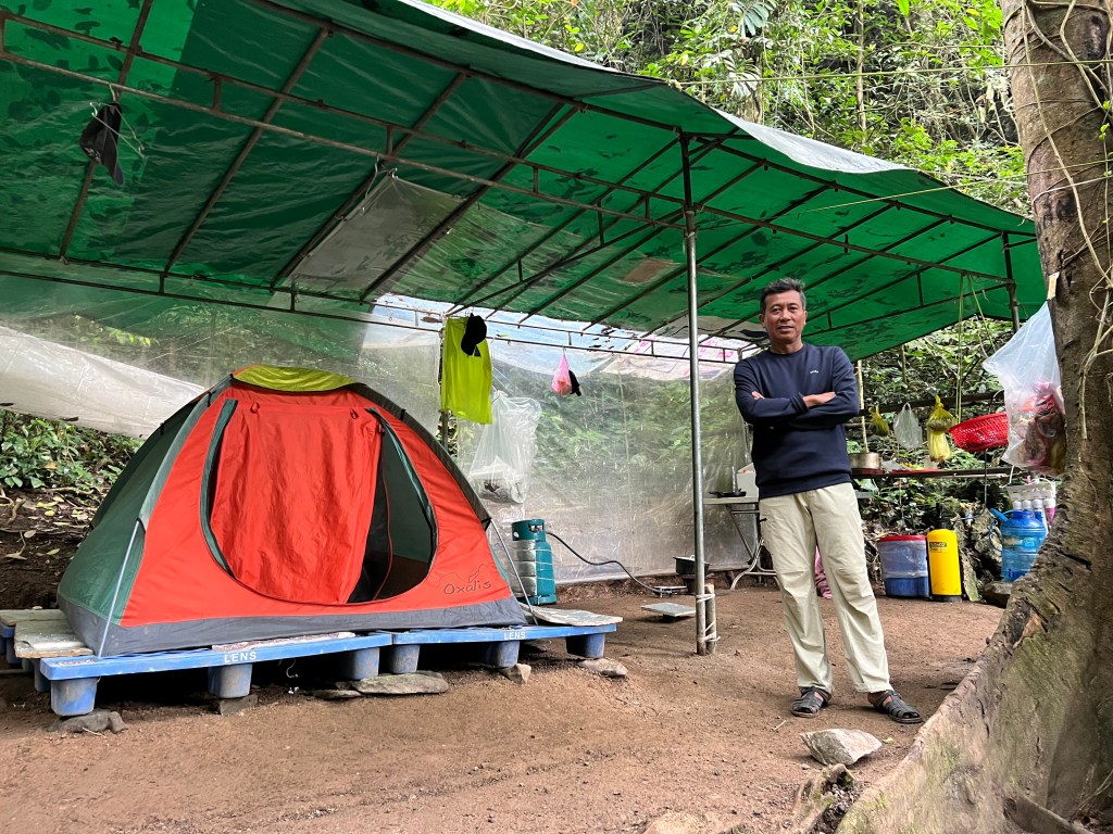
Although this feels like the end of the trip, it is anything but. In fact, the hard part is yet to come, a nice little secret not talked about by most. Unlike most, I spread truth, and I’m therefore going to be the first to tell you, that the descent from the cave exit is one of the toughest downclimbs I’ve ever done. We first pass a ranger who guards the cave from unauthorized visitors. I marvel at his camp which is perched very high on the mountain. Tha tells us that he will stay here for three to four days straight until he is relieved, and that this cave entrance is guarded 24/7. This job, sleeping in a tent in the deep jungle, far from civilization, out of cell phone range, all alone for three to four days, is one that I think would drive me completely crazy after more than a shift or two.

This guard stays here alone on top of a mountain, deep in the jungle, guarding the entrance to Hang Son Doong.

After passing the one flat spot on the jungle-covered mountain, we begin the descent. We’re told that our caving helmets are required for this descent, and though it annoys me to wear this thing in the heat of the day in the steamy jungle, I completely understand the necessity. The slope is rock-covered mud, with many spots that require holding onto a rope while navigating a slope of 70+ degrees. When we’re not trekking barely manageable slopes, we’re moving from knife edge to knife edge, wobblily stepping across chasms just waiting to break a leg. Tha tells me that he was seriously injured once on this descent when he gashed open his leg on one of the knife-edge rocks, and Hieu was so badly hurt in a fall here that he had to be carried out by the porter team. This descent is absolutely no joke, and we are all panting, aching, and covered in sweat by the time we finally reach the dry river bed that marks the bottom of the valley. Although it took only an hour to get here from the cave exit, it was by far the toughest hour of the entire trek, and we are exhausted.

The hardest part of the tour is the descent from the cave exit to the river valley far below.

We rest here for a bit, drinking water to rehydrate. I move up the river valley to relieve myself and find an entrance to yet another massive cave. Returning, I tell Tha about my discovery and ask if we can name it Hang Rick, but to my utter disappointment, he claims to already be aware of it, and in fact tells me that Oxalis provides a tour through it.

As I pick up my pack, I realize that Tha has filled the outside pockets with heavy river rocks, a rather funny joke that would have been better if he’d put them into the zippered pouches so I didn’t see them. I empty the pockets and we now climb out of the valley. It takes us 20 minutes of tough climbing on the well-trodden path before we pop out of the jungle and back onto the Ho Chi Minh trail. Jeremy, the old man of the group is the first to arrive, and when I pop out, he has already cracked open a beer which the crew has thoughtfully provided in an ice-packed cooler that is awaiting our arrival.

The porter team has beat us here (of course) and they lounge around in the shade, smiling and cheering for each of us as we pop up out of the jungle and onto the road. It’s 3:30pm and we are exhausted as we chug the beer and high-five all around. We truly feel that we’ve accomplished something incredible, and we’re excited and proud to have successfully and safely completed this incredible trek.

Celebrating an incredible, memorable trip with a well-deserved beer.

Epilogue:

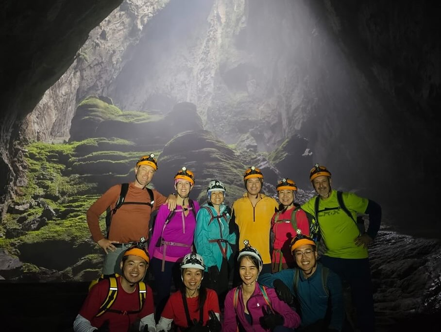
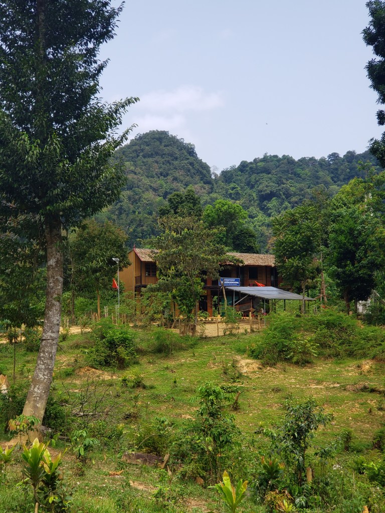
The tour doesn’t officially end at the roadside, though it may feel that way. The price includes a stay that night in a beautiful bungalow at a place called Chay Lap Farmstay, where the ten of us gather for a last supper with our guide Tha Tran, and our safety specialist Hieu Ho. The dinner is wonderful, and afterwards we take another group picture and then Tha and Hieu hand out wooden medals to commemorate our trek.

On the nightstand in our bungalow room was an envelope where we could provide an optional tip to the 26 members of the Oxalis staff who catered to our every need for four days straight and ensured that we successfully turned this dream into reality. When we first booked this adventure a year previously (the tours fill up early, and a one-year advance booking is usually the minimum) we weren’t sure that it would end up being worth the $3,000 per person that they charge. It seemed like a lot of money at the time, especially in a country like Vietnam where a dollar goes a long way. After taking the trek, we were actually stunned that it was so cheap. Two full-time chefs who make every meal into a delectable feast. 17 porters who each carry monstrous packs through an arduous trek where us clients sometimes struggled with just day packs. 6 safety assistants who watched our every step to ensure we were safe and injury-free. A safety supervisor specially trained by the British Cave Research Association with top-notch modern cave trekking knowledge and skills. And lastly, an incredible guide who had the most magnetic, energy-filled personality you could ever want. And this doesn’t even begin to touch on the staff at Oxalis who put all this together from the time of booking to the time of our departure. The fee includes round-trip transportation from Dong Hoi, the two nights in the different bungalows that bracketed the actual trek, the roughly $750 per person fee that the Phong Nha-Ke Bang National Park charges for entry, and many more things. After tallying up what it should have cost, we were actually amazed that it was so cheap.

Upon embarking on this trip, we made sure to bring enough Vietnamese money to tip the staff at the end. We planned on a local-appropriate tip of somewhere in the 5-10% range, depending on the level of service and our satisfaction with the tour. After we finished, we realized that this was nowhere near enough. The level of service was absolutely exemplary, and the professionalism of every member of the staff was far and above any reasonable expectation. We were so appreciative that we felt compelled to show our gratitude in the only way a client truly can, and that was through a much more generous tip than we’d originally planned, and it still felt like it wasn’t enough. It’s incredibly rare to experience 6-days and 5 nights on a tour and not think there was at least some mishap or room for improvement, but Oxalis has managed to create an exemplary tour that addresses every conceivable issue with first-class service that I am dying to repeat sometime soon. My recommendation could not be more glowing.

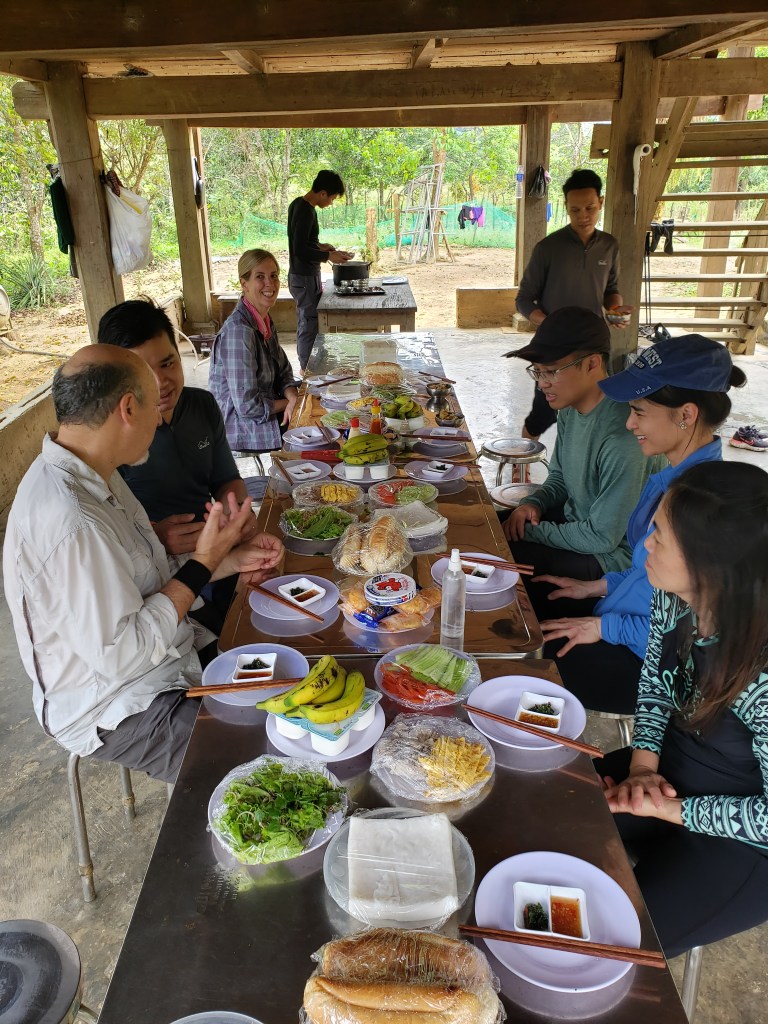
The day after we exited the cave we had time to relax in the very nice bungalow and resort area. Every bit of our laundry, which had to be as disgusting as possible after most of our clothes sat wet for three or four days in a plastic bag, was professionally done at a total cost of somewhere around $10, and was waiting outside our room when we woke up. I took a complementary bicycle and explored the town with a 5-mile ride on an idyllic country road that winds through lush farmland with the cloud-enveloped and jungle-covered limestone mountains as the backdrop. At noon, the provided car service picked us up and we were driven to the train station in Dong Hoi where we weren’t taking a train, but were instead picked up by another car service I’d booked to take us back to Hue. The rest of our Vietnam trip, both before and after the cave tour was absolutely wonderful as well, though those details will have to wait for another time.

A trek through the incredible Hang Son Doong is an unforgettable, life-changing experience, and if you get the chance to take this journey, have no qualms or second guesses, just jump on it. You will not regret it!

Trekking the largest cave in the world: Hang Son Doong, Vietnam, part three.

Day 3 (This is part three of a multi-part series. To start at part one, please click here: https://authorrickfuller.com/2024/03/24/trekking-the-largest-cave-in-the-world-hang-son-doong-vietnam/)

There’s really nothing like a cold-water plunge at the end of a long and strenuous day to facilitate great sleep, and the underlying knowledge that I was hundreds of meters underground inside the largest cave on Earth fortunately did nothing to encourage insomnia. In fact, the only thing truly interfering with a legendary sleep on this night was the poking of elbows and fingers from Tracy every time that I started to snore, something I don’t do often but is irrefutable evidence of the depth and quality of my sleep, all of which carried, apparently, no weight in her decision-making process when she decided to throw said elbows and fingers. I woke at 5am to the muted light of doline one filtering through the tent, and the soft stirring of the porter crew already awakening to begin their laborious day. Dozing on and off for another hour, I finally crawled out of the tent at 6am to join our guides at the charcoal fire, after grabbing a delicious mug of the pour-over coffee.

Relaxing around the fire with Tha and Hieu in the early mornings is a wonderful way to start the day, the absence of cell phone service and internet and the typical morning routine of rushing to access both not remotely missed. It felt like this was the way that a vacation should truly be. White-sand beaches and umbrella-adorned fruity cocktails may be wonderful for some, but I’ll take ancient mineralization and calcite formations with mugs of steamy coffee and a true disconnect from the outside world any day of the week.

A full tour of camp two just below doline one.

Breakfast was served at 7:30 sharp, a Vietnamese take on pancakes with honey, bananas, and chocolate sauce, missing only maple syrup. While undeniably delicious as served, for a traditionalist like myself, the absence of Canada’s national libation was an unforgivable oversight. Luckily, the pancakes themselves were delicious and the wide selection of fruits and noodle soups with beef and chicken compensated almost sufficiently.

Today was to be our only “dry feet” day of the trek, and because of the lack of water crossings, I’d done my best to dry my boots the night before, tipping over a chair and hanging them upside down on the legs next to the smoldering fire. I’d also brought along fresh insoles, and, with the donning of new socks, although the boots were still damp, my feet felt relatively dry when I slipped them on. A welcome change, even though it felt like as long as one could avoid jungle rot, wet feet every day wasn’t as bad as I’d anticipated.

The crew leaving camp two to make our way to doline one.

We lined up and departed camp at 9:15am, leaving the porter crew behind to pack up the camp and follow us to doline two, our next camping spot. We marched straight toward the doline, which, in both pictures and in person did not seem too far away. This deception would quickly become apparent though, as our trek to reach the top of the collapsed cave became an arduous scramble through massive boulders with sharp edges and mossy, slippery sides where water dripped and sunlight occasionally found contact. The trail is marked with faint red splashes, which Tha insisted was blood from previous tour groups. This trail, absent in any sort of further marking or foot path, winds under, around, and sometimes through the boulder field, oftentimes seeming to trudge straight into a house-sized boulder only for a crack to open up requiring us to contort our bodies and slip under the leaning rock. In two spots, ladders were placed helping us descend to the narrow passageways.

One of the many tight squeezes through the massive rockpile from the collapsed cave roof.
The arduous climb to doline one begins with a steep descent through the massive rockfield.

After thirty minutes of sweating and scrambling through the limb-scraping passages, we finally reached the base of the doline, just under the rim, a mountain of stone still remaining to climb, but the massive rockfall field successfully traversed. We rested here for a few minutes while the remainder of the group caught up, and then we moved up another fifty yards to where a nearly perfect tunnel had been water-bored straight through the rock wall. A very cool natural feature of course requires a photo shoot, and two safety assistants climbed into the tunnel and to the far side in order to backlight it so we could take turns doing our best poses ala James Bond. I was reticent to join in on the fun until Damien and Jeremy shamed me, whereupon I chose the Vitruvian Man pose which turned out to be pretty stupid cool, just as expected.

To protect the PG-13 rating of this blog, I portrayed Vitruvian Man fully clothed.

An hour of this photoshoot allowed the porter team to slide past us, which is probably the true purpose, as they needed to get ahead of us to set up our next camp so that it would be magically ready upon our arrival. The first-class operation run by Oxalis requires that guests not have to look behind the curtain to see the wizardry, and they truly put on an amazing performance that would make a magician proud.

The collapse of this doline is in two distinct parts, and we resumed the trek by marching under a bridge of the originally existing cave arch. Here, we stopped again for the attachment of belt harnesses for an upcoming tricky part. The belts strapped around our waist and attached to them are two carabiners which allows us to click into the rock-wall mounted rope. Not as safe or secure as a true five-point harness, this belt harness is meant merely to prevent disaster in the form of an unlikely fall. In fact, as we traversed the knife edge that ran along the top of a forty-meter slope that probably approached 80 degrees of pitch, I couldn’t help but think that we had several times already traversed more dangerous spots without any aids of any kind. In the blackness below, the river could be heard, a distance-muted roaring of rushing water, however, there were ledges that would likely catch any falling hiker before they achieved splash-down far away in the stygian blackness.

I traversed the knife edge easily, and, as Hieu removed my safety belt on the other side, I asked him why they felt the need to attach us to this section that didn’t seem all that dangerous, comparatively speaking. His answer was a rather wry response that, with its candidness, betrayed the underlying truth. A fall in this spot would likely result in serious injury or death, much like many other spots, however, the difference here was that retrieval of the body, should it tumble to the rushing river below, would be nearly impossible, and probably result in significant danger to the body-retrieval team. The river here is unexplored, and the likelihood that the body would hang up somewhere in the unknown depths to never again be found was high. I made the decision to keep this knowledge to myself, but was nonetheless glad to get an answer to the mystery of why to harness trekkers through this fun patch.

That black hole to the left drops more than 40 meters to the raging river where bodies are never seen again. (In theory)

Safely across, we resumed our climb, moving upward toward the light, the sun now streaming through the mist of the verdant jungle that lines the rim of the doline. Finally atop the massive rockfall and in the heart of doline one, we marveled at the formations and plant growth. This doline is named, “Watch Out For Dinosaurs,” an homage to the first exploration by the British caving team when one of the members was inspired by the previously never-before-seen by human eyes landscape to call out that warning to another member who had moved off by himself to explore the landscape. It wasn’t difficult to imagine oneself thrust through time to another world where dinosaurs very well might have survived their extinction through a micro-ecosystem exactly like this. The fact that dinosaurs only predated this cave by a few hundred million years isn’t relevant enough to stop the dreaming and runaway imagination inspired by the magnificent setting in which we’re immersed.

Perched on a rock along the trail are a couple of very heavy, rusted metal fragments, which Tha tells us are bomb-fragments found near the walls of the doline. In awe, we pick up the pieces and examine them, trying to imagine how they possibly could have found their way into the bottom of an untouched cave skylight in the deep depths of a jungle that would never have had target value. There are no identifying marks on the bomb pieces to aid in the hypothesizing, but the prevailing theory is that the fragments are from a bomb that strayed from its target (as many, many did over the years), exploding somewhere far above on the rim, the lush jungle quickly growing back over the evidence while these couple of chunks of shrapnel swished into the basket of the cave skylight.

Bomb fragments that mysteriously found their way into doline one, killing any possible dinosaurs. Thanks a lot, USA.
Full-time supermodel (and part-time cave safety specialist) Hieu Ho on overwatch in doline one.

Further into the doline is a natural formation named the “wedding cake” where we engaged in yet another photo shoot with Tha photographing from above as we took turns posing. After our photos, we were guided back to a lookout spot from where we could see our camp from the previous night, the tiny dots of our sleeping platforms just barely visible, finally giving us the sense of depth and distance that is just so constantly deceptive in this monstrosity of a cave.

Candid shot on top of Wedding Cake. I love posing for pictures!
Jeremy pointing toward our camp from the previous night, barely visible as a dot in the gloom over his right shoulder.

Descending out of the doline, we reentered the cave proper and made our way to a nice flat spot where one of our chefs had laid out tarps and was preparing a light lunch of fried rice, veggies, hard-boiled eggs, and fruits. A toilet was set up here, the only spot to go for the day, a reminder to find a good balance in the amount of water we consumed. We spent an hour here, enjoying the flat and open area while we ate, explored, and took enough pictures and videos to cause construction to start on a new server farm somewhere near Saigon.

Looking back to doline one, the last of the group still posing on Wedding Cake.
One of the chefs laying out our lunch among the calcite flows and clear pools below doline one.
The crew after conquering the traverse of Watch Out For Dinosaurs.

We finally resumed our trek with Tha leading as usual as we walked through an easy section that allowed us to focus on the terrain and the magnificent cave features instead of on our feet. As the light from doline one began to fade behind us, the light from doline two appeared in front of us, and as we approached it, our group split up with six of us choosing to climb to the top of a very high mineral flow while the remaining four stayed on the lower path that circled the base of the flow. From the top of the calcite formation, we sat and watched as our other group members reached the base of doline two and began climbing the winding path up toward the skylight. At a predetermined spot, Tha radioed down to the accompanying safety assistants and the group stopped and all turned their headlamps in our direction, creating a very cool photo opportunity with the massive doline a backdrop to the shining lights of the hikers traversing its side.

Part of our crew navigating the serpentine climb up to Garden of Edam.

The six of us then carefully climbed down from our perches on a very steep and strangely dangerous feeling slope with very narrow ledges for walking with rather long falls awaiting a slip. Luckily, this was an easy spot from which to retrieve a body, so safety harnesses were unnecessary. On the way down, Hieu mentioned that the six of us who chose to climb to the top of this mountain were the same six who chose to trek to the swimming hole the night before, an interesting observation that he indicated was consistent with most treks.

Reconnecting with the trail, we retrieved our packs that we’d dropped and then made our way to the doline slopes and began the long, steep climb. This doline is named “Garden of Edam,” an intentional gaff this time in keeping with the unintentional “Hand of Dog” from earlier in the cave. This doline actually has a jungle growing in it, and as we made our way up the steep slopes, we marveled at the natural terracing that had formed looking so uniform and perfect as to almost seem manmade. Ferns grow on the terraces, each of them turned upward toward the doline opening as if in silent and perpetual worship of the sun god that gives them life, an almost eerie stasis that felt like marching through a roomful of mannequins all staring reverently at a fixed point.

Sun-loving ferns on the terraced path up to doline two.

The trail itself here is narrow and marked with ribbons, encouraging us to minimize our footprint on this virgin jungle that has only recently seen a human. Tha informed us to keep an eye open for monkeys which sometimes make their way down the vertical cliffs via the occasional hanging vine to reach the banana trees which pepper the hidden jungle, and he says he once spotted a flying fox down there, but we see nothing of note during our traverse.

A comparatively easy climb into the jungle of Garden of Edam.

In 2013 there was a massive windstorm in this jungle, and when crews entered the cave for the first time after the windstorm, they found that strong winds had swirled their way into the doline, knocking down almost forty of the trees that were nearly always protected from such devastation. In the decade hence, most of the sign of this devastation has been washed away, with only a few blowdowns remaining today.

As we crested the hill and entered the middle of the Garden of Edam, towering limestone cliffs reached high into a sky which had turned to overcast, blotting out the strong rays from the sun and offering a welcome respite from the heat which otherwise would have enveloped us. To our right, another cave entrance veered off on a branch, and Hieu tells us that it goes only a short distance before dead-ending. I’m up for a side excursion, but it isn’t part of the tour, and we instead marched on toward the main passage. As we left the thin jungle trees behind and stepped onto a ledge, our camp for the night appeared below us, nestled on a sandy shelf hundreds of meters back down to the main floor of the cave, the yawning black maw of tomorrow’s hike awaiting our arrival.

Camp three awaits our arrival below doline two.

The descent from the top of doline two to our campsite was easily the most harrowing of the trip thus far, not so much because of any dangerous drops, but because it was slippery beyond belief, with dripping water from the overhanging doline walls creating havoc on the mossy rocks and dirt path we had to traverse. Every one of us slipped at some point on the descent, with me taking my first actual fall of the hike, slipping and banging my shin painfully on a rock. Limping onward, we completed the descent just before 4pm and strolled into camp, gratefully offloading our backpacks and slumping into camp chairs to marvel at the massive hole we’d left far behind and above us.

This photograph garnered Tracy the nickname “Karen” for the remainder of the trip.

With no water at this camp for swimming, we were forced to take a French bath with wet wipes and change into the last of our dry clothes. Dinner was served promptly at 6pm and was yet another kingly spread, possibly the best dinner of our trip. A surprise was delivered to the table just as we dug in, when one of the chefs brought a basket of cold Coca-Colas over. How they possibly got not just Cokes, but cold Cokes to our third camp of the trip was yet another touch of magnificent magic by the wondrous Oxalis crew, and although I’d not had a Coke in more than a decade, I gleefully swigged down the can.

After dinner entertainment was more sitting around the campfire for most, chatting and getting to know each other better, while a few of the Vietnamese speaking of our group joined the guides for an Uno match. By 9pm I was in bed, not really tired tonight, but just ready to rest and relax, and possibly actually read my Kindle app for a bit for the first time. Despite my wakefulness when I retired, my phone slipped out of my hand after just ten minutes and I drifted off to sleep.

Trekking the largest cave in the world: Hang Son Doong, Vietnam, part two.

(This is part two of a multi-part article. View part one here: https://shorturl.at/iqQT1)

The echoing din of thousands of nesting swiftlets reverberates through the vast cavern, their frenzied chirping mingling with the soft, diffused light of dawn trickling in through the cave’s arching aperture to act as a reveille, calling us from our tents at 6am. Our jetlag lingers despite having already been in-country for five days, and we are bleary-eyed and in dire need of coffee. Despite our extreme fatigue the night before, sound sleep lasted for only five or six hours before a restless dozing took over the remainder of the night. Regardless, the swiftlets and the yawning maw of the colossal cave provide a surge of adrenaline as we’re reminded where we are and just what’s in store for us today. After more than a year of planning and yearning, today we will finally arrive at the legendary Hang Son Doong and bear witness to its grandeur.

With the dawn’s first light slipping through the cavern’s towering entrance, the crew is already a flurry of activity. Porters deftly pack away tents while the two camp chefs, Tu and Luan, have their kitchen humming, aromas of breakfast wafting through the cool air. Two safety assistants tend a pot of boiling water, carefully preparing pour-over coffee and steaming mugs of tea. We meander over and grab a mug of our preferred brews before settling around the crackling charcoal fire.

Sipping our beverages, we watch in awe as thousands of swiftlets dart frenetically in and out of the murky darkness high overhead. The cave is humming with their activity and I use my hand to cover my mug for fear of some unwanted creamer dropping into my coffee. From this very spot, in 2015, Good Morning America made a live evening broadcast to millions of waking American viewers, showing drone footage of Son Doong while the host recounted her trek, and the incredible effort to bring the mountain of equipment required to execute a live broadcast has since paid off well for both Oxalis and the Vietnamese locals who now rely heavily on tourism for their livelihood.

Hang En and the incessant chirping of the thousands of swiftlets that call it home.

Tha and Hieu join us, energetic and friendly, brimming with barely withheld energy despite the early hour. Tha recounts tales of his early life as well as of the more than fifty treks he’s led through the legendary Son Doong cave. 

Coincidentally, Tha was born in 1990 – the very year Ho Khanh first discovered Son Doong’s hidden entrance. As a child growing up in a poor village, he often spent his days searching for ordinance from the war, both unexploded and the exploded shrapnel, which he would play with for hours before turning over to adults to sell for scrap metal. Fortunate to attend university, he studied English and geology before intense guide training that led to a government guide certification. After working as an Oxalis assistant guide for five years, immersing himself in every aspect of the operation and learning the skills needed to flawlessly execute a trip as complex as this, Tha underwent specialized caving instruction from British experts. A probationary year followed, each tour meticulously critiqued by seasoned guides, until he finally earned certification to lead the extraordinary adventures upon which we are now embarked.

All 26 members of the guide team answer to Tha, though he only rarely has to intervene or give direction. Each of them is completely competent and knows their job very well, and Tha is free to spend most of his time with us, the clients, eating meals with us and hanging around the fire to tell stories and answer our questions. Telling tales of floods that have halted tours, Tha focuses his bright flashlight up to a point far above the cave floor on the wall. There, nestled well over 200 feet up in a crack in the limestone is a red bucket, and he tells us that flood waters reached that high a few years back, jamming the bucket into a crack where it remains unretrieved. Imagining the mild-mannered creek that flows lackadaisically below us as the raging monstrosity it would have required to toss that bucket to that height is almost impossible, but the mere presence of the bucket in that crack lends truth to the far-fetched tale.

At 0730 exactly, breakfast is served. Another cornucopia of choices awaits, and we stuff our faces with eggs, bacon, soups, breads, rice dishes, and various fruits weighted toward mango and dragon fruit. At 0900 we don our helmets and cave lights, slip back into our boots which, overnight, have miraculously managed to not lose even a gram of yesterday’s accumulated water, and climb the rockfall behind us to a point high above camp where we gather to take in the magnificent views and pose for pictures.

A morning climb up the rockfall behind camp for a magnificent view of the large main cavern of Hang En.

Dropping back down to camp, we slip into our packs and head out just ahead of the team of porters who fall in behind us. After marching across a sandy swale and crossing the knee-deep creek, we climb out of sight of the entrance light and into the reach of beams of sunlight from the exit. The trail branches and we continue to climb while the porter team with their gargantuan packs take the lower trail. We cross through a boulder field of car-sized rocks and past some towering, flowing calcite formations, beautiful in their unique intricacies. At the top of a rockfall, a splendid view of the exit of Hang En opens in front of us. The arching maw of the cave exit reaches hundreds of feet above the burbling creek, and as we sit to languish in the views, the porter team pops out below us, a well-rehearsed and flawlessly executed maneuver that allows us to fully appreciate the scale of what we’re seeing. Without the humans marching out of this magnificent cave while we perch on the rockfall high above them, the magnitude of the arch would be vastly underappreciated, and Oxalis has timed everything to perfection.

Trekking toward the exit to Hang En, day two of the Son Doong tour.
Approaching the massive exit to Hang En, as seen in the movie, Peter Pan.
The exit of Hang En, porters marching away for scale.

After marveling at the breathtaking views from our lofty perch, we reluctantly climb down to rejoin the creek below, wading once more through its cool shallows. Exiting the cave’s sheltering embrace, we find ourselves once again immersed in the verdant, steamy jungle that so enthralled us the previous day. We’ve crossed under the mountain that stands between the remote village and the entrance to Son Doong, and the river that carved this magnificent passage is but a shade of that which it is capable during the monsoon seasons.

Wading through the river upon exiting the massive Hang En.

Our path now follows this meandering and lazy river, at times trekking along its banks, at others wading directly through the waters that range from knee to waist deep. Towering limestone cliffs surround us on all sides, their craggy tops disappearing into swirling mists high above while the merciless Vietnamese sun is kept temporarily at bay by the shrouds of precipitation. Tha regales us with tales of leading tours during the sweltering summer months when temperatures often soar past 100 degrees Fahrenheit. The thought sends a shudder through me as I tip my hat into the creek, letting the refreshing waters cool my head, providing temporary respite from the already balmy low 80s heat. The lush jungle closes in around us as we press forward, while the ever-present humidity amplifies the sweat that trickles down our brows. There is a wild, primordial beauty to this rugged landscape that rejuvenates us, and we can feel the call of Hang Son Doong, its dark and mysterious entry passages awaiting our arrival.

A rare toll road in Phong Nha-Ke Bang National Park.

After an hour of trekking along the river, it bends around a corner and disappears from site, a muted roar that seems to reverberate through the surrounding rock letting us know that it has not formed a placid lake, but is instead taking a tumultuous tumble underground. Logs and rocks present an impenetrable barrier, and beyond them, a towering limestone cliff bars our passage. Tha now warns us that we are about to ascend the steep slopes to our right, and that this is the spot where we’ll most likely encounter leeches. As we pause to drink water and prepare for the arduous ascent up the side of the mountain, a scream rings out. The safety assistants all turn and rush to the source which is coming from Ly who is grasping at her side in a blind panic. Fears that she has encountered a deadly snake are dashed as she manages to choke out, “leech!” as she makes repeated plucking motions at her side. Despite the advice that an encounter with an attached leech should be dealt with by simply spraying it with bug spray, an act that kills it almost immediately, Ly is panicked, and successful in plucking it off her skin which now bleeds freely. Tha sprays a disinfectant on her, wipes away the blood, and applies a bandage while one of the safety assistants finds the offending creature and crushes it.

The leeches here are generally very tiny, and we are told that they carry no disease risk, so their presence is much more of an annoyance than anything of which to be fearful. This encounter in the river bottom would be only the first of many in the next hour of hiking.

We ascend a narrow and rugged path up the side of the cliff, working our way both upward and forward as the thick jungle closes around us. The path is muddy, and leeches are legion. Awakened from their slumber by the footfalls ahead of us, they are attracted to the warmth of our passing feet, grasping on and moving upward like Slinkys in their desperate search for flesh.

At this point, I should note that the suggestion for this tour was long socks and long pants that could be worn tucked into the socks. I had never planned to wear long pants, bringing only one pair with me almost as an afterthought, and planning instead to wear shorts most of the time. At the safety briefing on the first night, I was surprised to learn that long pants were not a mere suggestion as I’d thought, but were in fact compulsory for all of the hiking time, only optional while in camp. Unfortunately, I’m considered huge in this culture, and Oxalis, while having a vast selection of long pants for purchase, could only find one pair in my size. Since I’d planned to wear shorts most of the time, I had also failed to bring long socks, which meant that even though I now had long pants, I could only barely stretch my socks up far enough to tuck the fringes of the pants into them. This left me quite vulnerable to leeches as my socks, made of cotton and stretched upward, left them permeable to the slippery, slimy, probing leeches which are capable (as it turns out) of slithering through the gaps in the stretched cotton.

Now, with each step, I envisioned the slithering pests probing the thin fabric, seeking any minuscule passage to my vulnerable flesh. Looking down when I could, I plucked two of the beasts off my shoes as they were tumbling their way upward. I could feel an itchiness on my ankle, and then another on my foot, a sure sign that the parasitic stowaways had gained access, but I refused to slow down the group, ignoring them and marching on.

Hiking with hungry leeches far above the river valley as we approach Hang Son Doong.

After an effortful climb crossing sharp rocks on steep, muddy paths, we reach a shelf where the jungle opens up. Ahead we can see a plastic barrier which we are told is a snake barrier surrounding a lunchtime camp. Bathrooms and a cooking station are set up, and we all drop our packs and perform a leech check. I do indeed find leeches attached at the points where I’d felt the itchiness, as well as two other spots where they have bitten, one of the leeches still curled up in my sock. With the ones I’d plucked off my boots before they could make it to the promised land, this makes seven leeches in total that have been on my person. Nobody else in the group has any attached to them, and only one or two have been plucked off their clothing during the climb. Once again, it seems that the Vietnamese critters are enthralled by the rare presence of white meat in their midst. Or, once again, perhaps my feet are so disgusting that they continuously draw a stampede of hungry parasites.

His last meal request was an all-white-meat blood buffet, and he gorged himself just prior to his execution.

Lunch is magnificent and filling once again, and Tha points from our camp outward into the valley where the mist is moving and curling. “The entrance to Son Doong,” he says. The same flowing mist that drew Ho Khanh to recognize a cave and a spot where he could shelter from the storms now beckons us, the eerie pale tentacles that blow outward and then curl back under seeming almost like fingers motioning us to its dark depths. We’re excited to finally be here and we don our soaked shoes, shoulder our packs, and follow Tha along the jungle path to our destiny.

When I first heard about Son Doong, it was hard for me to fathom how a cave of this size could exist without ever being discovered until 2009, or more accurately, only being discovered once before 2009. Surely some primitive local knew about this cave before now? Surely ancient hunters had stumbled upon it at some point? Well, perhaps that is true. However, laying eyes on the actual location of this cave makes it very easy to believe it had indeed never been seen prior to 1990. The jungle is dense, and other than the well-worn path we trod, laid down only for the purpose of tourism, there would be absolutely no plausible reason for anybody to have ever climbed to this point and fought through the thick jungle in order to stumble on this cave entrance. Were it not for the relatively recent desire of the Chinese for the rare trees that grow deep in the heart of the Vietnamese jungle, it is easy to believe that no human would have desired to set foot in this area for millennia.  Would the British Caving Expedition, who had been searching this area for caves for decades, and had actually spent years searching for this exact cave based on the disappearing river, ever have found it on their own? I don’t know, but other than the blowing mist that emanates from the entrance on occasion, this cave entrance is so well-hidden, it is now very easy for us to believe that Son Doong could have plausibly been hidden from human knowledge for a very long time.

One of the safety assistants near the craftily hidden underwhelming entrance to Hang Son Doong.
Saved for posterity, the etching of the name Ho Khanh who accidentally found the largest cave in the world.
“What’s that over there? Nothing? That’s okay, just hold that pose!” (Photo credit: Tha Tran)

We finally step around a bend in the thick, verdant jungle, and a pile of jumbled rocks awaits us, the cool air softly billowing out from between them. On the stone wall is a painted mural honoring Ho Khanh and his discovery, and we take pictures next to it while the safety assistants prepare our harnesses and strap us in. The entrance to this cave involves climbing over and around large boulders while descending steeply, a slope that approaches 60 degrees in places by my estimate. Ropes are strung along the path, and we clip in with a dual carabiner system that allows us to shuffle safely between rope systems. The stygian depths of the cave entrance seem bottomless, and our anticipation soars as we slowly work our way down, one-by-one. The safety assistants, who by this time have long ago identified the weaker, less experienced, and more timid of our group, hold to their charges, carefully helping them through the more technical or slippery parts. Nobody wants a fall here, which would likely end the excursion for that person.

The first stage of the long descent into Hang Son Doong. Ho Khanh waited out the storm right here in 1990 and went no further.
Ropes and carabiners for the rest of the descent on the 60+ degree slope into blackness.

Tha has informed me earlier that of all the trips he has led through Son Doong, on only one was he forced to send a client back, and that decision was made right here at the entrance. If you are terrified of this descent into the yawning black maw that opens below you, then you will struggle mightily with what’s yet to come, and this is the last easy place to send someone back. After this descent, we will be committed to the full trek through the cave.

The bottom of the rope section. Entertainment of the day was seeing who clipped into the last 4-foot section of unnecessary rope.
Safety assistants lighting up the slope we’ve just descended from the entrance to Son Doong.

Safely at what they call the bottom of the entrance, though we can still hear the river roaring very far below us, hidden beyond our site in the bowels of the rock, we begin our trek through the perpetual darkness. Tha stops to light up the fault line in the rock, the very weakness in the limestone that has allowed this cave to form. The fault line in Son Doong runs the entire length of the cave, more than nine kilometers from north to south and it is visible as a crack and discoloration in the rock at many points.

Time seems to stand still in the stygian depths of this cave that is deep underground, but after some amount of trekking, the river finally rises from its deep bed to meet our path. Ropes are strung across the river for us to hold onto lest we be swept away in the quick current. I would shudder to think of the effort it would take to find a body that fell here, as the river goes over a small, tumultuous waterfall only to disappear once more into the darkness.

Crossing the river for the first time inside the cave.

We safely traverse the river and then hike for a time through more boulder fields. Flying insects are everywhere, and we have to swipe them from the air in front of us to avoid ingesting them as we breath hard from the exertion. Bats flit about, buzzing our heads and darting in and out of the illumination from our caving headlamps, hungrily swooping up the flying bugs like in a futile, never-ending game of Hungry Hippos. We eventually reconnect with the river which has made a wide bend around the cave, and we cross it once more, the water swift and thigh deep on me, nearly waste deep on others.

The second and last river crossing before it plunges underground, still unexplored to this day.

The river successfully crossed, it dips down and away from us, and Tha informs us that here it goes deep underground. We won’t see it again for the remainder of the trek, and we bid it farewell as we march onward, its roar muting in the distance behind us. The UK caving team has made several attempts to follow the path of the river, including a few SCUBA dives in an effort to discover what they believe may be yet another cavern on a level below this one, however, success has thus far eluded them, the water too deep and too swift to safely explore. Tha tells us that they once reached a depth of 88 feet in their attempts to dive it, but that was the limit to their equipment and experience, and the effort ended there.

As we trek onward, Redwood-sized stalagmites greet us, their sides rife with rivulets and intricate patterns carved by flowing water. I’ve seen a lot of stalagmites, stalactites, and columns in numerous caving adventures over the years, but I have never seen any that come close to the gargantuan monstrosities that now meet my gaze. Formed by calcite mineralization in dripping water, its often said that the growth of these can be measured in millimeters per year. Tha tells us that the first time he entered Son Doong ten years prior there was a formation of stalactite and stalagmite that was only a few centimeters from connecting into a column, and in that time, it has still not connected. And yet, these stalagmites that we now brush up against and explore are sometimes more than 100 meters in height, with a diameter that oftentimes is more than 30 meters. The ceiling of the cavern often rises more than 200 meters above us, leaving most of the stalactite features out of the reach of our headlamps, even at their brightest settings.

Silhouetted far in the distance, a tour guide stands atop Hand of Dog. (photo credit: Kay Tran)
Our tour group, staring up in wonder at a Redwood-sized stalagmite, not posed at all. (Photo credit: Tha Tran)

Tha now sets us up for a view of the massive cavern we’re traversing by sending the safety assistants out with their bright, handheld lights, and theatrically calling for the lights to be turned on all at once to illuminate the cavern. Appropriate “oohs” and “aahs” follow, and we marvel at the breadth of this cavern. Far in the distance, a kilometer or more away, the distant light of the first doline can be seen. A doline, or skylight, is an area where the cave ceiling has collapsed, opening it to the light, and Son Doong has two of them, massive in size. Much more about this later.

A feature far in the distance is silhouetted by the light from doline one, and a solitary figure stands atop it, his helmet light turned on, a melodramatic setup, though absolutely magnificent in the effort and the effect. This formation he stands upon is called Hand of Dog, a misunderstanding during the initial survey where protocol dictates that once a name is recorded in the ledger, it is there for posterity, misunderstanding or not.

Finally almost to Son Doong camp one, nestled on a shelf below the massive doline one.

After resting, marveling, photographing, videoing, and an appropriate amount of awestruck reverence, we continue our trek toward doline one. Difficult at times, but never without constant wonders that leave us with sensory overload, we finally arrive at a promontory overlooking Son Doong camp one. It is 5pm and our stomachs are rumbling, the smell of cooking food already wafting up from the camp below. The porter team and chefs march around like ants in the gloom as they prepare for our arrival, no doubt looking up to see our approaching headlamps and making their final adjustments. The effort these guys put in is something that just can not be overstated, and we were all eternally grateful and impressed by how smooth this Oxalis operation was.

We work our way down the steep slope, daylight from the doline now helping to illuminate the path. Our tents are lined up, waiting our arrival, beckoning to us weary travelers for rest and respite. However, our day isn’t done yet. We’re hot, covered in sweat from the exertion and humidity, a sticky, exhausted mess, and Tha tells us that there is an opportunity to swim here at this camp, however, it will require a 15-minute arduous trek on a very steep path down, a trek we will have to reverse afterwards, meaning significantly more effort at the end of the day when we only want to relax. He also tells us that for this swim, it is mandatory that we swim in the very clothes we’re currently wearing, shoes and all, and that we will have to wear life jackets the entire time.

While none of this sounds all that appealing, I am a sticky mess, and the opportunity to actually wash some of that off me is irresistible, even if I will get sweaty again afterwards on the long climb back up to camp. I’m also unwilling to miss even one inch of what they will allow us to see of this cave, regardless of the effort involved.

We drop our packs at our tents and then the group splits up, with Justin, Ly, Phuong, Damien, Tracy, and I deciding to accompany Tha, Hieu, and three safety assistants to the swimming hole, and Anthony, Truc, Jeremy, and Kay electing to stay at camp and rest their weary limbs.

We leave camp, dropping off the large sandy shelf that contains our home for that night, and back into the dark depths of the cave, working our way across the massive chamber and toward the far wall. As we descend steeply downward, I begin to question my decision, imagining a quick dip in some stagnant lake followed by a tough, sweaty climb back up. After all, the river is deep underground at this point in the cave, supposedly lost in the bowels of the earth, so how could this swimming hole be anything of interest? I could not have possibly been more wrong. In my defense, Tha and the others were strangely reticent to share details of this upcoming adventure, an unusual taciturnity for the normally loquacious crew. That should have been a sign…

Passing many unique and interesting rock and mineral formations, as well as some fossilized crustacean remains along the way, the much less-trodden path winds its way deep into a crevice between the floor of the cave and the gargantuan wall, descending down far out of view of the light from doline one until it feels that we have traversed into another world entirely, dropping down toward Hades, or perhaps marching toward a date with an imprisoned Balrog. Stopping on a smooth but steep rock, Tha rechecks our life jackets, allows us to remove our caving helmets, and then leads us into a narrow passage through what seems to be uninterrupted rock until…viola! A narrow crack in the rock appears in the light of the guides’ handheld flashlights, hundreds of feet in height, the walls sheer and stretching upward to disappear in the inky blackness. The crack is filled with an aquamarine water, pools that are refreshed by floods of the river far below but remain almost hidden from all light for eternity. One-by-one, we slip into the frigid waters with whoops and shouts of joy, our weakness and soreness completely forgotten as the icy waters soothe our tired muscles and we swim away from the launch point, following the flooded crevice back along the length of the wall. The safety assistants turn on waterproof lights and dip them below the surface, revealing the deep blue-green of the incredible water. I scrub the accumulated sweat and silt from my head, reveling in the refreshing bath, and even Tracy, who normally loathes cold water, is enamored by the icy plunge.

The fully-clothed plunge into the deliciously icy waters hidden in the perpetual darkness of the far reaches of Son Doong.

The six of us clients plus Tha and Hieu gather at the far end of the pool where a rock shelf has dipped into the water allowing us to stand, and Tha shouts down to the far end for all lights to be extinguished. We marvel at the pure darkness that engulfs us, an absolute absence of light where one can truly see nothing, and in my head, I imagine trying to find our way back to camp if the lights fail to turn back on, a nightmare scenario that thankfully fails to come to fruition as they click the lights back on and we continue to frolic in the pure refreshment of this miraculous pool.

“The only question I have,” I announce to the others as we languish in bliss while some of the group begins to shiver in the icy waters, “is how do we tell the others who stayed behind, that they missed the best part of the trip?” Everyone laughs, but they all know that I’m only partially joking. This experience, if any readers are lucky enough to go on this tour, is an absolute must, not to be missed for any plausible reason.

Eventually, the frigid water drives us to swim back to the entry point where the safety assistants wait to pull us back up to the launch ledge. We squeeze through the narrow passage under the rocks and marvel at how this hidden oasis was even discovered in the first place as we reach the spot where our caving helmets and lights await. The long, steep climb back to camp in wet clothes does indeed leave us tired and a bit sweaty, but we all agree that the magnificent experience was worth every ounce of expended energy.

Dry clothes and a steam bath await us at camp, and we convey far less than the exuberance we feel in our description of the trek to our fellow travelers lest they feel they’ve missed something truly spectacular. Which they have. At this point, I’m exhausted, the cold water finishing off whatever energy hadn’t been used up in this day’s trekking. Dinner is served at 7pm exactly, another cornucopia of absolutely delicious meats, soups, vegetables, and various rice dishes. I honestly can’t tell if the food is so good simply because we’re exerting so much effort, or if the chefs are just that good, but it doesn’t matter, the fare laid out before us in at least seven courses is fit for the banquet halls of even the most prestigious kings, and we lay into it with gusto, once again failing to even come close to polishing it all off. The calorie burn of this trek should leave us all with a good amount of weight-loss, but I believe we’re probably easily replacing those calories with the magnificent feasts provided to us for each meal.

After dinner, we sit and relax around the charcoal campfire, watching as the light fades from the doline and darkness descends upon the camp. The chefs and porters clean up and then the porters retire to their area away from us where they play card games and lounge around relaxing. One of the chefs brings a grill top over to our charcoal fire and then loads it with sweet potatoes which bake over the coals, a delicious desert that is hot and bubbling 45 minutes later. I somehow manage to stay up until ten o’clock tonight, a record for the trip and an unexplainable achievement based on my exhaustion factor.

Sleep eludes me tonight for all of about two minutes before I’m dead to the magical world in which I’m enveloped.

Trekking the largest cave in the world: Hang Son Doong, Vietnam, part one.

The thick jungle canopy provides a welcome break from the sweltering Vietnamese sun, casting a verdant shade over our group of ten as we trek along the narrow, slippery trail. We’re as out-of-place in this environment as newborn fawns, blinking and staring around with wide eyes and flaring nostrils at the unfamiliar terrain and the musky scent of the dense foliage. The air is thick with humidity, causing perspiration to soak our clothes despite the dappled shade. The cacophony of cicadas fills the air, their relentlessly loud chirping serving as a rhythmic backdrop to our trek. As we descend along the narrow trail toward a river bottom, the temperature rises, enveloping us in a warm embrace. Limestone cliffs spring triumphantly and majestically from the lowlands, their jagged edges and crevices a testament to the relentless erosion of both water and time. These towering monoliths dominate the valley, creating a stark contrast against the vibrant greens of the surrounding vegetation which climbs their flanks. Swirling misty clouds born of the thick humidity lazily circle their tops, occasionally dipping down their flanks invoking Jurassic-era vibes to the remote jungle.

The misty limestone promontories of the Vietnamese jungle.

With only brief pauses, we navigate the uneven terrain, descending steeply, stepping carefully over exposed roots and jagged rocks that threaten to trip the unwary. The soft thud of our footsteps mingles with the burbling of the river below, creating a symphony of nature that seems to envelop us entirely. One of our group slips in the mud and lands painfully on her back. A safety assistant rushes to her and helps her up. She’s okay, but the safety assistant stays close, ready to catch her if the tread of her hiking shoes fails her again.

We are alone in the thick, steamy jungle of the Phong Nha – Ke Bang National Park in the north-central part of Vietnam, very close to the Laotian border. Access to the park is carefully controlled by the Vietnamese government, and though the roads through the park are open to traffic, strict laws prohibit anyone from leaving the roadside without being part of an official tour group, operated by only one company in Vietnam, Oxalis, and strictly limited as to number of persons, both per day and per season. As if to emphasize these laws, a park ranger catches our group and plods past us, his nimble feet well-accustomed to the hazardous trail. He carries a heavy backpack that contains bags of rice poking out the flap and a thick green vegetable like a cucumber on steroids strapped to the top. We are told that he is headed to his post where he will stay for a week, guarding the jungle access against unauthorized visitors.

As we press on, the cicadas get louder until their drone becomes almost piercing, and the jungle canopy begins to open up. The absence of any breeze only adds to the stifling atmosphere, and the sun’s rays begin to pierce through the sparse tops of the tall trees, casting a golden glow upon the land around us. We keep a wary eye out for snakes including several types of vipers, a cobra, and a constrictor that are all native to this area. The scent of decaying vegetation and damp earth fills our nostrils, a welcome change from the smell of burning garbage and plastic that permeates the cities we transited on our way here. There’s a certain magic to this place; this humid jungle gives a sense of adventure and discovery that fuels our determination to press on and uncover its secrets.

After about 45 minutes of descending, we finally reach the river bottom, and our tour guide lead, Tha Tran, steps into the knee-deep water. The river is not wide, and rocks provide a platform upon which to leap and avoid getting our feet wet, but Tha, with a mischievous grin on his face, uses his staff to splash the rocks, turning them from dry and easily navigable steps into slippery instruments of chaos. Its time to get our feet wet, and Tha makes it clear that there is no avoiding the wading of the rivers that will become part of our very existence for the next four days.

Making our descent through the jungle toward the river bottom.

The ten of us, strangers until the previous evening, are gathered together here in this remote national park of Vietnam for one purpose: to explore Hang Son Doong, the largest cave in the world. This behemoth cave, created by eons of rushing water through the vast permeable limestone cliffs that inundate the landscape of this country, was only officially discovered in 2009 by members of the British Cave Research Association. Prior to the discovery of Hang Son Doong, the largest known cave in the world was Deer Cave in Malaysia. Deer Cave enjoyed this prestigious title from its survey in 1985 until the completion of the survey of Hang Son Doong in 2010 which would reveal a volume more than twice that of Deer Cave. An absolute monstrosity that lay unseen by human eyes for eons, its secrets waiting patiently to be mapped, and we were all giddy to be some of the very few who have had the pleasure of bearing witness to its glory.

The full story of the discovery of Hang Son Doong (Hang means “cave” in Vietnamese, so this is the Son Doong Cave) began in either 1990 or 1991—the literature is unclear, along with, perhaps the memory. In the rainy season of one of those years, Mr. Ho Khanh, a local villager who relied on illegal logging to support his family, was searching the jungle for aloe wood, also called agarwood, a very precious, very valuable, and very difficult to find wood which exists sparsely in the deep jungle. Here again, the story varies, as some, including our tour guide, Tha, tell us that Ho Khanh was actually searching for the Sua tree, an even more rare tree than agarwood, and one that is prized by the Chinese and that can sell for up to $1000 per kilo. Whichever account is accurate, what seems true is that Khanh was searching for a rare tree, and perhaps he was looking for either of these rare and valuable woods, something that seems quite plausible for an opportunistic and knowledgeable logger who risked illegally scouring the dense National Park junglescape in an effort to support his family.

Initially with two compatriots, Ho Khanh separated from the others and trekked through a massive cave called Hang En, following the river that flows through it, the easiest path through the dense jungle. After Hang En, the river disappears underground, and Khanh climbed above the valley, his eyes scouring the jungle for the elusive tree. Rainstorms appeared and began dumping on him, and his eyes noticed mist swirling and streaming from the side of a limestone cliff, a sure sign of a cave entrance. He worked his way over to the entrance, a cave he had never before seen nor heard of, and hunkered down just inside and out of the downpour. When the rain finally ceased, Khanh returned home and promptly forgot about his discovery. Caves are generally meaningless to the local people as with few exceptions, they provide nothing of value. This one in particular was of no value as the entrance was narrow and the cave descended steeply into a yawning maw of blackness where a cold wind rose from the inky, stygian depths, meeting the warmer and humid air of the jungle to create the mist that Khanh observed. That deep blackness and the accompanying roar of a great river in its mysterious depths held only nightmares and prehistoric limbic fear for the young man who wanted nothing to do with whatever monsters waited below.

Fast forward to 2007 when Howard Limbert of the British Cave Research Association fortuitously met Ho Khanh. A prodigious searcher of caves and a world-renowned caver with decades of experience, Limbert’s group had discovered and mapped hundreds of caves in the limestone cliffs of the Vietnam jungle over the previous decade. Ho Khanh had been engaged by the British caving team for the previous season to help them discover new caves, and his expert guidance had been fruitful with dozens of cave discoveries during his tenure. In 2007, the British crew enlisted Khanh’s help once more, and at the end of that season, Khanh met Howard. In their talks, Howard told Khanh that he was specifically looking for a cave that would connect the massive Hang En with another cave known as Hang Thoong. The river that flowed through both caves disappeared underground at some point in the impenetrable jungle, and Howard Limbert suspected there must be another cave hidden in that area. This description triggered the memory of the rainy night almost two decades past that Khanh had spent bunkered in the entrance of an unknown cave in that very area, a cave that spewed cold air from unfathomably stygian depths with swirling mist revealing its existence in the dense canopy, and Khanh led the group out in search of this cave he vaguely remembered. Their search was unfruitful, and the team returned to England at the conclusion of the season. The following season, in 2008, Khanh, wanting to impress the group he admired and that probably compensated him well, went out on his own, searching for the cave of his distant memory. This time, he found the entrance and marked it in his mind. The vast depths were too steep and dangerous for him to explore on his own, but he returned to his village to await the return of the Caving Expedition. When they returned in 2009, Khanh excitedly led them to the entrance. He was worried that this cave might be a dry cave with no special significance, its depths merely imagined, the subterranean river for which they searched located elsewhere. His worries were for naught though, as the British Cave Research Association stepped up to the tiny hidden entrance, unaware that they were on the brink of the greatest and most exciting discovery in their history, and arguably in all the history of caving expedition.

Jungleman Ho Khanh, original discoverer of Hang Son Doong.

In 2024, the new cave, named Hang Son Doong, or “Cave of the Mountain River” has become a carefully regulated tourist attraction, bringing cave afficionados from around the world who pay $3000 each for the privilege of being one of the lucky few to explore its depths. Joining Tracy and I on this adventure are eight others, the maximum tour allowable size, and we have all booked this tour at least a year in advance, so great is the demand for the limited number of annual slots. Shockingly, our group is composed entirely of Americans, though the majority are of Vietnamese descent, returning to the land of their parents to bear witness to one of the world’s greatest discoveries. Two friends, middle-aged wanderers and explorers Kay and Phuong have traveled from Orange County, California. Kay owns a successful travel and tour company that focuses on Southeast Asia packages and tours. Phuong is Kay’s lifelong friend, and she spent months preparing for the rigorous hiking and climbing we’ll encounter on this tour by hiking all over southern California. Along with Kay, Phuong is very involved with a charity called Hope for Tomorrow which provides much needed medical and dental support to the numerous struggling communities of Southeast Asia, a worthwhile and magnanimous endeavor.

Two sisters, Truc and Ly have traveled from Houston and Tampa Bay respectively. Joined by their boyfriends, Anthony and Justin they are the youngest of the group, in their twenties and thirties. Truc is an accomplished orchestra musician and violinist who was born in Vietnam but emigrated to America to study music. She was also once a contestant on a reality show, making her the celebrity of the group. She’s an adjunct professor at San Jacinto College teaching violin, quite an accomplishment for someone of her youth. Her older sister, Ly spearheaded their involvement on this tour, convincing Truc to join her on this once-in-a-lifetime expedition. Originally from Ho Chi Minh city, Ly moved to the United States in 2001 and works as a General Medical Technologist. She has the ambitious goal of visiting every American National Park, a goal that apparently was deferred by the importance of this trek in her native country. Anthony and Justin were friendly and bright, completely devoted to the security and comfort of their girlfriends while I often wasn’t sure if Tracy was still on the trail or had turned back. Justin is an engineer who was born in Hong Kong but grew up in Canada. He studied chemical physics and medical biophysics and works as a designer of MRI scanners. Along with elevating the collective IQ of our group, his other role was to carry a larger-than-normal backpack for most of the trip that contained not just his own gear, but also all of Ly’s belongings. Anthony, a commercial pilot who studied Geology at USF was fortuitous enough to be friends with Justin when Ly set up this trip. I say fortuitous, because two’s company and three’s a crowd, and when Ly invited both Justin and Truc to join her on this expedition, they needed a fourth, and with a flourish that would make a magician proud, Anthony appeared. When I talk about the formidable nature of this trek, I’m not exaggerating, and Anthony would find himself sick on day two, which could have spelled disaster on such an arduous endeavor. Although he had to rest on a couple of occasions while coughing up mouthfuls of gunk, never once did he complain or slow down the group. He accomplished this trek while sick and coughing and still managing to help Truc along and tend to her needs, and while that devotion may have made me slightly nauseous, I found myself in awe of his strength and fortitude.

Rounding out our ten are Damien, a Vietnamese-American finance specialist with a global oil and gas company from Houston and Jeremy, the elder of our group at the age of 65. Damien and Jeremy are polar opposites, Damien flashy, splashy, and swashbuckling, a jester who had us all in stiches on numerous occasions with his hilarious stories, while Jeremy is much more reserved, stoic, and conservative, an intellectual who spends his mornings engaged in meditation and yoga while the rest of us are still stumbling around looking for coffee. Jeremy is a dual-citizen American-Canadian Jewish expat currently living in Melbourne, Australia. The business success and intelligence of each member of this group is amazing, making me by far the least successful of the group, an inferior tagalong and an outsider, though this probably should be no surprise as the cost of this tour is a steep barrier to entry, drawing only those with a good amount of disposable income. Or significant others with such. Ahem.

Our trekking group, from left to right, upper row: Rick, Tracy, Kay, Damien, Phuong, Jeremy. Lower row: Justin, Ly, Truc, Anthony.

As disparate and diverse as this group is, we comfortably and casually chat and get to know each other as we journey along. We met for the first time at the mandatory safety briefing the previous night, where our shoes and backpacks were inspected by Tha and by our safety specialist, Hieu Ho, a local man who has worked extensively with the British Cave Research Association, and who has spent a remarkable two full years of his young life inside Son Doong Cave, with more than 150 unique trips into its depths. This briefing occurred at Oxalis headquarters in Phong Nha, a small town that has prospered with the plethora of tourism brought into the region by Son Doong and the many other magnificent caves that dot the national park.

The first river crossing complete, we rest a bit to dip our heads in the refreshing water and sip from our bottles to replace some of what we’ve lost in sweat. As we lounge, two trekkers pass us going back the other way. They are in the jungle illegally and they’ve been caught by the ranger who passed us earlier. He has sent them back out of the jungle and Tha tells us that they’re lucky they haven’t been arrested. Our break over, we sling our packs onto our sweaty backs and along with Tha, Hieu, and the six capable safety assistants who accompany us, we continue our venture deep into the heart of the Vietnamese jungle. Despite the weight of their heavy packs, loaded with safety equipment and emergency supplies like a satellite phone and several well-stocked first-aid kits, our guides navigate the terrain with effortless grace, their movements fluid and purposeful. Unlike the trekking boots and heavy-tread trail runners worn by our group, our guides (as well as the porters and chefs) all wear thin sandals, albeit sandals with a heavy tread. The sandals dry out overnight, and with new socks every day, keep their feet from acquiring jungle rot from repeated trekking tours. Our feet will be fine being wet for four days straight, but with shoes like ours, their feet would be wet perpetually.

The official uniform sandals of Oxalis trekking employees.

We continue on through the flatlands of the river valley, crossing and recrossing the river numerous times, a task we begin to find refreshing as the water cools our overheated feet each time. Tha takes the time to stop and teach us all about the flora of the Vietnamese jungle, paying particular attention to pointing out what he calls, “itchy plant,” officially Nang Hai, a devil’s club or poison ivy-type plant that is prodigious throughout the terrain. This plant looks innocuous and innocent, tough to discern from the similar foliage that surrounds it, and Tha and the other safety guides are quick to point it out when it intrudes on our path, the call of “itchy plant!” ringing out every few minutes. As terrified of this plant as the guides, who aren’t scared of anything we’ve yet seen, are, we all give it a very cautious, wide berth.

After a bit more trekking through the wide-open spaces, our bodies no longer protected by the jungle cover, we arrive at a remote village home to an ethnic minority Vietnamese community. The village is called Bru Van Kieu, and their simple dwellings and way of life stand in stark contrast to the world we’ve left behind, a testament to their isolation and self-sufficiency. At least this seems the case, until we encounter a device that looks suspiciously like a cell-phone tower. Tha confirms that this is what it is, however, the tower is solar powered and does not connect to any tower to the outside world, serving only to allow communication between the small villages that dot the bottomlands of the verdant valleys. 52 live in this community, and they are shy and reclusive. We get a few waves and shouted “hellos” from some children, and some curious stares from a couple adults, but we otherwise see nobody. In the heat of the day, the village seems to have embraced a languid pace, its inhabitants seeking respite from the oppressive sun. A quiet hush has fallen over the settlement, broken only by the occasional murmur of muted conversation, or the light, playful laughter of the few children. The few adults we do see glance our way and nod or raise a hand, their weathered faces etched with the stories of a lifetime spent in harmony with this remote and rugged land. We cross their cattle fences using small built-in ladders. Dogs languish in the shade, giving us barely a glance as we pass, and cattle and chickens likewise ignore us to go about their busy lives with no regard for our group of interlopers.

Bru Van Kieu village schoolhouse, built thanks to funds contributed by Oxalis and tourists like you.

We stop at the home of the local chieftain where a lunch spread is laid out for us in the shade of his home. We see no sign of him, but the two chefs assigned to our group have spread out delicious fare, and a lot of it. We remove wet shoes and socks and lay them out in the sun for drying, a futile effort in the humidity. Camp shoes, a must for this trek, are donned, and we sit for a delicious lunch of rice paper wraps, hoagie rolls, meats, veggies, and large bowls of various Vietnamese noodle soups. Fruits, yoghurt, and cookies round out the dessert portion. Everything is delicious and there is plenty of everything except for the packages of Happy Cow cheese which Tha guards ferociously against my hungrily snatching paws, insisting that there is only one for each person. I play along like a good tour member eager for group harmony. For now.

Lunch at the chief’s home in Bru Van Kieu village.

Bellies full and spirits renewed, we don our wet shoes and bid farewell to the lethargic village, continuing our journey, winding our way through the lush, verdant valley. The wide expanse of the river basin stretches out before us, its meandering course beckoning us forward as we cross and recross the snaking channel numerous times. One of our eagle-eyed safety assistants, his vision honed by countless expeditions, suddenly motions for us to pause. With a deft gesture, he points toward a distant tree high atop one of the jungle-covered limestone ridges where a monkey perches, its form almost camouflaged by the branches of the tree in which it rests. We marvel at the creature as Tha borrows Damien’s cell phone, an Android with a 100x zoom camera. The monkey, a long-tailed lemur, comes into sharp contrast in the cell phone camera and we watch with joy as it swings its way out of the highest tree branches and out of sight.

Onward we press, our path continuing to follow the serpentine river that carves its way through the valley floor. As we round a corner, our eyes, guided by the pointing finger of Tha, are drawn to a sight that leaves us awestruck. In the distance, camouflaged and partially hidden by the jungle foliage is a limestone cliff and the top edge of a gaping maw, a massive cave looming in the cliff side. Tendrils of mist curl lazily from the cavernous entrance, adding an air of mystery to the already imposing spectacle.

“Hang En,” Tha announces, his voice tinged with reverence for this ancient geological wonder. Although he’s seen this view hundreds of times, it is apparent that he understands the importance and magnificence of this site to our group. He also embodies a sense of pride in the wonder of these marvels that draw tourists from around the world to his small, battle-weary country.

Our first view of the magnificent cave, Hang En.
A closer shot of the mysteriously beckoning entrance to the massive cave, Hang En.

It takes an hour to close the distance, and as we draw closer, the sheer magnitude of this cave becomes increasingly apparent, its towering entrance arch dwarfing us with its immensity. We work our way along the river which flows out of this cave. We won’t be entering Hang En via the immense arch, but rather through a small entrance carved by the river with which we’ve become intimately familiar. We step into the shaded darkness, take numerous photos, and then don our caving helmets and caving lights which strap to the top of the helmets. With a sense of eager anticipation, we activate the headlamps, their beams cutting through the encroaching darkness. Leaving behind the vibrant jungle and its now familiar sounds, Tha leads us as we take our first steps into the inky blackness that lies beyond. The silence is eerie, punctuated only by the muted roar of the river and the sound of water dripping from the cavernous ceiling above our heads. We cross the swiftly flowing river holding onto a rope to avoid any slip and falls. A few steps further and we encounter a massive rock fall, boulders the size of cars that have fallen from the ceiling over eons. Tha leads us up a path, cautioning us in the slippery parts as we trek across the dominating rockfall. We are working our way upward toward the massive entrance that was our first view of this cave, and as we cross under an overhanging lip of rock, we crest one of the plateaus of the rockfall where a magnificent view meets our eager eyes. Our first camp for the night, sprawled under the dome of the largest cavern any of us have ever seen.

Approaching the lower river entrance to Hang En.
Crossing the river and entering Hang En via the lower entrance.
Leaving the darkness of Hang En and entering the light-strewn rockpile below the magnificent upper entrance.

Hang En is where we’ll spend our first night, and the camp has been already laid out for us via the efforts of the porter team that accompanies our group. 17 local Vietnamese men comprise the porter group, and if there are harder working, stronger and more capable men in the caving world, I would be shocked. These 17 men have carried a full complement of equipment and gear for our expedition, and they have beat us to the cave to have it set up for us when we arrive. I’ll talk more about this later.

For now, we are perched like mountain goats on a house-sized rock far above our camp, and we look down at it in awe at the sheer magnificence of the scene below us. Cameras emerge, and we take time posing for photos. The river we’ve crossed deepens and widens below us, and a raft awaits to take our group across to the campsite which sits on a flat, sandy beach in the gloom of the cave. Light from the massive entrance is muted but bright enough for us to move about without fear of tripping or falling. Tha and Hieu lead us carefully down the sprawling rockfall and to the raft where we board and are pulled across the 50-foot gap via a rope that spans the length. On the shore, we find our tents and drop our packs. Our porters have carried half of our personal gear in provided dry bags, and we find our dry bags to gather our belongings, remove our wet gear, and don comfortable, dry clothes. Some of us choose to go for a swim instead, and I’m one of them, putting on swim trunks and grabbing a required life jacket to head back to the water. A signal is given to the safety assistants, and one of them brings a chair to the beach to act as lifeguard. The water is cool and refreshing, drawing a gasp initially as I dive in, but then warming appreciably in feel. I scrub the sweat from my body and then toss the offensive lifejacket back to shore as I commit to staying within the 15-foot limit from shore to go without. Tha joins along with a few of the group, and as we stand there chatting excitedly fish begin to nibble at my feet. A “fish foot spa,” Tha calls it, and I let the fish enjoy their feast of my objectively nasty, pruned and peeling feet. Surprisingly, nobody else is getting a nibble while I’m being swarmed by no less than eight hungry mouths, and I make a joke that these fish must rarely get to enjoy white meat. The reality is that my feet are probably just more disgusting—and thus yummy to fish—than most.

Our first view of our day one camp inside the magnificent cave, Hang En. This lake was wonderful to swim in after a sweaty day trekking.
The standard Oxalis photo requires that you pretend you see something amazing somewhere “over there.”

After the swim, we change into dry clothes and then sit around a charcoal fire as the light begins to fade over the cave entrance. Birds swarm above us, mistaken for bats at first until Tha corrects us. They are Swiftlets, and there are thousands of them. They nest in the ceiling of the cave, hundreds of meters above us in the gloom. Tha shines his intense flashlight up to the wall and points out what looks like sticks jammed into the rough-hewn walls. He informs us that this is rattan, a vine that grows in the forest and that he pointed out to us a few times along the trek. We’ve all heard of rattan furniture, a highly desirable and high-priced rugged export from the area. As we struggle to understand how the jungle vine came to be lodged into the rock walls of Hang En, Tha ends the suspense and tells us that prior to Hang En being a tourist destination, for centuries, the local villagers have scaled the walls of this cave to reach the Swiftlet nests in the ceiling, seeking the baby Swiftlets which are a delicacy to the tribes. Our mouths drop in disbelief as we try to fathom villagers climbing these walls with no safety equipment, jamming rattan sticks into cracks for handholds, hanging upside down hundreds of meters above the cave floor, and tossing baby birds down to their deaths for some delicious soup. I wonder at how many human deaths must have occurred alongside the Swiftlet deaths right in this spot from a slip by a young climber over the many centuries of this practice…

Dinner is ready at 6pm sharp, as darkness is descending on the campsite. Lights are produced, and we gather hungrily at the table as our bountiful fare is laid before us. Chicken, beef, and lamb, stir-fried vegetables and rice, both steamed and fried. Various soups, wok-fried eggplant, and eggrolls. Our eyes are wide as we pile the food into the small cups used by locals for every meal. We gorge ourselves by repeatedly refilling the cups, but put hardly a dent into the lavish bounty spread before us. Tha ensures us that the porters eagerly await our leftovers, so we don’t feel bad about wasting any food. Although they’ve already eaten their own dinner, the calorie-burn of the work they put in leads them to a ravenous hunger that is satiated by our untouched leftovers as a midnight snack.

View from camp one looking back at the upper entrance to Hang En. A person standing in that rockfield for scale is only barely visible in this photo.

After dinner and some light conversation over the charcoal fire, full darkness descends, and I can hardly keep my eyes open. I’m ready for bed at 7pm but hold out until 8:00, thinking that must be the earliest acceptable time to slink away without disgrace. I’m not the first to disappear though, many in our group still suffering the effects of jetlag from the 12-to-15-hour time difference from the U.S. and exhausted by the arduous hiking we endured. Tomorrow will be even tougher as we’ll transit through Hang En, following the route of Ho Khanh from a quarter-century earlier. We’ll make our way to the hidden entrance to Son Doong and tomorrow night we’ll sleep inside that magnificent cave. Although I am filled with trepidation and anticipation for the next day, I’m sound asleep by 8:05pm, mere minutes after laying my head on the pillow.

The Last Nazi

This is a picture of me standing at the gates to the Sachsenhausen concentration camp just north of Berlin. In just a few weeks from today, Germany will start the trial of a Nazi guard from this very concentration camp. That former SS guard is now 100 years old, and he has recently been indicted on 3,518 counts of Accessory to Murder.

Next week begins the trial of 96-year-old Irmgard Furchner, a former secretary to the Commandant of the Stutthof concentration camp who was just a teenager at the time of the Holocaust, and who today has been indicted on 11,412 cases of aiding and abetting murder.

Are these trials, perhaps some of the last ever of Nazi war criminals, justice for the victims of the most monstrous crimes in modern history, or is this just overreach by overzealous prosecutors who are all-consumed by their history and anxious to make a name for themselves by garnering headlines?

When the unnamed Sachsenhausen concentration camp guard appears in court in a few weeks, he will be the oldest person to ever stand trial for the war crimes of the Nazi regime. At 100-years-old, he is a frail man, medically cleared to stand trial for just an hour or two each day. Taking the stand against him will be a handful of nonagenarian witnesses, all claiming to remember him and his dastardly deeds from those evil days of almost 80 years ago. Also used as evidence against him will likely be his own statements, given during interviews and interrogations by prosecutors from the Nuremberg Tribunal. Their mission and mandate after the end of the war was to track down and convict everybody directly involved in the Nazi killing apparatus. However, they were limited in who they could prosecute and how; they had to be able to prove a direct nexus to either murder, an order to murder, or extreme cruelty resulting in torture or death.

This strict mandate left open the door to light sentences for those only indirectly involved in the killing machine, and even left many Nazis completely free from prosecution. Even the now 96-year-old Irmgard Furchner’s former boss, Stutthof Commandant Paul-Werner Hoppe, a man who oversaw the executions of thousands, but who claimed that he never actually ordered such an execution, rather merely passing on orders from above, was sentenced to a meager nine years in prison in the 1950s.

So why the change in strategy now, more than 75 years after the fact? Why are prosecutors suddenly charging typists and 100-year-old guards after so much time? The answer lies in the 2011 trial of John Demjanjuk, the notorious Treblinka and Sobibor extermination camp guard known as “Ivan the Terrible.” John Demjanjuk emigrated to the United States in 1958, settled in Ohio and raised three children, then was identified as a former SS guard in 1977, extradited to Israel in 1986, stood trial, was convicted and sentenced to death. His conviction was overturned by the Israeli Supreme Court and he returned to the United States before Germany requested his extradition to stand trial there in 2009. Demjanjuk’s story was the basis of a Netflix documentary titled, “The Devil Next Door.”

Demjanjuk was tried in Munich on 27,900 counts of accessory to murder for his role as a guard at Sobibor. Prosecutors did not have any direct connection between Demjanjuk and an actual, concrete act of murder or even cruelty, but they accused that as a guard at Sobibor, he was per se guilty of murder. This was almost unheard of in the German court system, and to this date, no lower-echelon Nazis had been brought to trial without evidence of that direct connection to murder. In spite of this difficulty with precedent, after an 18-month trial, Demjanjuk was convicted of the 27,900 counts of accessory to murder.

This was the first ever conviction based solely on the basis of serving as a camp guard. In its decision, the Munich court ruled that anyone who participated in the “extermination machine” was complicit and could be held responsible. This ruling opened the door for prosecutors to begin going back through cases and indicting all the fish who had gotten away the first time because of that lack of a direct nexus to an actual murder, the requirement that was thrown out by the Demjanjuk verdict.

This leads us to today, and the pending trials of a 100-year-old camp guard, and a 96-year-old former typist who served two years from the ages of 17-19 as secretary to the commandant, and my question: Are these trials justice, and who does that justice serve?

“ARBEIT MACHT FREI” was the oft-repeated motif adorning the gates of many of the Nazi concentration camps – literally, “work makes free,” translated usually as “hard work will set you free,” which is deceit and subterfuge at its finest since hard work set precisely zero Holocaust victims free, unless you count death as freedom, which, in some cases, I guess it is. There can be no doubt that the crimes of the Nazis were the most heinous of modern times, and that the Nazi regime perpetrated acts that can never be atoned nor repented. It is easy to say that there should be no time limit in the search for justice and punishment for any who were involved in the atrocities.

The point of bringing a suspect to trial is to provide justice for the victims and to punish the wrongdoer. In these two cases, is justice served by convicting a man who is now 100-years-old and living in a nursing home, and a woman who lives in an assisted living facility and was a teenager at the time of the crimes?

We know little about the centenarian going to trial due to the privacy laws of Germany, but let’s take a look at Irmgard Furchner. She answered an ad for a typist position when she was 17 years old. She worked for two years in that role, and prosecutors allege that murder orders crossed her desk during that time, and that she read them and had knowledge of what was going on. She is being charged as a juvenile, in juvenile court, due to her age at the time of the alleged crimes. Furchner has been interviewed as a witness about her involvement and activities in Sobibor on three different occasions; in 1954, 1964, and 1982. She has maintained during these interviews that she never had contact with any detainee, that she had never heard of any killings, and that she neither saw nor typed any orders involving the killing of an inmate. She also never set foot inside the concentration camp itself, working the entire time in the offices outside the walls of the prison. All of these claims are certainly conceivable and plausible. With cryptic terms like “special treatment,” and “the solution,” as the Nazis called the extermination of their victims, the communications she would have seen were very likely coded in a way that a secretary could not decipher. The Nazis were nothing if not secretive about their crimes, and they certainly didn’t send memos openly ordering mass extinctions of criminals. But, let’s just say for the sake of argument that Furchner did the worst thing she’s being accused of: that she read and passed on orders that explicitly called for inmates to be executed. We’re talking about a teenage girl. A secretary working for the government. What was she supposed to do? Was a teenager supposed to have the mental and emotional maturity to know that what she was seeing—orders from Nazi high-command officers were illegal and wrong? Even had she known, what should she have done?

A couple weeks ago, I wrote the story I called “Fürstenberg’s Dirty Little Secret” (link here) Could all of the still-living residents of the town of Fürstenberg be tried as accessories to murder? As I pointed out, it was nearly inconceivable that they didn’t know what was happening. Their proximity and complicity is clearly on par with that of Furchner, and arguable right on par with her level of involvement. Where does this slippery slope end? There are many towns throughout Germany and Poland where the residents surely knew what was happening and kept quiet. There are train engineers who transported the prisoners, and those who built and maintained the tracks, food suppliers who processed and delivered the sparse prisoner meals, architects who designed the camps, construction workers who built the barracks, chauffeurs who drove the officers, mechanics who maintained their vehicles, sheep farmers who were contracted to provide the wool used for prisoner uniforms, cobblers and leatherworkers who made their shoes…the list of those who could possibly be tried as conspirators in the Nazi death apparatus could be nearly endless. So, where does it end?

“The passage of time is no barrier to justice when it comes to the heinous crimes of the Holocaust,” said Karen Pollock, chief executive of the Holocaust Education Trust, in response to the upcoming trials. She’s right, of course. Justice, however, requires that a victim is served or that a perpetrator is punished. How does it serve the victim witnesses who will testify in these trials, these nonagenarians who have relived the horrors of their youth time and time again? How are they going to punish the 100-year-old man? Are they going to push his wheelchair up the ramp of the gallows and slip his head into the hangman’s noose like they did to so many of his brethren so many years ago? Certainly not. Are they going to send him to prison to live the short remainder of his life? It doesn’t seem likely.

Last year, Bruno Dey, a man in his 90s who served as a guard at the same camp as Furchner, was found guilty by a Hamburg court for complicity in over 5,200 murders from 1944 to 1945. He was one of the many low-level Nazi defendants to have been tried in the decade since the Demjanjuk verdict. He was given a suspended sentence. If Dey, an actual guard who, at a bare minimum stood a post in a guard shack high upon the walls, who looked down into the concentration camp and bore actual witness to the exterminations of the innocent, if he wasn’t directly involved in their murders, is going to be found guilty of complicity and given a suspended sentence, then what are we to expect from the juvenile court trial of a teenaged typist who worked in a building across the way and never even saw an actual prisoner, let alone the evil deeds being done?

A guard tower on the walls of a concentration camp

If the man responsible for all the operations at the Sobibor extermination camp, Furchner’s boss, Commandant Hoppe, received a sentence of 9 years in prison just a decade after his very involved role in the extermination machine, what kind of sentence are we hoping for from a 100-year-old man who was only peripherally involved, three quarters of a century later?

These trials at this point in time, with the ages and fragility of both the defendants and the witnesses, are beginning to take on a level of obscenity, a voyeuristic quality that degrades and even minimizes in a way, the horrors of the Holocaust. In my opinion, it’s time to put an end to these superfluous trials, close this terrible chapter of the previous century, and let history start to become history.

Let’s make this 100-year-old man the last Nazi.

The grounds of Sachsenhousen, where the 100-year-old defendant once worked as a guard.

International Travel in a Covid World (part two)

The first sign that something was amiss was when we pulled into the train station at the border crossing between Denmark and Germany. Danish soldiers dressed in urban camouflage and wearing snappy berets took positions on the platform at each of the doors and stopped travelers from either entering or exiting the train, their faces set in firm expressions of totalitarian authority. Other officers dressed in traditional police garb boarded the train, their faces serious and attentive, their hands staying close to their sidearms as they went seat-to-seat demanding papers, perusing the passports handed over by the wary passengers.

Wait. Firm expressions? Serious faces?

Yes, that’s right. I could see their faces. Those facial features were on full display. Because none of them, neither the soldiers guarding the doors, nor the police officers passing through the train were wearing masks. NO MASKS!

Viva la liberation de masks!

I waited until the officers had made their passport checks and left the train, and then asked an embarking passenger. “No mask requirements in Denmark?” “No,” he replied with a smile, his teeth flashing brilliantly in a display I’d missed over the last week. “No masks required on public transport, or anywhere really.”

What a magnificent sentence to hear.

Tracy and I stripped off our masks and wadded them into a ball, tossing them in the trash. We were free at last. Free of the scourge of idiocy that insisted mask wearing was useful in any way, shape, or form. Free of the performative regulation of clownish government leaders. Finally in a country that believed in science and followed logic in its laws and regulation. The passengers on this train ride were to be the last of the mask wearers that we would see for the next six days. All through our time in Copenhagen we saw next to zero masks. Everywhere we went we were greeted by smiling faces. Smiles. It’s hard to overstate how sucky it is to miss seeing smiles from people.

Far fewer than one in a hundred Danish citizens and visitors wear masks in public. Sure, you still see the occasional mask on someone in the hotel lobby, or in the subway station, or even walking down the street. But it is an anomaly. A curiosity really, something that draws your attention for the simple fact that it’s out of place, and the fact that it’s out of place and unusual is what makes it so divine. And that rare mask is in Copenhagen, the capitol city. I’m sure in smaller communities the number of masks is actually zero. After a couple of days, it actually becomes easy to forget that Covid is even a thing that the rest of the world is suffering. Everything in Copenhagen is just wide open, and the city is thriving.

This undoubtedly has to do with their vaccination status. A very strong 74.1% of the population is fully vaccinated, a number that puts them well into herd immunity status. As we were there, they were reporting only 7600 cases in the entire country, and only 30 people in serious condition in the hospital. The seven-day rolling average number of deaths was somewhere between one and two.

Between one and two deaths per day due to Covid. In the entire country of Denmark. Blissful.

There was some real concern that we wouldn’t be able to go to Sweden. Shortly before we arrived in Copenhagen, the Swedish government announced they were closing the country to all travelers from America. I was reasonably sure that though we were American, we were not considered “travelers from America” as we were certainly travelers from Denmark or possibly travelers from Germany by this point. There was nothing to fear though, as the announcement only applied to travelers arriving into Sweden by air. Our train from Copenhagen to Stockholm stopped for a brief moment at the border, and then continued on with nary an officer in sight checking documents or vaccination cards. Lovely.

We arrived in Stockholm and were once more welcomed by a country with no restrictions regarding masks, or vaccinations, or quarantines. Other than the air travel restrictions against Americans, which seems to be some sort of political gamesmanship as opposed to a serious health-related decision, Sweden was wide-open and welcoming. Sweden has a vaccination rate of 60%, far less than their neighbors to the southwest, but apparently still high enough that they aren’t worried about infections. They currently have 28,900 cases, of which 58 are serious enough to require hospitalization. Despite the higher numbers, their seven-day moving average number of deaths is just as low as Denmark, somewhere around two deaths per day. Again, a lovely number that allows the Swedish people to almost completely ignore the pandemic that is ravaging other parts of the world, the United States in particular.

With no restrictions on travel besides the ban on U.S. air travelers, there’s not much to talk about with regard to things to consider when traveling to the Nordic countries. There just isn’t anything to consider. It’s wide open.

Eventually, it was time to go, and we flew from Stockholm back to Berlin. There was a mask requirement at the airport in Stockholm, however, most travelers were completely ignoring the mandate, and nobody was enforcing it. When we boarded the plane, the flight attendants did request that everyone wear a mask, and they were handing them out to passengers who didn’t have one, a surprisingly high number of them.

For this flight to Berlin, we once again had to meet the entry requirements of Germany, which simply meant showing our proof of vaccination to the agent at the check-in counter. There was no border control, no official exit from Sweden, and no official entry into Germany upon landing at Berlin Brandenburg airport. We were, however, back in the land of masks, and our irritation at them had grown in the week of freedom we’d experienced.

The next day we were flying home, which meant another trip on British Airways through London, and all of the hassle of the UK’s travel restrictions, including proof of vaccination, a negative test, and the filling out of the Passenger Locator Form. We got Covid tested on our last day in Stockholm just to make sure we would have a negative result back in plenty of time for the flight to London, though we needn’t have worried. Our negative results were in our emails within an hour of testing, along with a signed travel certificate stating that we were safe to fly. Their program for providing these certificates was very easy and very smooth. It actually turned out that we didn’t even need to have gone through the very minor hassle of testing in Stockholm. At the Berlin airport, Covid testing was being conducted right in the check-in area, with results in fifteen minutes, a clear and simple path to the required testing for London.

The United States also requires a negative test for all returning travelers by air, so even if we hadn’t been transiting London on our return, we would still have needed the negative test to board any flight headed to the United States. Just prior to boarding our flight from Berlin, we also had to complete a U.S. declaration that stated that we “attest” that we’ve either had a negative Covid test within the preceding three calendar days, or that we’ve recovered from Covid after testing positive within the preceding three months, and that we have documentation to the above. The boarding agent in Berlin collected these attestations from us, so I have no idea of what use they are, or what happens to them. When we landed back in the United States, we both used Global Entry, which simply scans our faces and sends us through. No questions about anything, Covid related or otherwise.

I do so attest, random nonsense government paper creator person.

Covid has undoubtedly made travel tricky, but with a little effort, a lot of research, and a ton of patience, the regulations can be worked out and it is possible to once again enjoy a European vacation.

Now, where did I park my bike?

International Travel in a Covid World (part one)

That vagaries of international travel in a Covid world creates quite a few opportunities for either upside or downside. The upside is that fewer people are traveling, and with fewer travelers come the perks of lighter crowds, better seats, cheaper hotel rooms, and a more pleasant experience in every attraction, museum, restaurant, or historical site. The downside is that the stress and effort of travel has become much more arduous, the planning much more daunting. The real fear that you’ll be turned away at the airport before you even board your flight because your travel documents are not in order, or you’re missing some key piece of required paperwork adds an element of stress to a vacation that hasn’t really existed since the time of the Iron Curtain. Restrictions and requirements are changing constantly, and much of the literature and regulations are confusing and poorly written, very hard to understand and interpret.

For travelers from the United States, things are even more daunting. We aren’t exactly the role-model for the world when it comes to vaccination status, and coronavirus cases here are on the rise as the Delta variant flames its way through our population. This has caused the U.S. to be added to precisely zero “green lists” for international travel, and quite a few “red lists.” Luckily, most countries have U.S. travelers on a “yellow” or “amber list” currently, and the restrictions, while numerous, are manageable with a bit of time, effort, and patience in your planning.

Our trip involved flying to Berlin, Germany, on British Air, with a very quick layover in London. After a few days in Berlin, we would be taking a train to Copenhagen, Denmark, and staying there for a few days, before taking another train to Stockholm, Sweden and staying there a few days. We would then fly back to Berlin for a day or two, and then return to the United States with another layover in London. Save for the roundtrip flights in and out of Berlin, none of this was pre-booked and all subject to change based on our enjoyment of the various cities and the ever-changing regulations around Covid that could cause us to have to cancel or adjust certain legs. Luckily, this is how I prefer to travel anyway, so the uncertain nature of our trip was one I am well-accustomed to and enjoy immensely.

Because our entry-point to Europe was Berlin, I carefully navigated the often-confusing requirements for travel to Germany from the United States, and discovered, much to my delight, that we wouldn’t need a negative Covid test to enter Germany. The requirements for entry were:

1. Full vaccination for at least 14 days, or

2. A negative PCR or Antigen test taken within 72 and 48 hours respectively prior to arrival, or

3. Proof from a doctor of recovery from Covid within the preceding six months.

The “or” on these requirements was a welcome word, and since Tracy and I were both fully vaccinated, we didn’t need to do anything more than remember to bring our vaccination cards to the airport.

Or, so I thought.

It wasn’t until just a few days before our travel that I had a sudden thought that perhaps I should confirm that even though we were only stopping over in London, not leaving the airport or even clearing customs, which meant no official entry into the country, I should probably check to make sure there weren’t any odd rules to be aware of. It was a good thing I checked.

The rules for actually entering Great Britain are arduous and involve things like prescheduling Covid tests on day 2 and again on day 8, quarantines for many travelers, and other nonsense. It turned out, as I dug deeper, that even though we were only laying over, the Brits are quite protective of even their unofficial air, and we would be required to get a Covid test before we would be allowed access to the hallowed aisles of the British Airways 787-10.

The requirements for the specific nature of the test involved immersion rates and accuracy rates and a bunch of other numbers and percentages that nothing in the literature of the various testing sites allows you to confirm. I finally ended up just booking a rapid antigen test because it was the only one where the results would be available within 48 hours. All the testing sites around me were reporting results times of 72 hours or longer, and that wouldn’t work for the flight requirements, so I lied and said I was suffering Covid symptoms just so I could get a rapid test that I wasn’t even sure met the requirements for entry into a country that I wasn’t even officially entering. In addition to the proof of vaccination and negative Covid test, Britain also requires all travelers—even those just passing through—to complete a Passenger Locator Form. This form compiles every bit of information about you, your travel plans—right down to your seat number on all flights—your vaccination and test status, home address, telephone number, passport information, and shoe size.

What a complete pain in the ass.

Anyway, the results of my rapid Covid test came back in about fifteen minutes and were negative, and, shockingly, somehow when I got to the airport, the agent at the ticket counter wasn’t trained to know the difference between an antigen test with soluble rates of 98.7% at a diffusion of 300 grams per milliliter, a PCR test with sensitivity of 91.4% and specificity of 99.6%, and a picture of a cozy rabbit burrow stuffed with cute baby bunnies. It turned out that all she really cared about was the large, bold NEGATIVE stamped halfway down the results page, the vaccination dates on our cards, and that our U.S. passports were valid.

Whew.

On the flight, despite the fact that literally every person is fully vaccinated AND has tested negative within the previous couple of days, masks are still required, which, when you think about it even a little bit, is completely ludicrous. That little self-contained tube in the sky was probably the safest, most Covid-free piece of real estate in the entire world, and yet masks were required to be worn the entire flight. Luckily, we were flying in business class, which has private little cabins where you can’t even see another passenger, and so most of the flight attendants were quite lenient when it came to enforcing the mask mandate. I actually took mine off completely when I laid out my bed and went to sleep for a few hours, and nobody woke me to demand I put a completely useless piece of cloth over my mouth. When we arrived in Berlin, the customs agents wanted to see our passports and our vaccination cards, and that was it, a very simple entry into Germany, and our vacation was underway.

Germany does have some quite strict Covid protocols in place. It’s not just that masks are required everywhere indoors, but they specifically are required to be “medical masks,” which most people in Germany take to mean N95s. Nobody is wearing a bandanna, or a gator, or a scarf over their face like I see all over the U.S. The citizenry are religious maskers in Germany, and every person wears a medical mask, with at least 50% of them of the N95 variety. I rarely saw anybody (other than myself) openly flouting the law and not wearing their masks, and they do apparently levy fines of 50 Euros or more if you are caught willfully violating the mask mandate. It was quite clear that the Germans have received their marching orders from their leaders, and they have fallen in line to snap their heels together, salute, and obey. Hmmm.

I should say here, if my opinion isn’t already clear, mask mandates are stupid. They are performative in nature, designed to make people feel like they’re making a difference and taking steps to be safe while ignoring the science that says that masks, especially the non-N95 variety, are almost entirely useless. In particular, in areas where everybody is required to be vaccinated and test negative, as on the flights, requiring masks in addition to those rules is nothing more than willful disdain for common sense. That being said, N95 masks likely do actually provide some small amount of protection and help to stop the spread of Covid, and if you were going to require a mask mandate in your country the percentage of people wearing the N95 variety is at least encouraging even if it is still ridiculous.

Not only does Germany require and mandate mask wearing indoors, they also require proof of vaccination or a negative test everywhere. I mean everywhere. The hotel requires it at check-in. Many restaurants require it when you go to dinner. Museums, attractions, and tours, all require you to show proof that you are vaccinated or don’t currently have Covid. It’s absolutely nuts to have to show that proof to your maître d’, and then have him also demand you pull your mask up over your nose before he shows you to your table. It’s utter lunacy.

Luckily, all of this idiocy was going to soon come to an end as we boarded a high-speed train for Copenhagen, Denmark, and the start of the Nordic leg of our journey.

A Scourge of Scooters

They litter the sidewalks, trails, lawns, and streets like fallen soldiers after a horrendous battle. Graveyards of dark green, and lime green, and some shade of green in between. Purple, orange, silver, and pink, each color vibrantly bright, designed to draw the eye. They’re haphazardly discarded, uncaringly dropped wherever was convenient, their riders long gone, never to be seen again. They’ve been used and abused, ridden hard and fast, then dropped in random spots awaiting the next rider, or the agent of the rental company who will allegedly come by to collect them at some point.

The electric scooters of Berlin, Germany are a blemish on the very soul of this vibrant, clean, and happy city. The rental companies are many, all striving for a piece of the rental scooter market, and the winners of their consumer battles are evident in the quantity of the dead soldiers they’ve left neglected. Many of the scooters are unrideable, batteries dead or parts broken, and they sit forgotten all over the city. One would assume that the rental companies would come by every night to gather their apparatuses, charge them, repair them, and then deposit them in the spots where they’re most likely to be rented, but this doesn’t seem to happen, at least not often enough. Scooters that were dead one day are often in the same place the next day, still dead and unrentable.

The scooter companies are responsible for only a small slice of this rather large blame-pie, though. The renters of these scooters themselves are awful, often leaving their rental rides in the most obscene places, blocking sidewalks and even streets, leaning them against light poles instead of using their built-in stands so that a wind, or a brush from a passerby, or gravity itself knocks them to the ground. They take the scooters into the forbidden zones and drop them in the middle of squares, on steps, or on the grass of parks. I can’t help but feel these soulless miscreants who leave these scooters in such selfish fashion are the same people who smoke cigarettes in public places and drop their butts on the street. Egoistic, feral reprobates who are a stain on society. The riders also apparently think they’re invincible and operating in the confines of a controlled racetrack. They often ignore the bike lanes where the scooters are supposed to operate, and instead speed down sidewalks, zig-zagging around pedestrians, or zipping across streets forcing motorists to swerve or brake. It’s barely-controlled chaos, and the security of being a pedestrian on what should be a safe sidewalk is nullified by the multitude of near-misses that happen regularly.

The city itself shares some of the blame as well. They haven’t adopted enough rules and laws to force the scooter companies to compel good behavior from their users. As an example, Stockholm also has a large number of rental electric scooters, but they’ve implemented no-ride and no-park zones all over the city, areas where the scooters are GPS forbidden, where the top speed is capped at walking speed, and where you can’t end your ride. The scooter companies in Stockholm—many of the same ones that are in Berlin—make you take a picture of your scooter parked safely and correctly before you can end your ride, and until you do so, the rental fee clock ticks away. Berlin doesn’t require that. Berlin has a few of the zones where you aren’t able to end your ride, but they are too few, and that token effort seems to be the only one they’ve taken to control the lawless circus of the scooter market. Berlin is the wild west of the scooter frontier, and they’ve lost all control of order and allowed the city to descend into scooter chaos.

As bad as the scourge of scooters in Berlin is, I can’t be too mad. The scooters themselves are unquestionably fun and a blast to ride. With the wide array of market competition, prices are low and deals can be found, and the scooters are a very good way of getting around the sprawling city quickly and enjoyably, feeling the wind on your face and the exhilaration of the 20 KPH+ zip down the bike lane or the sidewalk. By implementing a few laws and fines for non-compliance, Berlin could easily clean up the scooter scourge while maintaining what is, without a doubt, the most enjoyable way to travel around the city.

Fürstenberg’s dirty little Secret.

The town sits at the confluence of three perfect little lakes, a charmingly idyllic town of old-world gothic-style huts mixed with more modern but still quaint stucco and tile. The streets are cobblestone, and the citizens amble about without rush, stopping to chat outside small stores, pushing carts laden with bags to their homes on quiet cul-de-sacs devoid of traffic. The church sits in the center of town, its steeple the tallest structure for miles, visible from every part of the surrounding countryside. A green park sits on the shore of the largest of the three lakes that ring the little town, old people sit on benches staring out at the water while small skiffs and sail boats zoom around the lake. Three children play soccer on an improvised pitch, laughing and shrieking as the ball splits the goalposts for a score. Across the lake, in full view of the park and the town sits a tall stone pillar, a statue of a woman atop the pillar holding another in her arms and gazing out over the lake toward the town. Behind the monolith is a towering stone wall, a few crumbling chimney stacks and peaked roofs jutting over the top.

Ravensbrück Concentration Camp from a park in the town of Fürstenberg.

The town is called Fürstenberg, and it lies an hour north of Berlin, Germany, an easy train ride across lush green farmlands dotted with wooden hunting blinds, towering windmills spinning in the light breeze, and patches of dense forests, farmhouses and sleepy little hamlets with dirt roads crowded up against the train tracks. Fürstenberg is bucolic and whimsical, a relaxing vacation spot within easy reach of Germany’s bustling capital city. This quiet little town of relaxing frivolity hides a dirty little secret though, and this secret is the reason we’ve come to visit. That towering monolith with the statue of the woman overlooking the lake marks the site of the notorious Ravensbrück Concentration camp, Hitler’s brutal prison for women and children, where as many as 60,000 political prisoners were murdered during the war. For six years, Ravensbrück’s crematoriums belted out smoke and ash as bodies burned and the residents of the quaint little town of Fürstenberg looked on with indifference, ignoring, and in many cases, even enabling the murder and torture taking place across the picturesque little lake.

A Nazi prisoner train unloading at Furstenberg.

We disembark the train from Berlin and stand a moment on the platform, the same platform where the scared victims of the Nazi purges once huddled before being prodded on the march through town. We take the same walk, past shops and houses that weren’t here 80 years ago, but picturing in our minds the way it would have looked then. Residents of the town watching as SS overseers pushed and prodded the women and children being herded toward their doom. It would have seemed surreal to the prisoners, the beauty and tranquility of the charming town luring them into a sense that everything was going to be all right.

The walk is almost two miles, the road becoming a single lane of cobblestones that winds through the deciduous forest of mixed hardwoods, obscured views of the blue lake shimmering through the trees. It would have seemed impossible to the prisoners that doom and death waited for them in such a beautiful location.

Ravensbrück Concentration Camp lies just around that corner to the left.

The first houses we see were once the houses where the prison guards—mostly women recruited and trained by the SS—would have lived. They still stand, used now as some sort of retreat where people sit on the balconies and watch us march past.

Former houses of the SS Commandant and guards of Ravensbrück.

We enter the Ravensbrück concentration camp and stand just inside the gate gazing out at the compound. The buildings that once housed the prisoners have mostly been razed, and black pumice stone covers the ground where they once stood. We are nearly alone in the camp, and we walk quietly back toward the few buildings that still stand, an audio guide that Tracy downloaded playing quietly from her phone, telling us what everything used to be when this camp held thousands of women and children prisoner. We walk into one of the buildings and see statues standing in the shadows of the hallway, eerie sentinels of blasted stone that are like something from a horror movie. They stand silently, and no placard tells us what they are for. We never do find out. There are no guides, no employees at all, and only a few other guests wandering in silence around the abandoned camp.

The camp is expansive, once holding tens of thousands of prisoners. The women and children who were interred here were mostly political prisoners, and they were not necessarily marked for death, though toward the end of the war, more than 80 a day were dying through disease, starvation, or execution. The women overseers of the camp, trained by the Nazi SS and recruited from both Fürstenberg and the surrounding area, were evil—brutal and uncaring. Whips rang out regularly for the slightest of infractions, and the gas chamber was always waiting for the death sentences that occasionally came down from the SS command.

And the town of Fürstenberg sat quietly across the lake and ignored it all.

With 80-plus deaths and murders each day, the crematorium was always busy, burning bodies into ash, smoke belching from its twin smoke stacks almost constantly. The smell of burning bodies and the particles that would have carried across the lake on the wind would have left no doubt as to what was happening in this “camp.”

But the town of Fürstenberg sat there quietly and paid no mind to the atrocities.

Two of Ravensbrück’s ovens.

The Ravensbrück Rabbits were a group of nearly 100 women imprisoned in the camp who became the test subjects of Nazi doctors studying various diseases and infections. In Hitler’s Hell for Women, the Rabbits were nothing but laboratory animals as the doctors used their limbs to study and recreate war wounds. They would bring women into their tents, cut open their bodies and intentionally infect those wounds with bacteria, wood chips, and glass, trying to cause gangrene so they could study it. They experimented with removing and damaging nerves, muscles, and bones in an effort to learn how to better operate on Nazi soldiers who were wounded in the war. The Rabbits suffered and died despite the other women in the camp protecting them and starving themselves to give the victims extra food, clothing, and blankets. Women risked their lives to smuggle out messages to the outside world in letters home with extra paragraphs written with urine as an invisible ink. They reported these doctors and their medical experiments in the hope that help would somehow arrive.

But the town of Fürstenberg sat silent, condoning the horror through silence.

The Pietá of Ravensbrück is the name given to the statue of the woman holding another in her arms, standing atop the stele and gazing over the lake toward Fürstenberg. She seems to cry for help from the residents, as the women and children of Ravensbrück once did. The church steeple, clearly visible from the concentration camp, the clanging of it’s bells which would have been audible across the small lake, seems to stare back with indifference to the suffering Pietá. The same indifference the town once showed to the victims of Nazi horrors taking place right next door to them.

Ravensbrück is Fürstenberg, Germany’s dirty little secret, and the shame of that secret casts an indelible shadow over the otherwise idyllic little town.

The Pietá of Ravensbrück stares across the lake at the town of Fürstenberg .

Bringing Gavin’s Harley home to Vegas

“Debris! Bobo, we have debris!” I shouted.

He couldn’t hear my movie quote, of course. I was safely nestled in the luxurious comfort of Matt Russell’s brand-new BMW X6 SUV. The driving rain, large hail, gusty winds, and occasional chunks and bits of refuse that zipped hither and thither across the highway as if they were animatedly playing some real-life version of Frogger, were of no real concern to me. Bobo, on the other hand, was riding a Harley Davidson motorcycle. The recently deceased Gavin Smith’s Harley Davidson motorcycle, to be more accurate.

And we were heading directly into tornado-spawning thunderclouds.

When our good friend Gavin had died unexpectedly three months earlier, his family made the decision to sell his belongings to support his two young children. It was decided that the best option for selling his Harley Davidson was to leverage his fame in the poker world by auctioning the bike at a charity event in Las Vegas that would be coinciding with the kick-off of the 50th annual World Series of Poker. The bike was being stored by Matt Russell in Houston, Texas, and we needed to get it up to Las Vegas, so Bobo and I jumped at the chance to make the ride. Matt, who wanted to get his SUV to Las Vegas for the WSOP anyway, volunteered to let us use the BMW as a support vehicle for the ride so that Bobo and I could switch back and forth between the two vehicles. We caught a Southwest Airlines flight into Houston on a Sunday evening, spent the night at Matt’s condo, and departed early the next morning for the planned two-day trip. Now, here we were seven hours out of Houston, just crossing into the Texas panhandle near the town of Memphis, and heading right into some serious storms.

And, gloriously, it was my turn to be in the SUV.

As rain followed by hail pelted the windshield of the X6 and the outside temperature gauge showed a plummet of twenty degrees in a matter of minutes, Bobo, dressed in only camouflage cargo shorts, a thin, olive-colored t-shirt that was plastered tightly to his Michelin Man body like one of OJ’s Isotoners, and a pair of red and white Vans low-tops that I’m guessing he stole from a teenage girl at a Venice Beach skateboarding park, finally whipped the Harley to the shoulder of the highway and sloshed his way through standing water back to the SUV.

In the previous ten miles, we had passed thirty to forty “storm chasers” jockeying about in jacked-up pickup trucks, SUVs, and vans adorned with flashing yellow strobe lights, twirling antennas and satellite dishes, and rapidly spinning wind gauges. This hodgepodge of amateur, semi-professional, and professional tornado enthusiasts had flooded the area we were traversing, presumably in anticipation of the tornados that would surely be spawning from the heavy, darkly brooding, funnel clouds that hung low over the flat purple-hewed landscape. The farmhouses and fields that dotted the terrain seemed ripe for victimization as the occupants no doubt kept one ear tuned to their emergency radios and prepared to evacuate to the ever-present storm shelters that are a necessity in this part of the country.

I have never seen a tornado. Part of me ecstacized at the ominous tone of the sky which was so reminiscent of the numerous movies I’ve seen where a twister comes screeching and roaring through a town’s trailer park. The part of me that was a loyal friend to the motorcycle-bound Bobo was less thrilled, particularly when we entered Memphis, Texas and the town’s tornado sirens suddenly began wailing in an ear-splittingly spooky, surreal warbling that sent chills down my arms. I scanned the sky with wide-eyes and took video to document the distinct possibility of a motorcycle becoming an airplane as Bobo, stoically undeterred and seemingly unimpressed, rode on, dodging the debris that littered the roadway, hunching his rotund body into the driving hail, and soldiering through conditions that would have made lessor men curl up into a ball in the back seat of the SUV.

When lightning and thunder began shaking the earth with sizzling smells of ozone and soul-rattling booms, and standing water on the road had reached the foot petals of the motorcycle, Bobo finally pulled into a gas station and parked under the portico. We took shelter inside the small convenience store and watched the raging storm as an early afternoon darkness brought on by the thick clouds descended over us and the store clerk listened to an emergency storm radio that would hopefully provide us with enough warning to cover our bodies in softly cushioning Hostess cupcakes before the tornados arrived.

After several cups of coffee, hot chocolate, and some hot-case gas station burritos, the storm subsided without even a single tornado ripping up the roof of our refuge. The sky lightened into a second dawn as the clouds began to break. The pelting rain slowed and then quit completely, and the weather warmed several degrees. I told Bobo that I figured it was now my turn on the bike. He gave me a wry look but handed over the still soggy helmet and climbed into the BMW to turn on the heater and finish drying his clothes. We left the storms behind us, never even having seen a tornado, much to my dismay.

Crossing into New Mexico, we hit Interstate 40 and headed due west into the setting sun toward Albuquerque. As it got dark for the second time that day, we stopped in Santa Rosa, New Mexico on historic Route 66 and checked into the Route 66 Inn. This was a simple but decent motel with a community firepit, and we grabbed some dinner-to-go and a few beers, enjoying the fire for a couple of hours before heading to bed.

The next morning, we toured the Route 66 auto museum which was probably the most interesting thing in Santa Rosa, but still definitely skippable unless you’re a real classic car buff. We got back on the road before 10 o’clock and made our way west to Albuquerque. By the time we arrived, the wind had stiffened from an annoying headwind that was blasting us around on the Interstate, into a truly treacherous gale that constantly threatened to upend us, regularly sending us careening across the lane divider or onto the shoulder of the highway in spite of our best efforts to stay safely in one lane. It was a clear, sunny, otherwise beautiful day that would have been perfect for riding had the wind speeds not topped fifty miles per hour. To make things worse, the winds were directly in our face and the Harley had no windshield, which meant that even at a modest 60 mile per hour speed—which was much slower than the posted limit of 70 and 75, and almost dangerously slower than the average speed of the normal vehicle which was 80 to 85—we were still experiencing a direct wind in our chest and face of 110 miles per hour, a thrashing wind that left us beaten and exhausted like we’d spent the day breaking a bull.

We stopped for gas in Albuquerque and then hit the highway again with me on the Harley. After fifteen minutes of riding, my neck was aching from the pure strain of holding it upright in the 110 to 120 mile per hour winds that blasted the heavy, full-face helmet I wore. I tried lying flat against the tank of the bike and tipping my head down to let the wind press on only the top of the helmet, and that helped some, but looking at the ground while riding a bike isn’t very conducive to safe operations, and I realized this wasn’t going to be a good permanent solution. To make matters worse, we had no leather chaps to protect our legs, and small rocks were ripping into us constantly from the driving wind and the semi-trucks that would get blown onto the shoulder of the road releasing a maelstrom of dust and debris from the dormant shoulder, each of those grains of sand feeling like shotgun pellets as they blasted our denim-clad legs. It was nightmarish, and Bobo and I started switching rides every twenty to thirty minutes from our previous switching times of every two hours. At one point early on, I tried to convince Bobo that the conditions were just too hideous and dangerous to continue, and that we should spend the night in Albuquerque and finish the ride the next day, but he was insistent that he wanted to be back in Vegas that night. Knowing my misery, and making me feel like a complete wuss, he powered through a 1.5-hour straight ride that had me shaking my head in awe. He could hardly speak when he stumbled off the bike at the next stop, his ghoulish face conveying his misery with nary a word as we switched spots. It had been a Herculean effort that pushed us through the worst of the hellish wind, and I was grateful for his selfless stamina.

Once we’d left the wind behind, the rest of the ride went smoothly. We made quick work of Arizona, flying along the macadam in perfect riding weather, and crossing the top of the state at speeds that must have averaged more than 90 miles per hour. As we approached the Nevada border, Bobo asked for the honor of taking the final stage of the ride, bringing Gavin’s Harley back home to Las Vegas, and I gladly ceded him that honor. We crossed the Pat Tillman bridge over the Colorado River as the sun was dropping toward the horizon, painting the sky in dazzling brush strokes of reds and golds shining through heavy clouds, our journey ending in a magnificent display that so well represented the end of the era of Gavin Smith. Twenty minutes later, we eased over Railroad Pass and the expansive desert valley spread out before us, the vividly blazing lights of Las Vegas welcoming us home.

The ride had been objectively one of the most hazardous and despairing motorcycle rides I’ve ever been on, and yet, it seemed that the very things that made it such a tough ride were the things that made it so worthwhile. We spent three days with the spirit of our good friend Gavin riding beside us, and the toils of the ride ensured that it would be one we would never forget. Two weeks later, I would ride Gavin’s motorcycle to the charity auction where it would sell for significantly more than its true value, and the money would go to the pool of donations contributed by the poker community to ensure that his children, now effectively orphans, would be well-taken care of. Although Bobo and I had lost a close friend, we will forever have the story of the incredible journey we made bringing Ol’ G Smith’s Harley Davidson home to Las Vegas.

Canoeing the Everglades (part six) Hell’s Bay to the end.

This is part six of a six-part travel series. If you missed part one and want to start at the beginning, you can find it here: https://authorrickfuller.com/2021/08/08/canoeing-the-everglades-part-one/

Two things had to meld together perfectly for our plans for the last day of our adventure to change so drastically. The first was that I had to spot that peculiar white pole sticking out of the mud and be bored and intrigued enough to check it out further. The second was that we had to have cell phone service from the Hell’s Bay Chickee, something that had been spotty and unreliable throughout our Everglades excursion.

Using binoculars, I tried to ascertain the purpose of the white pole that stuck jauntily from the bay at an angle like a flagpole that had drunkenly tipped over and lost its flag, but for the life of me, I was unable to figure it out. Not one to allow a mystery to go unsolved, I hopped into the canoe and paddled out to the pole. It turned out to be a PVC pipe with a couple of black-fading-to-brown lines painted around the top and the number 173 stenciled upon it like it was an escapee from a PVC prison.

Curious.

I paddled back to the chickee and decided to Google it since we had service. It turned out that this pole is the last of 173 marking poles that identify the Hell’s Bay Canoe Trail. I’d seen signs for the trail on the road into Flamingo five days earlier so I knew that the trail would end on that road, making it a possible exit point for us. The only question was, how would we get our copious amounts of gear along with the canoe back to the visitor center? I mentioned the idea I had of altering our plan and taking the trail out instead, and Tracy was down with it. The fact that it was only a reported 5.5 miles of paddling to get out, that we’d be protected from the wind and not as susceptible to the tides in the deep backwaters, that we’d be able to avoid another excursion onto Whitewater Bay, and the fact that we’d yet to see a single alligator save the baby one during the first hour of the trip, and that a canoe trail winding through the heart of the mangrove-choked swamp seemed like our best chance of seeing one, all collaborated in our decision to go for it.

I called up the Flamingo Visitor Center and got connected to the canoe rental kiosk where they told me they would be happy to send a truck to pick us up at the launch point for the Hell’s Bay trail on the highway. We scheduled a pickup for noon, and, figuring that it probably wouldn’t take us more than 2 or 3 hours to work our way down the trail, we planned to take our time in the morning and make a leisurely half-day out of the trip.

We probably should have taken note that there was a reason they called this Hell’s Bay, and a reason that it was the Hell’s Bay Canoe Trail. We probably should have Googled the origin of the name, which would have clued us to the fact that the name comes from the old-timers’ saying that the bay was, “Hell to get into, and hell to get out of.” Of course, I likely would have dismissed this as nothing but a fable or parable, but either way, we didn’t Google it, and we remained blissfully ignorant.

We enjoyed yet another spookily calm and quiet evening, the water of Hell’s Bay in glass-like perfection as the sun set behind us.

As we crawled into the tent that night, Tracy sat on her air-filled sleeping pad and prepared to crawl into her sleeping bag. Suddenly, with a loud popping noise, her pad deflated and she was sitting on the hard planks with a despondent look on her face. Glad that it had at least happened on our last night there, she took a sleeping pill, put our extra sleeping bag under her, and prepared for an even more uncomfortable night. I cannot stress enough how important it is to have much higher quality sleeping pads for multiple nights on the hard platforms of the chickees. These backpacking type pads might be fine for sleeping in the dirt or grass, but they were terrible here. Of course, they were better than nothing, which is what Tracy was looking forward to this last night. Thankfully, the sleeping pill would make her mostly oblivious to the misery, though she would wake up the next morning stiff and sore.

Late that night, or perhaps early the next morning, we were shocked to once again hear dolphins in the weed-choked bay, floundering in the shallow waters and breathing in a raucous cacophony of deep, guttural rasps and gasps as their tails thrashed the water, echoing through the silent gloom as they rutted through the weeds to herd and trap their dinner. It was amazing to us that no matter how far back into the Everglades we went, out of the deeper harbors and safer waters of the big bays, we never managed to escape the hunting grounds of the dolphins.

The next morning, the mosquitos were out in full force, the worst of our journey thanks to the warming weather and the calm conditions, and that caused us to rush out of there, something for which we would turn out to be grateful. We were off the chickee at seven o’clock on the nose, heading directly into the fiery sun as it cleared the horizon, towering clouds all around it appearing like ephemeral skyscrapers against the deep azure sky. We paddled to the first PVC pipe and then spotted the next one against the shoreline, positioned exactly as far away as you could see, the first couple of breadcrumbs that would guide us merrily and blithely along, a naïve Hansel and Gretel, skipping to our fate with joy and glee. As we paddled across the bay through the still, clear water we could see the evidence of the dolphins’ excursions from that night in the form of newly-cut trails through the underwater weeds. The trails swerved and veered through and around the beds of underwater weeds, marking the passages of the hard-working dolphins. The only logical explanation for their presence in this dangerously shallow bay was that the weeds underneath us must have been choked with fish seeking refuge from the sun.

The start of the Hell’s Bay Canoe Trail.

We paddled through a few narrow canals and into a huge, unnamed bay, strangely unnamed because it was larger than Pearl Bay for sure, and nearly as large as Hell’s Bay. I was able to get a great panoramic shot in this beautifully reflective water before we continued on to Pearl Bay.

Popping out onto Pearl Bay, the sun glinted off the blue water, beams of reflected light dancing in our eyes. In the distance we could see a structure, the Pearl Bay Chickee, vibrant colors flashing from its platforms indicating the presence of fellow travelers. Tracy had to use the bathroom, and so we deviated from the canoe trail and headed that way.

Hell’s Bay and vicinity. The large lake between Hell’s Bay and Pearl Bay is where I took the panorama shot.

Since this is part six of this lengthy blog, and since you’ve read this far into the story, I think it’s finally time to discuss something you’ve doubtlessly been on the edge of your seats to hear, and that is the status of the bathroom situation in the deep, wild Everglades. I’ll start by saying that the Everglades is an ancient and remote place, as I’ve mentioned before, but on top of that, though you’re surrounded by what is technically “land,” it’s not really anything like you’re probably thinking. The vast majority of the land in the Everglades is not terra firma, but rather a mucky mess of rotting shellfish mired in primordial sludge and covered in a thick layer of mangrove roots that stick up out of the sludge in a crisscross pattern that looks much like a bowl of spaghetti if that spaghetti was covered in spider webs, ants, bugs, blue and red crabs, and occasionally an alligator that might possibly be lying in wait under the top layer or a twenty-foot Burmese python hanging above your head. There is, quite simply, no easy place to just pull over and go to the bathroom. This applies to more than 99% of the terrain that makes up this part of the Everglades National Park.

The typical quagmire of a mangrove island

Now, for a guy, it’s pretty easy when you have to pee. You tell your girlfriend to hold still, you stand and wedge your feet into the gunwales of the canoe and then lean precariously over the edge and do your thing. For women, it takes a touch more creativity.

When you need to relieve yourself of the more solid version of your bodily rejections, things become a bit trickier. I’ll first note that if you’re clever, and if the strange food in a pouch or yellowish-brown marina potable-ish water hasn’t created havoc with the daily timing of your toilet necessities, then you simply make sure you know where the nearest chickee is located and when you think you’ll need to use it and then make those two things come together. Of course, the pure and near complete silence of the greatest river on Earth combined with the approximate two-foot drop between the toilet seat of the Porta-Potty and the blue liquid that sloshes in the tank means that the privacy you get when you need to do your daily deed is visual only. The audible splash of that two-foot drop leads to a prompt dissolution of any mystery you may have remaining in your relationship.

Now, if you time things poorly, or the edibles and drinkables are indeed throwing off your schedule, you’re left with no option but to ram your canoe into the mangrove roots, climb precariously out onto the limbs, work your way back stepping gingerly onto the trees as your eyes dart nervously for any sort of insect, dinosaur, or man-eating snake, and then hang over the edge with one fistful of bark and the other of toilet paper, and do your thing while your partner turns away. Again, if you aren’t quite comfortable with your partner knowing way too much about you, you aren’t going to do well on a multi-day Everglades excursion.

On this occasion, Tracy was quite non-specific when she said she needed to use the restroom, so with the Pearl Bay Chickee in close proximity, we paddled that way. There was no sign of movement on the sleepy platform so we approached quietly, not wanting to wake our fellow travelers. Unfortunately, the bumping and scraping of our boat against the structure, and the noise of Tracy climbing out of the boat and up onto the dock caused their tent to unzip and a guy to come stumbling out, blinking and stretching like a cartoon owl. We told him we were just stopping to use the restroom and he smiled and gave us a wave and dipped back into the tent.

Done with the restroom, we beat feet south, traversing the length of Pearl Bay and then through a very narrow, very shallow canal and into another large, unnamed bay, following our PVC breadcrumbs which were occasionally tricky to locate. As we came out of the canal and into the bay, rounding the corner we heard a great thrashing noise in the water and saw the surface of the formerly smooth lake churning and boiling. My heart raced as I thought I was about to see an alligator fighting with some other animal, but it turned out to be yet another pod of dolphins that had herded up some fish and gone into a feeding frenzy in the shallow waters, dorsal fins and tails slapping the water into a bubbling cauldron as their panicked breath loudly echoed through the still morning. I was able to get a short video of just the end of the fight before the dolphins headed out of that bay and into the canal we had just exited. It was amazing to think that if we’d been just five minutes later, we would have encountered those five dolphins in that narrow—probably only four to five feet wide and less than three feet deep through most of it—canal. That would have been rather exciting, and I was sorry our timing hadn’t been just slightly better. Tracy, however, thought our timing was perfect.

We paddled on and stopped at Lard Can, an aptly named ground camping site that occupies one of the very few patches of actual solid ground in the entire southern Everglades. During the planning stages of this trip I’d considered this as one of our stopping points for the night, and I’m telling you right now that if we’d arrived at this campsite for the night, I would be a single man writing my breakup story to you. Dismal, murky, muddy, buggy, and depressing, with a pungent, musky aroma of earthen rot and mold, this site, while almost certainly a fantastic breeding ground for mosquitos, is not fit for human habitation. We did enjoy getting out of the canoe and stretching our legs a bit, me walking the trails behind the camp while Tracy nervously waited on the mossy old dock. Ten minutes there was more than enough, and we gladly put Lard Can in our rearview mirrors.

A bad pic of a bad, bad place called Lard Can

At this point, we veered south again and left the open water behind, entering the thick, narrow mangrove swamps and canals that is the Hell’s Bay Canoe Trail proper. How do I describe this trail? First, if you’re in a single kayak or small canoe, this trail is probably great. When you’re in a 3-person behemoth, this trail is a nightmare. A constant stream of tight switchbacks, tumultuous turns, intersections where you can’t figure out which way to go until you are committed to what usually ends up being the wrong direction and then finally spot the hidden PVC pipe behind you, a narrow maze of channels with overhanging mangrove branches that require you to duck and weave all while trying to slow your progress to avoid crashing into the shore, or to back-blade feverishly to cut 180 degrees in the opposite direction while the sun beats down on your head and mosquitos and biting flies swarm your face…it was a truly miserable experience. We saw no animals in this hellscape, but what we did encounter were quite a few day paddlers, all headed in the opposite direction which forced us to grab onto mangrove roots and pull our canoe to the side to allow them to pass.

Any time we would find a straightaway and start to build up some momentum, the path would suddenly come to an end, a 150 to 180 degree turn forcing us to backpaddle furiously, usually slamming our canoe into the bank like a bumper car before bouncing off and making the turn as our bow scraped one side and our stern the opposite. In the front of the canoe, for at least the first few miles, Tracy was experiencing her own challenges in the myriad of spider webs that crisscrossed the canals right at head level, many of which, based on the screeching, sputtering, and scratching at her hair and face that I was forced to bear witness to, she was unable to spot in time to get her paddle up. The only good thing about finally beginning to encounter the day-paddlers was that the spider web fiasco came to a merciful close.

Squiggles may not be to scale, but they’re pretty representative of our path!

We paddled harder this day than we ever had, searching futilely for the veteran canoers’ special balance between speed and maneuverability, sweating copiously under the unrelenting sun with no breaks as branches scratched us and clawed us and we tried desperately to stay on the right path and not become lost in Hell’s abyss which awaited any wrong turn with alluringly clear and appealing canals that beckoned to the unvigilant rower. The PVC pipes became our beacons of hope, their descending numbers encouraging us as we marked the milestones of #50, then #40, then #20. We found ourselves getting copious feelings of elation when we would see three PVC poles in one visible stretch, the daffy joy of ticking thrice in a short distance toward our goal of PVC #1 undeniable.

At post #10, we passed a rather plump couple in a small canoe who were quite possibly having an even more miserable time than us, quarreling loudly and bitterly without a care in the world for our presence in their little spat. When they’d passed, we both laughed and smiled at each other, completely unembarrassed at our blatant display of schadenfreude, gleeful that we were at least keeping our composure after a long and tough journey. This couple must have turned around shortly after we passed them, because they would show up at the launch point still arguing just five minutes after us, a nice Everglades excursion for them that lasted all of a half hour.

When we finally reached the end of the aptly named Hell’s Bay Canoe Trail it was just fifteen minutes before noon. It took us almost five hours to make the journey, much longer than the three to four hours I’d anticipated, though we had stopped a few times and been leisurely with the paddling at the start. We hauled the canoe out of the water, high-fived and hugged each other, and rejoiced at the end of an extremely challenging, extraordinarily rewarding journey. The guy from the canoe rental place showed up just a few minutes late and we loaded the canoe into the truck and helped him tie it down. I jumped in the cab for the ride back to our car, leaving Tracy to wait with our gear. On the drive back to the marina, he asked me how the trip had been.

“It was great until that very last part,” I said to him. “That trail was really tough in this big canoe. You guys probably shouldn’t even allow people to take that trail in your 3-person canoes.”

He gave me a sideways glance and a smirk. “We don’t,” he replied, simply. I guess when I’d made the call the night before and asked if we could be picked up at the canoe trail launch, the clerk hadn’t realized that the dockmaster from five days earlier had upgraded us to a 3-person canoe from our reserved 2-person one.

I dropped off the canoe and popped into the small convenience store to pick up a treat that I knew would be much appreciated. It had been a tough, challenging journey, but one that we’d thoroughly and Truly enjoyed!

A welcome treat after a tough, hot day

Canoeing the Everglades (part five) North River to Hell’s Bay.

This is part five of a multi-part travel blog. If you’d like to start at the beginning, check out part one here: https://authorrickfuller.com/2021/08/08/canoeing-the-everglades-part-one/

The Everglades are a vast and mostly inhospitable landscape of impenetrable mangroves, swamps, and lakes. It is a labyrinth of channels, rivers, inlets, and hidden bays, many of which are so remote and inaccessible that they’re rarely, if ever, seen by humans at surface level. On our third night, the rain came in sweeping sheets carried on the wind, a storm that, by the standards of a land used to tropical storms and hurricanes, was hardly a blip on its collective conscious, but to the two of us, really amplified the isolation and reality of where we were. There are no campers in the Everglades other than at the designated chickees and ground sites. There are no hikers, no wandering travelers. It is the one place in this country where you can be absolutely sure that there is no other human within miles of you, at least at night and in a storm that no boaters would brave. The North River Chickee is far from any of the main channels, and our isolation was palpable and primal. This might have been the worst night of sleep yet, but somehow at the same time, there’s something incredibly satisfying about being woken up by rain pounding on the roof of your shelter knowing that you’re safe and dry.

The rain held off until about 7:45pm the night before, by which time we were ready to close down our LED lanterns and go to sleep anyway. It rained through the night, hard enough at times to wake us from our slumber. At 3:00am, a different sound woke us…the sound of a pod of dolphins fishing in the river right in front of our chickee, breaching and blowing, the rain having diminished completely, allowing the dolphin trumpets to echo through the still night air. By five o’clock, I’d slept enough. I slipped from the tent and gazed out at a clear sky filled with stars. The river was smooth and calm, broken only by the breaching of the shadowy bodies of the frenetically fishing dolphins, their pale skin glistening in the starlight.

As the sky began to lighten, we made coffee and then took down our tent and heaved our canoe onto the chickee so we could dump several inches of accumulated rain water out of the bottom of it. We cast off at seven o’clock and paddled into the heart of the rising sun. The gleaming flat water gave rise to a light mist, shadowing the horizon and mirroring the sky so perfectly and almost unbelievably that I had to stop paddling for a couple of amazing pictures.

A dizzyingly perfect mirror

The paddling was smooth and easy for the first time the entire trip, and I told Tracy that it was about to get even easier. We were headed for The Cutoff, a section of river that joins together the North River and the Roberts River. The Cutoff flows southeast, and with the tide slack and the natural flow of the Everglades southerly, I told her The Cutoff should have a nice current that we could ride like emperors on the backs of our slaves, relaxing and letting nature perform the heavy lifting for once. Boy was I wrong. Somehow, inexplicably, the current in The Cutoff flows northwest, and not a nice, gentle flow, but rather fast enough to make strong ripples around each protruding stick from the bank. What in the actual hell?

We buckled down and dug in, with surprisingly little complaint from the front of the canoe, though I was certain I heard some mumbling and perhaps even a few curse words muttered on the calm air. It was tough to be certain. It didn’t take us too long to reach the Roberts River where we suddenly heard the puttering of a boat motor. We stopped paddling and listened, letting the current bring us first to a stop, and then gently push us backwards. The motor noise seemed to echo and come from every direction at once, and then we heard voices muttering faintly over the rumble of the motor. A boat suddenly appeared from the mist on the Roberts River, headed south and moving at a brisk walking pace, its motor operating barely above idle speed. We had been about to turn onto the Roberts River but were still on The Cutoff, and we held still as the boat passed. It was a sleek, newer-model, expensive, bass fishing boat with a smooth deck and no sidewalls, the large outboard propelling the occupants along at its minimum speed. Inside the boat were three rough-looking men, bearded and bulky, with tough expressions and palpably bad attitudes that could be felt from where we were, just about a hundred feet away. They spoke in hushed tones, their voices just carrying across the water without the actual words. I was certain they were nothing but fishermen…of course, the lack of a single fishing line in the water gave some voice of doubt to that hypothesis. For the first time on the entire trip, we were glad to have the current working against us as we allowed it to drag our canoe silently backwards into the mist, widening the gap between us and the inexplicably disturbingly out-of-place fishing boat.

It was a real Deliverance moment, unsettling to us both though without concrete reasons, and neither of us had to say a word or even share a glance to convey the message that we should make no movement or sound to draw their attention. They slid by the mouth of The Cutoff without a glance in our direction and continued southward on the Roberts River.

“That was weird,” Tracy commented with raised eyebrows when they’d disappeared from view.

“Not really, they were probably just dumping a body,” I replied with a shrug.

Neither of us laughed.

We resumed our paddling, turning right at the Roberts River and following the trail of the three banditos, carefully watching for any sign they had stopped, or any floating object that might have been a body, or possibly a bundle of cocaine. We never saw them again, and at 9:00am exactly, we reached the Roberts River Chickee, a newly rebuilt chickee of Trex and plastic that was secure, stable, and quite comfortable, and that I somehow neglected to take a picture of. You’ll have to take my word for it that it was the best chickee we’d seen thus far. We tied up and brought up our chairs, stretching out and enjoying a relaxing breakfast along with some more coffee. The sun was out in full and the day was perfect, with no bugs and only a light breeze.

At 11 o’clock, with the day warming up, we reluctantly cast off and resumed our paddle down the gently flowing Roberts River. As usual, the wind had picked up and was blowing right in our faces. It was bizarre how this seemed to happen every single day, regardless of which direction we were paddling. The first two days when we were traveling in a northerly direction, the wind was coming from the north, and now that we’d turned south, the wind had likewise shifted direction.

We were aiming for a tiny channel that seemed to cut off a chunk of distance between the Roberts River and the Lane River, but somehow I missed it and we ended up having to paddle around a wide isthmus and hit the mouth of the Lane River, a wide, fast-flowing body of water with a stiff current that we had to dig in hard and paddle relentlessly to overcome. Luckily, it was only a short distance to a canal where we turned back north, out of the main body of the Lane and into a deep, complex labyrinth of backwaters, creeks, tight, twisting canals, and marshes. I kept a close eye on the map as we navigated the intricate entanglement of waterways, matching the unsteady shoreline with the dimples on the map, something at which I’d become significantly more adept in the preceding days. When we reached the channel that we were supposed to have taken from the Roberts River, it was wide and vacuous, and my bewilderment as to how I’d possibly missed it grew. We turned away from that waterway and wandered back into the maze, and the mystery would remain unsolved.

Arrow pointing to the channel that I somehow missed, adding a mile of tough paddling to our journey.

I somehow managed to navigate us through the expansive morass without error, and Tracy was lavish in her praise of my navigation skills, lovingly leaving out my failure to locate the space-shuttle-sized cutoff that had cost us a mile of very tough paddling. Re-entering the Lane at a narrower, much softer-flowing part, we continued up it, paddling once more against both the current, albeit slackened, and the wind, which was stiffening reciprocally, as if in a conspiracy with the river to assure that we earned every mile of this trip.

After a few miles, we reached the Lane Bay Chickee where we stopped once more to rest and have lunch. So far on this entire journey, through the course of five different chickees, we’d yet to have to share space with any other kayakers, something we attributed to the Pandemic, and for which we were very grateful. Lane Bay is an older chickee with just a single platform, so had there been other campers here, we wouldn’t have been able to stop. Hundreds of fish swarmed in the shallow water under the chickee, using the shadow of the wooden platform to protect themselves from the sun.

Lane Bay, day four and still smiling!

We relaxed on the Lane Bay Chickee for an hour and a half, eating lunch and snoozing occasionally in our camp chairs as we watched birds fly around and clouds begin to gather and build in the distance. At 1:30pm, we noticed that the clouds had stretched upwards into billowing towers blotting out the sun and stiffening the breeze. Fearing some impending rain, we scooted out of there, determined to pound out the final two-and-a-half miles and beat the rain to our destination for the night, the Hell’s Bay Chickee. We paddled south down the length of Lane Bay, found the canal we needed to cut through the mangroves into an unnamed bay, across that, through another tight and winding canal and into the large, smooth, and very shallow Hell’s Bay. It did rain on us for about fifteen minutes, but the cooling effect on the hot, humid day made it actually quite enjoyable.

Hell’s Bay is spacious, picturesque, and strangely shallow, the ground covered in thick beds of weeds that stick out of the water in numerous places, and grabbed at the bottom of our canoe quite a few times, forcing us to dig our paddles into the soft mud of the bottom of the bay to propel us forward. I was quite sure this would be the first night we wouldn’t be awakened by dolphins, as the water was clearly too shallow for them. I would turn out to be very wrong about this.

We arrived at Hell’s Bay Chickee, another of the platforms that isn’t quite where the map indicates. My best guess for this inconsistency is that the chickees sometimes get destroyed by hurricanes and the park service decides to rebuild them in a slightly different spot without notifying the cartographers. It only took us about ten additional minutes of paddling to find it, which wasn’t too bad, but it is slightly unnerving when seeds of doubt begin to grow and you think you might be in the wrong bay entirely, a scenario that would be a very real disaster in a maze like this if true.

Hell’s Bay, a very comfortable chickee, though not quite located where the map says it is!

It was not quite three o’clock, and this day had somehow felt relatively easy and relaxing, with plenty of stops and no sensation of needing to rush. In spite of our continued struggles with the winds, currents, and tides, we’d covered approximately 16.5 miles this day, and our muscles were definitely acclimating to the rigors of canoe life. We set up camp and then relaxed, enjoying the views of the expansive and beautiful bay that smoothed completely as evening approached. Birds fished in the distance, and the silence was deep and palpable in the Jurassic-like wilderness. The plan for tomorrow was to paddle due east, through the remainder of the labyrinth and back out to Whitewater Bay where we would turn south and retrace our path from day one, back through the Buttonwood canal to our starting point at the Flamingo Visitor Center.

This was the plan anyway, but that carefully laid plan for our last day would change drastically when, while enjoying the vistas through my binoculars, I spotted a peculiar white pole with black stripes and numbers at the top protruding from the mud of the bay on the far side of a small, thin copse of mangrove trees.

A well-earned dinner
Tired, but still smiling
Goodnight!

Canoeing the Everglades (part four) Joe River to North River.

This is part four of a multi-part travel series. If you missed part one and want to start at the beginning, you can find it here: https://authorrickfuller.com/2021/08/08/canoeing-the-everglades-part-one/

On morning three, we were once again up before the dawn. A thin, waxing crescent moon was rising in the east with Venus trailing in its wake, both illuminated by the yet unseen sun and shining brightly against the backdrop of the morning stars that I rarely see. We’d both slept poorly, the hard wooden planks of the Everglades chickees rendering the thin single air pads that were so highly rated by backpackers utterly useless. Despite our lack of sleep, the brisk air of the Florida morning and the pot of coffee boiled on our propane stove cleared out the cobwebs, and we got an early start to the morning’s journey.

The moon and Venus
Heading off at daybreak

By 7:30am which was just after daybreak, we were on the water, pulling hard against the still, calm bay, a deep vee from the bow of our canoe creating the only disturbance on the water’s surface. We turned right onto the Joe River and followed it upstream, turning right again and heading due east through a (relatively) narrow channel that eventually spilled out into the vast and daunting Whitewater Bay. Setting a landmark of a mangrove island far away on the horizon, I told Tracy to row for the north side of it. Of course, as soon as we entered the bay itself, the wind kicked up, once more directly in our faces, and the tide started to pour in, creating a current from left to right that we had to angle into and pull against. I have no idea how we had managed to have both the wind and the tide going against us on every day of this trip thus far, but here we were again, battling both. The wide-open bay and the unblocked wind meant that we had waves…large enough waves that they were breaking on themselves, and it was hard to even tell if we were making any progress. Eventually, our landmark inched closer and loomed larger, and before too long we had pulled into the leeward side, happy to have a break from the wind.

Resting on a convenient mangrove tree.

After our break, we paddled hard across wide-open rough water, headed for a large group of mangrove islands that marked the halfway point of our journey across Whitewater Bay. When we finally reached them, more than an hour later, we took some time on the calm and smooth leeward side to watch about five dolphins chasing fish. I mentioned in the first blog that our drinking water supply hadn’t been the clean, crisp water a thirsty traveler might have hoped for, but rather a yellowish-brown sickly color that was not appealing in any way. The water tasted as bad as it looked, and we were saved by Tracy who had brought along a couple of small packets of powdered lemonade. Just adding a dash of the powder to a large bottle prior to pouring water from the bags eliminated the terrible taste and made it easy to convince ourselves that the yellow color was from the lemonade rather than some kind of contaminate. Either way, the heavy exertion and warm air had us drinking copious amounts of it and neither of us became ill, so I guess it was all good in the end.

Water bottles full and arms as rested as they were going to get, we pulled out of our leeward oasis and back into the tempest as it were. The tide had ceased creating a current for us to battle, but the wind, as if it were not ambivalent to our trials but rather a malevolent force set against us, had increased to compensate. Having come halfway across the gargantuan bay, we were refreshed by the idea of an impending finish line, and we pulled with renewed fervor for the now visible shoreline. The storm that was building on the horizon helped to incentive our extra energy expenditure.

An hour later we found ourselves in shallower water, protected once more from the most extreme facets of the wind by a steady wall of mangrove islands. The shallow water stymied the waves, and we rested once more, gathering our strength and our wills for the last several miles of paddling we still had to do. The section of the Wilderness Waterway we were now seeing was a thick maze of channels, rivers, islands of mangrove trees, and backwater bays large and small. Keeping one eye on the map and scouring the shoreline for identifiable landmarks, I navigated us through the tricky turns and twists of the cluttered landscape and we turned up what I hoped was the tributary of the North River where the map showed the chickee to be located. The unnamed tributary was narrow but slow moving, and despite the current moving against us, (of course) we pulled our way along it with ease. As the storm built behind us, we approached the end of the long day of paddling.

Happy to be out of the wind and waves, but annoyed that she was taking pictures instead of paddling away from the storm.

There was a moment of concern when the North River chickee did not appear where the map showed it to be, but we eventually located it just a few hundred yards away. Breathing a sigh of relief, our canoe bumped against the planks of the chickee at 4:30pm, a total journey of nine-hours, our longest paddle of the trip. Exhausted once more, we sprawled out on the wooden planks of the chickee and both fell promptly asleep.

Our day three paddle, 18.5 miles across Whitewater Bay and up to the North River chickee.
Navigating the narrow and identical-appearing canals and marshes of this mangrove area can get a little tricky.

Awakened a half-hour later by the rumble of thunder, we noticed the storm brewing on the horizon had reached us. Hurriedly, we strung our tarp across the posts of the platform as a windbreak and then piled our gear on the protected side of it. The North River chickee is a single platform, so we knew that we’d have no company for this night, which meant that we would be somewhat cramped once we’d pitched our rather large tent, so we held off on that until it was time to go to bed. Dinner was once again the just-add-water meals from REI which we’d found to be both delicious and filling. We’d splurged with space by bringing a box of red wine in our gear, and we both enjoyed our well-earned dinner and wine as rain began to fall, pattering against our tarp by the wind. We were glad to be ensconced in our shelter as we celebrated another tough but thoroughly enjoyable day. As darkness fell and the mosquitos began to swarm, we slapped up the tent and scurried inside with our lanterns, enjoying a pleasant evening protected from the rain and thunder that pounded the Everglades on the other side of the fabric.

Protected from the wind and rain.
The North River Chickee is a single, hidden on the north side of a mangrove island in the middle of the river.

Canoeing the Everglades (part three) South Joe River to Joe River.

This is part three of a multi-part travel series. If you missed part one and want to start at the beginning, you can find it here: https://authorrickfuller.com/2021/08/08/canoeing-the-everglades-part-one/

The guttural, echoing trumpet of air woke me from a troubled, freezing, uncomfortable sleep. I opened my eyes to darkness and shivered in the frigid air. I’d neglected to bring a sweatshirt or a wool hat, thinking that it couldn’t possibly get cold enough to need them. Our sleeping bags were the summer-weight type, and I’d shivered all night trying to stay warm. Beside me, Tracy slept soundly in her sweatshirt, knit cap, and gloves.

The sharp blast of air echoed through the night once again, a swishing of water as a body sliced expertly through the small, shallow bay. A dolphin hunting its breakfast, I realized. I got up and stretched my sore joints and muscles, and then quietly opened the tent, slipping out into the chilly pre-dawn morning. The dolphin continued its hunt in the otherwise still and supreme quiet of the pending sunrise. I sat in one of the chairs and listened, hoping the hunter might come close enough to see. He roamed the bay for ten more minutes, and then, as darkness slipped away and the sky began to slowly lighten, he slid quietly out of the backwater and out through the narrow canal to the deeper waters of the Joe River.

I set up the stove to make coffee and watched as the sun, an orange billiard ball of flame, quietly rose into view, fingerpainting the sky with streaks of gold and burnt amber. The water, now sans dolphin, was completely still, a near perfect mirror of the sky that was incredible to see.

A beautiful sunrise to start our time in the Everglades.

The water on the propane stove came to a boil, and I added coffee to a stainless-steel French press, pouring the water over it and stirring the grounds. A few birds flew over, and a fish jumped, briefly disturbing the perfect mirror with symmetrical rings as I sipped the brew and enjoyed an absolutely exquisite Everglades morning. After about an hour, I stepped into the canoe and untied it, quietly paddling out into the bay to take a few pictures of the South Joe River chickee. Designed for two parties, one on each of the platforms, it’s a tight fit, but with us as the sole occupants, with room to spread out with our tent on one side and our living room on the other, it was more than enough room. The chickees are built out over the water on purpose, providing relief from the mosquitos and no-see-ums that swarm closer to the mangrove shores. We were fully prepared for the insect hordes, but had been thoroughly blessed by an almost complete absence of them the night before and again so far this morning.

South Joe River is a great chickee, far enough from the mangrove forest to keep away the hordes of mosquitos.

Eventually, Tracy woke up and stumbled out of the tent blinking like an owl in the sunlight and looking for coffee.

Finally awake
Me in the bay, the entrance canal in the distance. The Joe River is on the other side of the mangroves behind me.

After a leisurely breakfast, the wind began to pick up and we loaded the canoe and pushed off, heading back through the canal and turning left at the Joe River. Here, the wind was gusting right in our face, and the tide, incoming for the last hour, caused the river to flow noticeably against us. We hunkered into the wind and began to paddle hard. We only had 5.5 miles to go today to reach the Joe River chickee, the destination we’d originally reserved for this night, with our original plan of leaving this morning. Our decision to leave the day before and knock out the bulk of the mileage was sure starting to feel like a good one. The wind and current made conditions so difficult for paddling that it was impossible to take even a quick break. Setting the paddle down for even ten seconds stopped all our forward momentum and pushed us backward. Even when just Tracy took a break and I kept paddling, I could barely keep us moving north. If I took a break, Tracy alone couldn’t even hold us still.

It was misery and agony. It took us four hours of non-stop paddling before the Joe River chickee finally came into sight. Our tired muscles groaned as we pulled the final half mile and turned right into an inlet, finally finding a lee from the wind. We stopped and rested our paddles on the sides of the canoe, breathing hard and stretching our sore backs, relieved to finally be done with what had been a torturous four hours of constant and strenuous exertion. We tied up to the chickee, unloaded a few things, and then collapsed with exhaustion.

This is what exhaustion looks like.

Eventually we recovered and discussed setting up our camp. I had booked the Oyster Bay chickee as a backup in case we wanted to do more than 5.5 miles today, but we both agreed that paddling another 5 miles was not in the cards. It was officially settled when we saw another canoe approaching our chickee, our first sighting of another human since dusk the day before. Bill, a solo traveler, stopped to use the porta-potty and told us he was heading up to Oyster Bay for the night. He’d crossed Whitewater Bay from the North River chickee, which was our destination tomorrow. With him headed to Oyster Bay and us not wanting to share our solitude with anyone, the decision was made. We saw Bill off and then set up camp.

The Joe River Chickee…adequate but not much more than that.

In the early afternoon, I talked Tracy into taking an excursion behind the chickee where a canoe trail led back into a swamp that appeared to open up into some small lakes. The mangroves were dense and the path was difficult in our large canoe. After about a quarter mile of bumping, ducking, and spider webs in Tracy’s face as we futilely looked for alligators or other wildlife, we gave up and backed our way out of there, returning to the chickee. We spent the rest of the evening just relaxing and watching a pod of dolphins fishing and breaching right where the Joe River and the small inlet we were camping on met. Toward dusk, a few mosquitos showed up, our proximity to land allowing them to sense us. We covered up with our head nets and sprayed ourselves down with Deet, and that was enough to keep them at bay. That night was another uncomfortable one where we both suffered on our thin, almost useless blow-up mats, and I stove off freezing by putting on all my clothes and stealing Tracy’s wool hat.

The next day we would be venturing across the vast Whitewater Bay, an endeavor about which we were both very apprehensive.

Before we knew the hellish paddle we were about to endure.
Our day two paddle up the Joe River.

Canoeing the Everglades (part two) Flamingo to South Joe River.

This is part two of a multi-part travel series. If you missed part one, you can find it here: https://authorrickfuller.com/2021/08/08/canoeing-the-everglades-part-one/

“Would you like to purchase a SunPass for use on the toll roads?” the callously disinterested rental car clerk had asked the previous day when I’d picked up our car at Fort Lauderdale International.

“How much is that?”

“Eight dollars a day plus the cost of the tolls,” she droned.

Pffft. The car would be sitting in a parking lot for at least four days. Why would I pay for that when I could just avoid the toll roads or pay cash at a booth?

“No thanks,” I said, smugly sure that I’d avoided a rental car tourist trap. The rental agent one-eyed me with a knowing smirk.

“Okay. If you do use any toll road then, it will automatically bill your account along with an added convenience fee.”

“Fine,” I replied, not bothering to ask what the “convenience fee” would be.

I’ve spent a good amount of time in south Florida, but what I’d forgotten is that it is nearly impossible to drive around the Miami-Dade area without wandering intentionally or accidentally onto a toll road. And, the vast majority of these toll plazas that guard the coveted expressways are unmanned. Once you make that fateful turn onto the ramp, there’s no turning back. You’re going to pass through an automatic toll booth, and in a rental car without a SunPass, you’re screwed. And this is what happened on the way out to Homestead the next morning.

After sleeping in and then enjoying a casual late-morning breakfast at an outdoor café in the beautifully warm breeze of a perfect Miami Beach December morning, Tracy and I checked out of our hotel and hit the road for the town of Homestead, our staging point for the journey. Avoiding toll roads adds about an extra thirty minutes to the drive, which is an annoyance, but we were in no rush. Unfortunately, I made one wrong turn and we found ourselves whizzing through the toll plaza of a pay-for-play highway with the rest of the drivers who seemed not at all perturbed by the situation.

“Hmmm. I wonder how much that’s going to cost?” I mused to Tracy who just shook her head as the cameras winked and captured our license plates. This wouldn’t be the only time on the trip that we would zip through a toll plaza, and I wouldn’t find out the cost for several weeks. I’ll just say this…if you’re going to be driving around the south Florida area, get a SunPass. The rental company “convenience fee” may be convenient, but it sure ain’t cheap.

The small city of Homestead sits just outside the entrance to Everglades National Park, and we had a hotel reservation there, planning to gather a few last-minute items before getting a good night’s sleep and an early start the next morning. That was the initial plan.

“Hey, why don’t we get the last few things we need here, and then drive out to the Flamingo Visitor Center and see if we can just start our trip today instead of tomorrow?” I said to Tracy. Somehow, I managed to convince her that this would be a great idea, despite a small part of me that wanted her to talk me out of this lunacy. We stopped at Walmart to grab two folding camp chairs, swung into a Subway for some lunch to go, and drove an hour south to the Flamingo Visitor Center at the southernmost tip of mainland Florida. Knowing that if we were to get started on this journey at such a late hour—already approaching 3:00pm—an 18-plus mile paddle to the Joe River chickee would be a monumental undertaking, we swung in to the ranger station next to the marina and inquired about an opening for the night at South Joe River chickee, another of the wooden platforms that was only about 12 miles away.

The nice thing about Covid was that the vast majority of the Everglades was wide open, including the South Joe River chickee, and we booked it for the night and then scurried over to the marina to see if we could pick up our reserved canoe a day early. The dockmaster looked at us like we were idiots when we told him our plan, then flat-out told us that it was a bad idea, then warned us that the wind was getting bad and it would be in our faces, then told us that the open water ahead would be much worse than the protected and screened canal of the marina—“There’s a reason it’s called ‘Whitewater Bay,’” he said, with an ominous tone, then tried to give us alternative options, then finally relented and slid a two-person canoe into the water for us with a look on his face as if he was calculating his potential liability. When we unloaded the car and piled our gear onto the dock, he took one look at it and then upgraded us to a three-person canoe, something we were very thankful for later. I tipped him well, then found a water spigot to fill our four 2.5-gallon collapsible water bags. The water came out a sickly yellowish-brown color, but I was assured that it would be fine to drink by the “potable” sign next to the spigot. What could go wrong?

Our load of gear, including ten gallons of yellow-tinged drinking water.

Loading the canoe to the oar-wells, we slid into the Buttonwood Canal at 3:40pm and pushed off for the first stage of the journey, the three-mile paddle up the canal to Coot Bay.

The first stage of our journey, up the calm Buttonwood Canal and into the surprisingly large Coot Bay. The narrow canal at the north end of Coot Bay was our self-imposed point of no return.

The breeze, though in our face, was manageable and actually quite enjoyable. We got quickly into a rhythm with the paddling, Tracy in the front of the boat and me in the back, her switching from right side to left at her whim, and me switching as necessary to counter her strokes and keep us moving straight ahead. We passed numerous day-paddlers coming in from the bay with smiles and sunburns, saw turtles, numerous birds, and one baby alligator resting on a log as we paddled out. Along the way, we marked a few key spots on the shoreline where we could return to pitch a tent and camp should the bay be as rough as the dockmaster had feared.

We both felt good when we rounded the final bend of the canal and entered Coot Bay, a small bay on the map but a surprisingly large body of water in real life. I was actually a bit dismayed at the real-life size of the bay…if this tiny, almost insignificant bay on the map was this large in person, Whitewater Bay—which we had to cross several times in the next few days—was going to look like an ocean. Nevertheless, with the wind quite a bit stronger here, we hunched our backs, dug the paddles into the water, and propelled our way across it, making for the far end where we would need to find the small canal that connects Coot Bay with its granddaddy, Whitewater Bay. Our heading was true, and the canal opened up, once more providing a windbreak for us. This was what I figured to be the point of no return, where if we pushed on we would be committed to making it all the way to South Joe regardless of the conditions on Whitewater Bay. Tracy agreed that we should continue, and we hurriedly paddled through the short connector with its sharp turns and overhanging mangroves, ever alert for wildlife as the sun marched its way to the horizon.

We entered Whitewater Bay as dusk neared. The bay was every bit as massive as I’d feared after seeing the size of Coot Bay, and we took a moment to marvel at the flat vistas of open water dotted with mangrove islands. There were very few people anywhere in sight, just a couple of faint dots toward the horizon, speedboats too far away even to hear their motors making their way across the bay or getting in some late-day fishing. I took a compass heading and pulled out flashlights and headlamps. Darkness was approaching and we were now certain to be paddling well after sundown. Tracy became somewhat apprehensive about our position, and we stopped for a moment to discuss the situation. At my urging, she let go of her fears and put her trust in me, something I wasn’t too sure was earned. Luckily, as the sun dipped lower, the wind suddenly ceased and the bay grew calm. We took a short rest, letting our canoe drift with the mild current, and then we dug in again, making our way up the vast Joe River.

The Joe River appears on this map to be small and manageable. It’s actually over a mile wide at the mouth, and in the darkness, the shores are indistinguishable from the water.

Darkness descended on us and the stars popped out, lighting up the sky in a brilliant show that was headlined by Jupiter and Saturn. As it grew full dark, we continued to paddle, the deep vee cut by the bow of our boat on the still water of the flat bay the only sign of our passage, the shores of the river too far off to mark our progress. Those shores faded out of sight with the passing of the last light, and I kept us straight by keeping Jupiter and Saturn at our 11:00 position, as well as occasionally turning to mark the bubble of light pollution from the far-away lights of Miami directly at our back.

As we grew more and more comfortable with the idea of paddling into the inky blackness of the Everglades, far from any other people, an island of human life in the midst of a vast area of wilderness and wild animals, we both relaxed, speaking softly and enjoying the solitude and the calmness of the isolation in which we found ourselves immersed. Several meteors streaked overhead, and the silence of the night was broken only by the sounds of our paddles digging into the water and the occasional fish jumping at an insect.

After about an hour, the river narrowed and turned north, and I marked our position on the map as we pulled for the western shore, prepared to search for the canal that led to the small, unnamed bay where the South Joe River chickee would be located. As our headlamps splayed over the mangroves, the river narrowed further, much more than I thought it should based on the map. We pushed on and discovered we’d paddled into a dead-end bay. Slightly unnerved, I scoured the map, searching for answers and trying to figure out our exact location. Tracy asked me where to go next, and I calmly told her to take a quick break as chills of dismay arched down my back and I realized I had no idea where we were.

There’s something deeply unsettling about being lost at night in the Everglades, but I told myself that the worst-case scenario would be that we’d have to find a way to spend the long winter night in the cramped canoe. We weren’t going to die, and we weren’t going to sink in the perfectly calm and smooth water, so I forced myself to relax and think through the problem. As my eyes searched for where we’d gone wrong, I realized what the problem was. I’d been looking for the river to make a turn to the north, and so when the opening appeared on the north bank, I assumed that was the actual turn, instead of the small bay that was clearly marked on the map. The scale of the map had fooled me again, the darkness and identicality of the shoreline of nothing but never-ending mangroves tricking me into thinking we’d reached our turn when we hadn’t. We paddled back out of the bay, staying close to the inhospitable shoreline in order to avoid being tricked again.

Inlet that, in the darkness, I mistook for the river turning north. It would take a good deal of time and paddling as my fear grew before I realized my mistake.

I soon realized that this map, as high-quality as it was, was going to be a problem for detailed navigation. Large inlets and bays in real-life appeared as nothing more than a squiggle on the map, and every one had to be explored before we could be confident we were not missing the turn of the Joe River to the north. A light mist began to rise eerily out of the mangrove forests, spreading across the calm water like groping fingers, diffusing the light from our headlamps, chilling the air, and giving a spooky, ethereal feel to the night that caused us both to shiver. This was beginning to feel like a scene in a horror movie where the audience wonders how the protagonists could have possibly ended up in such a terrible situation.

Eventually, we paddled all the way across the river, keeping the left shore close to us like lost children in a blind maze who keep their left hands on the wall to find their way out. As it became quite clear that we had finally made the correct turn to the north, I began to breathe easier, and when the canal leading to the South Joe chickee bay eventually opened up out of the mist to our left, my heart began to settle down slightly. We navigated through the turns of the tight, stygian canal with the ghostly mangroves scratching the walls of our canoe. Finally, the small bay opened up before us and the mist cleared suddenly, as if obeying a heavenly command. Pointing the bow of the canoe to where I thought the chickee should be, I told Tracy to focus her flashlight across the small inlet to the far shore. As the beam of light hit the other side of the inlet, a reflective sign bounced the light back to us and we both breathed a sigh of relief at the first sign of civilization we’d seen in hours. We’d found the South Joe River chickee.

We pulled up to the empty chickee at just before 8:00pm. We’d only paddled for less than 4.5 hours, but we were relieved to be done. Tying up to the chickee, we quickly unloaded the canoe, set up our tent, and cooked dinner. We’d covered 13.5 miles, several of which had been hard miles hampered by wind, waves, and the incoming tide. We’d earned a hearty dinner and a good night’s sleep. We sat in our chairs enjoying the perfect stillness, the bright stars, and the calm, temperate evening before eventually climbing into the tent and falling fast asleep.

Canoeing the Everglades (part one)

Fifteen years ago, I spent four days solo kayaking the Everglades on the northwest portion of the Wilderness Waterway, and since that trip, I’ve often felt the siren-call of that vast river of grass beckoning me to return. In December, 2020, while the global Covid-19 pandemic raged, the empty and lonely wilderness of mangroves and prehistoric beasts seemed like a great place to escape the troubled world at large.

My experience during the solo kayak trip from a decade-and-a-half earlier had been amazing, but I really wanted to share this country with someone else, and luckily, I was able to cajole Tracy into coming with me. We spent a good amount of time planning the trip in the months prior to our departure. I’m not a planner by nature, preferring with nearly every trip to just get out there and wing things, dealing with changing circumstances by being adaptable and flexible, but the Everglades is not a place where you want to allow chance or misfortune a handhold. We would be taking a canoe for this journey and exploring the southeastern portion of the Wilderness Waterway, a one-hundred-mile path that skirts through the tidal rivers, lakes, and marshes of the southern coast of Florida. Mangrove forests permeate the land, their vast root systems choking every square inch of solid ground, making unscheduled stops along the way difficult to impossible. Camping is done on chickees—wooden platforms constructed on pilings over the water, usually in small bays or backwaters. Reservations are required, and each chickee can take only one or two small parties of travelers. There are no sources of fresh water in this portion of the Everglades backcountry, the tidal nature of the low-lying swamp making every bit of the vast wetlands brackish. With few unique or distinguishing characteristics of the land and terrain everything looks the same and it’s easy to get lost and difficult to describe your location to any would-be rescuer…if you can even find a cell signal to call for help. Other travelers, particularly during a pandemic when people tend to avoid leaving their homes, would be few and far between, another source of possible assistance that would be non-existent. With all of these factors, careful planning of this trip was imperative.

In the weeks prior to our departure, we ordered a ton of gear that would be necessary for a successful and stress-free trip. I got a large, foldable, waterproof map of the area, several compasses, an astrolabe, and a sextant for navigation. Okay, maybe not the last two, but the waterproof map I ordered would prove to be invaluable for navigating the difficult turns and small, hidden passages along our route. We bought a free-standing tent, a required item for the chickees where tie downs are unavailable. LED lanterns, flashlights, a propane stove, packaged just-add-water meals from REI, waterproof gear bags, collapsible water containers, hats, gloves, ponchos, mosquito nets, sleeping bags and pads for the hard wooden planks of the chickees we’d be sleeping on, first-aid kits, lighters, waterproof matches, chargers, stackable pots and pans, eating utensils, a French press, and numerous other items for safety and comfort all had to be ordered or acquired. By the time we were finished gathering and packing all the gear, it looked like we could have outfitted Henry Morton Stanley’s expedition to find the missing Doctor Livingstone in the dark heart of Africa, but knowing we’d be well-prepared for anything that might go wrong was helpful to Tracy’s continued enthusiasm for this excursion.

Setting up and testing some of the equipment

On December 8th, I packed all our gear into a plastic bin and a large suitcase and flew from Seattle to Fort Lauderdale where I rented a car and then met Tracy’s flight in from Las Vegas. We drove down to South Beach where my perpetually single and devastatingly rakish buddy, Will Riedlinger had just recently moved. The three of us had a fantastic dinner at Joe’s Stone Crab, followed by drinks at a nearby hole-in-the-wall bar that just happened to have a small amount of fifteen-year Pappy Van Winkle gathering dust on the top shelf. Pappy makes Rick happy, so Will and I polished off the remainder of the bottle which garnered us the attention of the bar owner who generously gave us the last half-shot of the precious liquid gold for free. Feeling warmed and full, Tracy and I said goodnight to Will and walked back to our room at the Kimpton Hotel.

Our plan for the next day was to sleep in and then make the long drive out to Homestead where we would gather our last few necessities and spend another night, getting up early the following day to get started on our first day of paddling, an ambitious seventeen miles from the Flamingo Visitor Center up to the Joe River Chickee. Of course, even a well-planned trip doesn’t always work out the way you expect, and our trip would end up taking a much different turn that next day.

Covid can’t get through a Pappy barrier
Fueling up before the big trip