
This is part two of a multi-part travel series. If you missed part one, you can find it here: https://authorrickfuller.com/2021/08/08/canoeing-the-everglades-part-one/
“Would you like to purchase a SunPass for use on the toll roads?” the callously disinterested rental car clerk had asked the previous day when I’d picked up our car at Fort Lauderdale International.
“How much is that?”
“Eight dollars a day plus the cost of the tolls,” she droned.
Pffft. The car would be sitting in a parking lot for at least four days. Why would I pay for that when I could just avoid the toll roads or pay cash at a booth?
“No thanks,” I said, smugly sure that I’d avoided a rental car tourist trap. The rental agent one-eyed me with a knowing smirk.
“Okay. If you do use any toll road then, it will automatically bill your account along with an added convenience fee.”
“Fine,” I replied, not bothering to ask what the “convenience fee” would be.
I’ve spent a good amount of time in south Florida, but what I’d forgotten is that it is nearly impossible to drive around the Miami-Dade area without wandering intentionally or accidentally onto a toll road. And, the vast majority of these toll plazas that guard the coveted expressways are unmanned. Once you make that fateful turn onto the ramp, there’s no turning back. You’re going to pass through an automatic toll booth, and in a rental car without a SunPass, you’re screwed. And this is what happened on the way out to Homestead the next morning.
After sleeping in and then enjoying a casual late-morning breakfast at an outdoor café in the beautifully warm breeze of a perfect Miami Beach December morning, Tracy and I checked out of our hotel and hit the road for the town of Homestead, our staging point for the journey. Avoiding toll roads adds about an extra thirty minutes to the drive, which is an annoyance, but we were in no rush. Unfortunately, I made one wrong turn and we found ourselves whizzing through the toll plaza of a pay-for-play highway with the rest of the drivers who seemed not at all perturbed by the situation.
“Hmmm. I wonder how much that’s going to cost?” I mused to Tracy who just shook her head as the cameras winked and captured our license plates. This wouldn’t be the only time on the trip that we would zip through a toll plaza, and I wouldn’t find out the cost for several weeks. I’ll just say this…if you’re going to be driving around the south Florida area, get a SunPass. The rental company “convenience fee” may be convenient, but it sure ain’t cheap.
The small city of Homestead sits just outside the entrance to Everglades National Park, and we had a hotel reservation there, planning to gather a few last-minute items before getting a good night’s sleep and an early start the next morning. That was the initial plan.
“Hey, why don’t we get the last few things we need here, and then drive out to the Flamingo Visitor Center and see if we can just start our trip today instead of tomorrow?” I said to Tracy. Somehow, I managed to convince her that this would be a great idea, despite a small part of me that wanted her to talk me out of this lunacy. We stopped at Walmart to grab two folding camp chairs, swung into a Subway for some lunch to go, and drove an hour south to the Flamingo Visitor Center at the southernmost tip of mainland Florida. Knowing that if we were to get started on this journey at such a late hour—already approaching 3:00pm—an 18-plus mile paddle to the Joe River chickee would be a monumental undertaking, we swung in to the ranger station next to the marina and inquired about an opening for the night at South Joe River chickee, another of the wooden platforms that was only about 12 miles away.
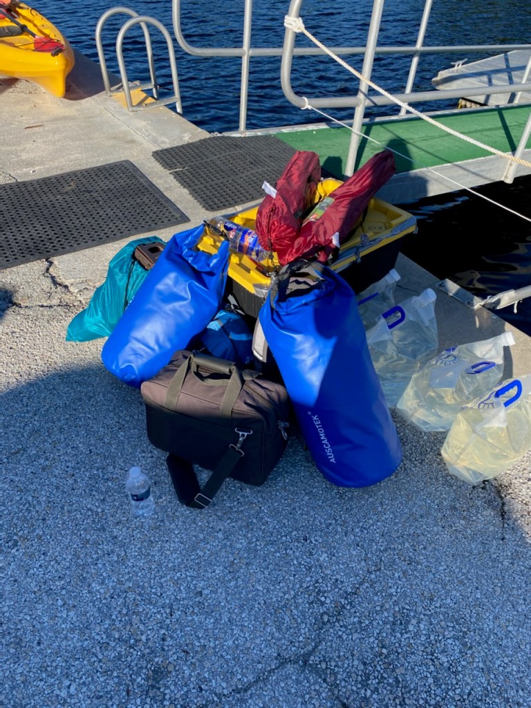
The nice thing about Covid was that the vast majority of the Everglades was wide open, including the South Joe River chickee, and we booked it for the night and then scurried over to the marina to see if we could pick up our reserved canoe a day early. The dockmaster looked at us like we were idiots when we told him our plan, then flat-out told us that it was a bad idea, then warned us that the wind was getting bad and it would be in our faces, then told us that the open water ahead would be much worse than the protected and screened canal of the marina—“There’s a reason it’s called ‘Whitewater Bay,’” he said, with an ominous tone, then tried to give us alternative options, then finally relented and slid a two-person canoe into the water for us with a look on his face as if he was calculating his potential liability. When we unloaded the car and piled our gear onto the dock, he took one look at it and then upgraded us to a three-person canoe, something we were very thankful for later. I tipped him well, then found a water spigot to fill our four 2.5-gallon collapsible water bags. The water came out a sickly yellowish-brown color, but I was assured that it would be fine to drink by the “potable” sign next to the spigot. What could go wrong?
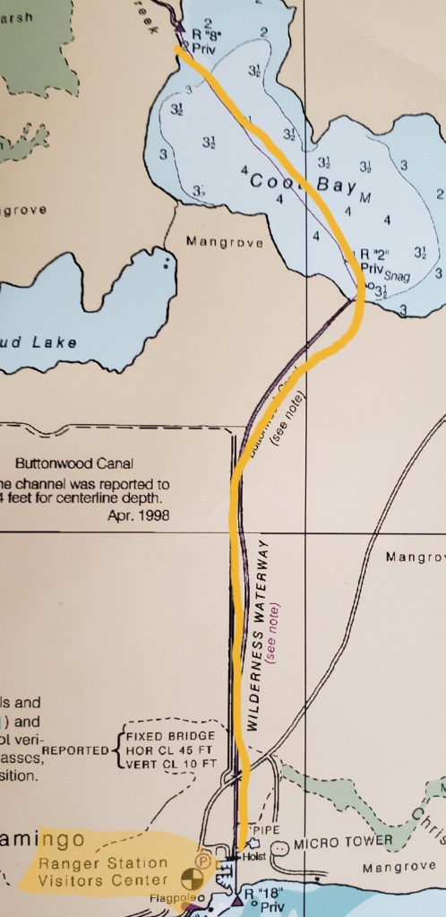
Loading the canoe to the oar-wells, we slid into the Buttonwood Canal at 3:40pm and pushed off for the first stage of the journey, the three-mile paddle up the canal to Coot Bay.
The breeze, though in our face, was manageable and actually quite enjoyable. We got quickly into a rhythm with the paddling, Tracy in the front of the boat and me in the back, her switching from right side to left at her whim, and me switching as necessary to counter her strokes and keep us moving straight ahead. We passed numerous day-paddlers coming in from the bay with smiles and sunburns, saw turtles, numerous birds, and one baby alligator resting on a log as we paddled out. Along the way, we marked a few key spots on the shoreline where we could return to pitch a tent and camp should the bay be as rough as the dockmaster had feared.
We both felt good when we rounded the final bend of the canal and entered Coot Bay, a small bay on the map but a surprisingly large body of water in real life. I was actually a bit dismayed at the real-life size of the bay…if this tiny, almost insignificant bay on the map was this large in person, Whitewater Bay—which we had to cross several times in the next few days—was going to look like an ocean. Nevertheless, with the wind quite a bit stronger here, we hunched our backs, dug the paddles into the water, and propelled our way across it, making for the far end where we would need to find the small canal that connects Coot Bay with its granddaddy, Whitewater Bay. Our heading was true, and the canal opened up, once more providing a windbreak for us. This was what I figured to be the point of no return, where if we pushed on we would be committed to making it all the way to South Joe regardless of the conditions on Whitewater Bay. Tracy agreed that we should continue, and we hurriedly paddled through the short connector with its sharp turns and overhanging mangroves, ever alert for wildlife as the sun marched its way to the horizon.
We entered Whitewater Bay as dusk neared. The bay was every bit as massive as I’d feared after seeing the size of Coot Bay, and we took a moment to marvel at the flat vistas of open water dotted with mangrove islands. There were very few people anywhere in sight, just a couple of faint dots toward the horizon, speedboats too far away even to hear their motors making their way across the bay or getting in some late-day fishing. I took a compass heading and pulled out flashlights and headlamps. Darkness was approaching and we were now certain to be paddling well after sundown. Tracy became somewhat apprehensive about our position, and we stopped for a moment to discuss the situation. At my urging, she let go of her fears and put her trust in me, something I wasn’t too sure was earned. Luckily, as the sun dipped lower, the wind suddenly ceased and the bay grew calm. We took a short rest, letting our canoe drift with the mild current, and then we dug in again, making our way up the vast Joe River.
Darkness descended on us and the stars popped out, lighting up the sky in a brilliant show that was headlined by Jupiter and Saturn. As it grew full dark, we continued to paddle, the deep vee cut by the bow of our boat on the still water of the flat bay the only sign of our passage, the shores of the river too far off to mark our progress. Those shores faded out of sight with the passing of the last light, and I kept us straight by keeping Jupiter and Saturn at our 11:00 position, as well as occasionally turning to mark the bubble of light pollution from the far-away lights of Miami directly at our back.
As we grew more and more comfortable with the idea of paddling into the inky blackness of the Everglades, far from any other people, an island of human life in the midst of a vast area of wilderness and wild animals, we both relaxed, speaking softly and enjoying the solitude and the calmness of the isolation in which we found ourselves immersed. Several meteors streaked overhead, and the silence of the night was broken only by the sounds of our paddles digging into the water and the occasional fish jumping at an insect.
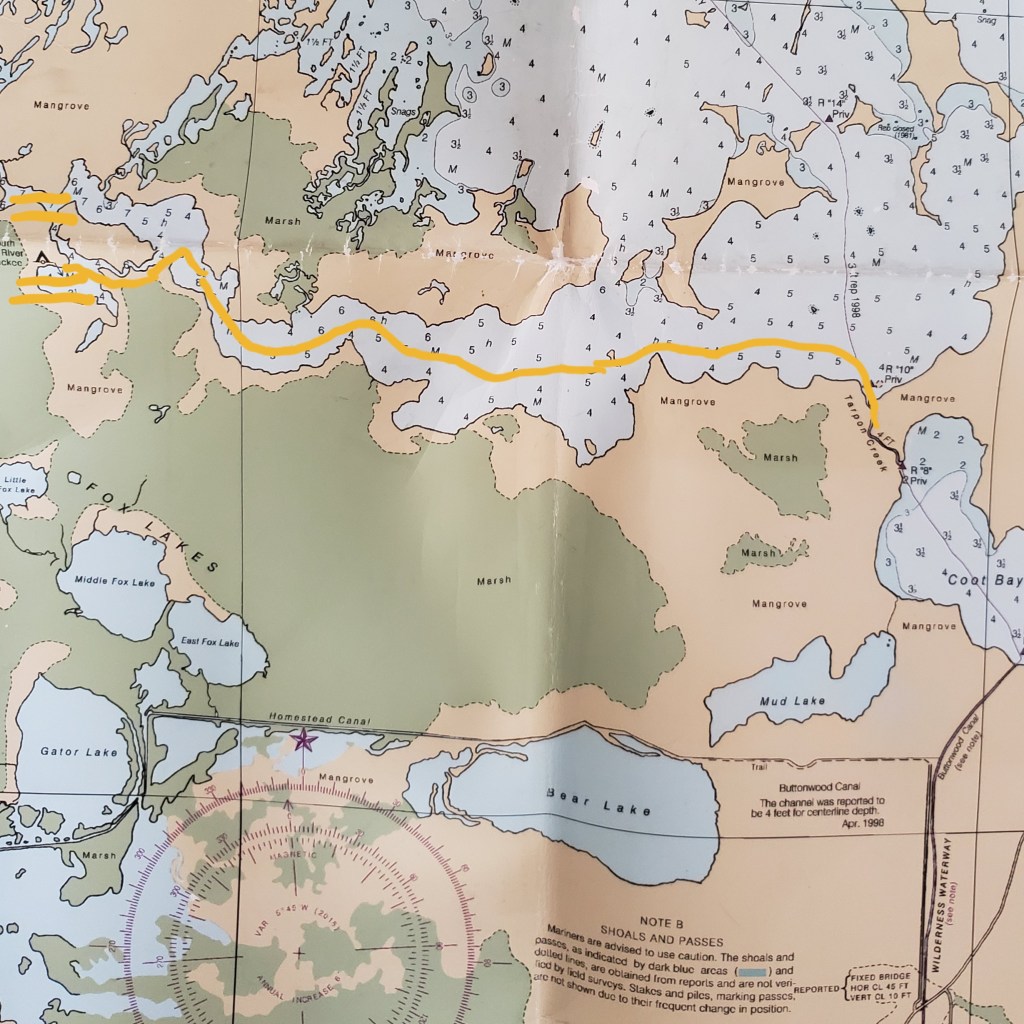
After about an hour, the river narrowed and turned north, and I marked our position on the map as we pulled for the western shore, prepared to search for the canal that led to the small, unnamed bay where the South Joe River chickee would be located. As our headlamps splayed over the mangroves, the river narrowed further, much more than I thought it should based on the map. We pushed on and discovered we’d paddled into a dead-end bay. Slightly unnerved, I scoured the map, searching for answers and trying to figure out our exact location. Tracy asked me where to go next, and I calmly told her to take a quick break as chills of dismay arched down my back and I realized I had no idea where we were.
There’s something deeply unsettling about being lost at night in the Everglades, but I told myself that the worst-case scenario would be that we’d have to find a way to spend the long winter night in the cramped canoe. We weren’t going to die, and we weren’t going to sink in the perfectly calm and smooth water, so I forced myself to relax and think through the problem. As my eyes searched for where we’d gone wrong, I realized what the problem was. I’d been looking for the river to make a turn to the north, and so when the opening appeared on the north bank, I assumed that was the actual turn, instead of the small bay that was clearly marked on the map. The scale of the map had fooled me again, the darkness and identicality of the shoreline of nothing but never-ending mangroves tricking me into thinking we’d reached our turn when we hadn’t. We paddled back out of the bay, staying close to the inhospitable shoreline in order to avoid being tricked again.

I soon realized that this map, as high-quality as it was, was going to be a problem for detailed navigation. Large inlets and bays in real-life appeared as nothing more than a squiggle on the map, and every one had to be explored before we could be confident we were not missing the turn of the Joe River to the north. A light mist began to rise eerily out of the mangrove forests, spreading across the calm water like groping fingers, diffusing the light from our headlamps, chilling the air, and giving a spooky, ethereal feel to the night that caused us both to shiver. This was beginning to feel like a scene in a horror movie where the audience wonders how the protagonists could have possibly ended up in such a terrible situation.
Eventually, we paddled all the way across the river, keeping the left shore close to us like lost children in a blind maze who keep their left hands on the wall to find their way out. As it became quite clear that we had finally made the correct turn to the north, I began to breathe easier, and when the canal leading to the South Joe chickee bay eventually opened up out of the mist to our left, my heart began to settle down slightly. We navigated through the turns of the tight, stygian canal with the ghostly mangroves scratching the walls of our canoe. Finally, the small bay opened up before us and the mist cleared suddenly, as if obeying a heavenly command. Pointing the bow of the canoe to where I thought the chickee should be, I told Tracy to focus her flashlight across the small inlet to the far shore. As the beam of light hit the other side of the inlet, a reflective sign bounced the light back to us and we both breathed a sigh of relief at the first sign of civilization we’d seen in hours. We’d found the South Joe River chickee.
We pulled up to the empty chickee at just before 8:00pm. We’d only paddled for less than 4.5 hours, but we were relieved to be done. Tying up to the chickee, we quickly unloaded the canoe, set up our tent, and cooked dinner. We’d covered 13.5 miles, several of which had been hard miles hampered by wind, waves, and the incoming tide. We’d earned a hearty dinner and a good night’s sleep. We sat in our chairs enjoying the perfect stillness, the bright stars, and the calm, temperate evening before eventually climbing into the tent and falling fast asleep.

Published by